
11.4 Types of Volcanic Eruptions
Volcanoes produce a variety of materials when they erupt. The characteristics of the eruptions themselves also vary from one volcano to the next, and sometimes from one eruption to the next for the same volcano. Eruptions are classified according how explosive they are, and the height of their eruption column– how high they blast material into the air.
Both the explosiveness of an eruption and the height of the eruption column are related in part to the composition of magma and the amount of gas it contains. In particular, magmas with more silica erupt more explosively. The higher the silica content, the greater the viscosity of the magma. This means more pressure can build up before the magma is forced out of the volcano. Magma with more silica also tends to contain more dissolved gas. The gas helps to propel magma out of the volcano, in the same way that the bubbles in a shaken bottle of pop cause the pop to foam out when the lid is removed.
There are four types of eruptions with properties determined mostly by the silica content of magma, and the amount of gas it contains. In order of increasing explosiveness, these are Hawai’ian, Strombolian, Vulcanian, and Plinian eruptions. Any composition of magma can have an explosive eruption if the magma suddenly encounters water. Hot magma contacting groundwater or seawater causes the water to flash to steam. Explosive eruptions driven by water are called hydrovolcanic (or phreatic) eruptions.
Hawai‘ian Eruptions
Hawai‘ian eruptions are named after the characteristic eruptions of volcanoes of the Hawai‘ian islands. Hawai‘ian eruptions are effusive (flowing) rather than explosive because they erupt low-viscosity basaltic lava. Hawai‘ian eruptions form shield volcanoes and can also take the form of fissure eruptions. Fissure eruptions occur when lava erupts from long cracks in the ground rather than from a central vent.
Figure 11.26 shows examples from two eruptions on of Hawai‘i. In the upper left and right are images from the November 1959 eruption of Kīlauea Iki Crater. The upper left shows a fissure eruption and effusive flow of lava. Burning trees appear as bright spots toward the bottom of the photo. Figure 11.26 (right) shows a lava fountain reaching 425 m above Kīlauea Iki Crater. U. S. Geological Survey scientists reported that volcanic bombs up to 60 cm across smashed the guard rail and dented the asphalt on the road. Figure 11.26 (lower left) shows Hawaiian Volcano Observatory (HVO) scientists making a quick getaway, with lava fountains from Mauna Loa Volcano in the background.
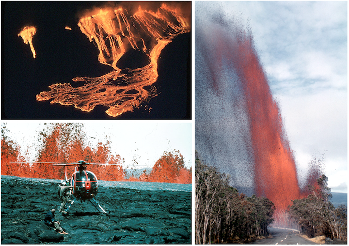
The photographs of the Kīlauea Iki Crater and Mauna Loa Volcano eruptions make the point that while Hawai‘ian eruptions are considered “gentle” eruptions, this is a relative term. “Gentle” eruptions range from lava flows that can be safely sampled by trained personnel, as in Figure 11.5, to lava fountains that soar hundreds of metres above the tree tops and rain large and dangerous rocks upon the surroundings.
Strombolian Eruptions
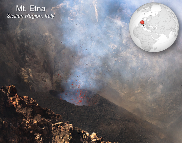
Strombolian eruptions, named for Mt. Stromboli in Italy, occur when basaltic lava has higher viscosity and higher gas content. The sticky lava is ejected in loud, violent, but short-lived spattery eruptions. Clumps of gas-rich lava thrown 10s to 100s of metres in the air accumulate as scoria in a pile around the vent, forming cinder cones. Figure 11.27 shows a strombolian eruption in the crater of Mt. Etna. A smaller cinder cone is forming around the vent as lava sputters out of it.
Vulcanian Eruptions
Vulcanian eruptions get their name from the volcanic Italian island of Vulcano, which itself takes the name of the Roman god of fire, Vulcan. In Roman mythology, Vulcan was the maker of armour and weaponry for the gods, and volcanic eruptions were attributed to him working in his forge.
Vulcanian eruptions are far more explosive than Strombolian eruptions, and can blast tephra and gas to a height of 5 to 10 km. The explosiveness is related to a build-up of pressure as the higher viscosity of intermediate silica content lava restricts the escape of gas. Vulcanian eruptions produce large quantities of ash in addition to blocks and bombs.
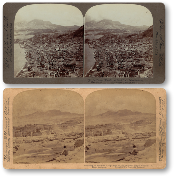
The Vulcanian eruption of Mt. Pelée on the island of Martinique in 1902 resulted in the first detailed documentation by geologists of a devastating phenomenon that is now referred to as a pyroclastic flow (Figure 11.28). Volcanic debris from the collapse of a lava dome on Mt. Pelée combined with hot gas to form a searing avalanche that raced down the mountain, over the city of St. Pierre, and into the harbour.
The French geologist Alfred Lacroix described what he saw as a “nuée ardente,” or thick fiery cloud. The following first-hand account was published in Cosmopolitan Magazine in July of 1902, attributed to Ellery S. Scott, a sailor on the steamship Roraima:
Plinian Eruptions
Plinian eruptions are explosive eruptions of intermediate to felsic lava, and can form eruptive columns up to 45 km high. The origin of the name is the eruption of Vesuvius in 79 CE, which buried the towns of Pompeii and Herculaneum. The Roman admiral Gaius Plinius Secundus, also known as Pliny the Elder, attempted a rescue mission when he saw the column of ash and debris above Vesuvius, but died of unknown causes without being able to reach Herculaneum.
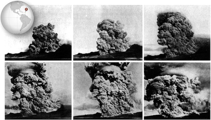
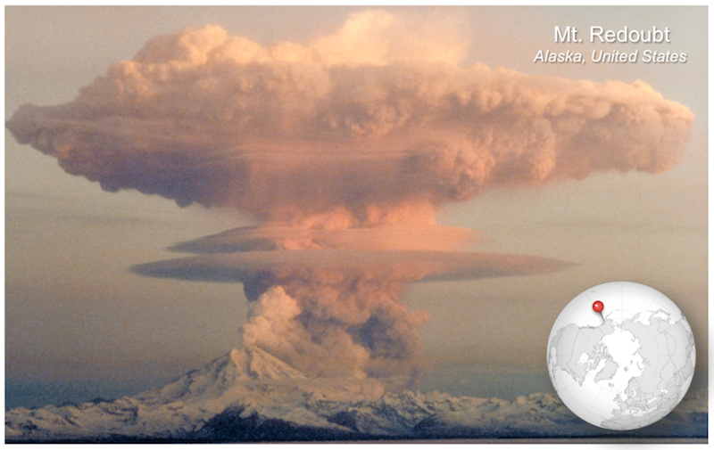
A more recent Plinian eruption was that of Mt. Redoubt on April 21, 1990, shown in Figure 11.30. Pyroclastic flows resulted, as did lahars, landslides that formed when glaciers melted and turned volcanic ash into mud. The shape of the eruptive column, with parts of the column appearing to spread out in flat layers at different levels, reflects differences in atmospheric characteristics.
Hydrovolcanic (Phreatic) Eruptions
Hydrovolcanic eruptions can be far more explosive than Plinian eruptions. They occur when water in the form of groundwater, seawater, or even melting glacial ice or snow comes into contact with magma. Heat from the magma changes water suddenly to steam, which can expand to more than a thousand times the original volume of water. The sudden expansion results in an explosive force that can blast a volcano to pieces and create large amounts of volcanic ash.
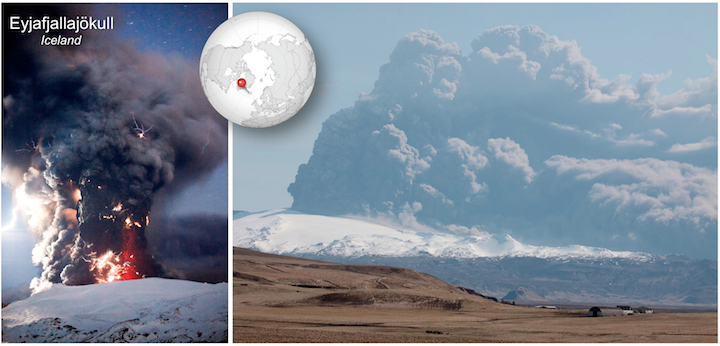
In April of 2010, activity by the Icelandic volcano Eyjafjallajökull (Figure 11.31) melted the glacier above it, releasing large quantities of water and triggering a hydrovolcanic eruption. Ash rose in a plume 10 km high, and was blown westward and into the skies over Europe. Volcanic ash can damage or destroy aircraft engines, so the precaution was taken to prohibit air travel for a 5-day period. The enormous economic impact of stopping flights has led to numerous studies about the best way to deal with similar events with volcanic ash in the future.
References
Bressan, D (2012). Geology Scene Investigation: Death by Volcanic Fire. Visit website
British Geological Survey (n.d.). Eyjafjallajökull eruption, Iceland | April/May 2010. Visit website
Digital History Project (2011). “Eyewitness Account to Eruption of Mont Pelee Matinique St Pierre Fort de France” By Ellery S. Scott. Visit website
Rosen, J. (2015). Benchmarks: May 8, 1902: The deadly eruption of Mount Pelée. Visit website
U. S. Geological Survey (1997). Pyroclastic flows. Visit website
