17.2 Glacial Erosion
Glaciers are effective agents of erosion, especially in situations where the base of the glacier is not frozen to the underlying material and can therefore slide over the bedrock or other sediment. The ice itself is not particularly effective at erosion because it is relatively soft (Mohs hardness 1.5 at 0°C). Glacial erosion is primarily driven by abrasion of the underlying rocks by rock fragments embedded within the ice. These rocks are pushed down onto the underlying surfaces by the ice, and because they are hard they can gouge and grind down the materials beneath the glacier. An analogy for these processes is to compare the effect of a regular piece of paper being rubbed against a wooden surface (“ice eroding rock”) to rubbing a piece of sandpaper over the same surface (“ice with embedded rocks eroding rock”). The results of glacial erosion are different in areas with continental glaciation versus alpine glaciation.
Continental Glacial Erosion Features
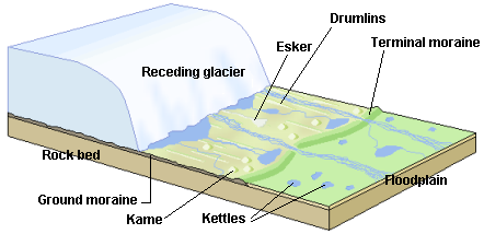
Continental glaciation tends to produce relatively flat bedrock surfaces, especially where the rock beneath is uniform in strength. In areas where there are differences in the strength of rocks, a glacier tends to erode the softer and weaker rock more effectively than the harder and stronger rock. Much of central and eastern Canada, which was completely covered by the huge Laurentide Ice Sheet at various times during the Pleistocene Epoch, has been eroded to a relatively flat surface. Glacial deposits have created distinctive topographic features on the landscapes in these regions — such as drumlins, eskers, and moraines (Figure 17.16). These continental glacial features are deposits of glacial materials and are described further in Section 17.3.
In areas of continental glaciation, the lithosphere is depressed by the weight of glacial ice that is up to 4,000 m thick. Basins formed along the edges of continental glaciers; for example, basins formed around the edges of the Laurentide Ice Sheet that once covered much of Canada (Section 17.4). These basins filled with glacial meltwater, and layers of sediments. Many such lakes, some of them huge, existed at various times along the southern edge of the Laurentide Ice Sheet.
One example of these lakes was Glacial Lake Missoula, which formed within Idaho and Montana, just south of the BC border with the United States. During the latter part of the last glaciation (30 ka to 15 ka), the ice holding back Lake Missoula retreated enough to allow some of the lake water to escape, which escalated into a voluminous and rapid outflow (over days to weeks). During this outflow, most of the lake drained into the Columbia River valley and flowed to the Pacific Ocean. It is estimated that this type of catastrophic outflow happened at least 25 times during this period, and in many cases, the rate of outflow was equivalent to the discharge of all of Earth’s current rivers combined.
Alpine Glacial Erosion Features
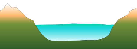
Alpine glaciers produce very different topography than continental glaciers. Alpine glaciers produce wide valleys with relatively flat bottoms and steep sides due to the erosion that occurs at the base and edges of the glaciers. These are known as U-shaped valleys (Figure 17.17). In contrast, unglaciated river valleys generally have a V shape.
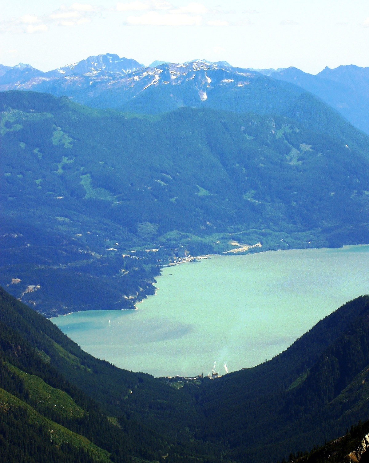
In coastal regions where the bottom of the valley is filled with water, the U-shaped valleys are called fjords. The coastal mountains of BC have many fine examples of U-shaped valleys and fjords. For example, Howe Sound is a fjord that was once occupied by a large glacier. Howe Sound and most of its tributary valleys have pronounced U-shaped profiles due to glaciation (Figure 17. 18).
Several other topographic features derived from alpine glacial erosion are found in U-shaped valleys and their tributary valleys (Figure 17.19). Arêtes are sharp ridges formed between U-shaped glacial valleys. Cols are low points (saddles) along arêtes; they form passes (high points) between glacial valleys. Horns are steep peaks that have been eroded by glaciers and freeze-thaw activity on three or more sides. Cirques are bowl-shaped basins that form at the head of a glacial valley, and tarns are lakes that form when cirques are flooded. Hanging valleys form when U-shaped valleys of tributary glaciers connect with a larger U-shaped valley; the tributary valley hangs above the main valley because the larger main-valley glacier is eroded more deeply into the terrain. Truncated spurs (aka “spurs”) are features at the ends of arêtes where the rock is eroded into steep triangle-shaped cliffs by the glacier in the main valley.
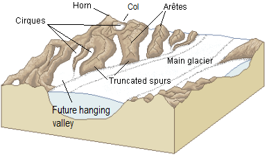
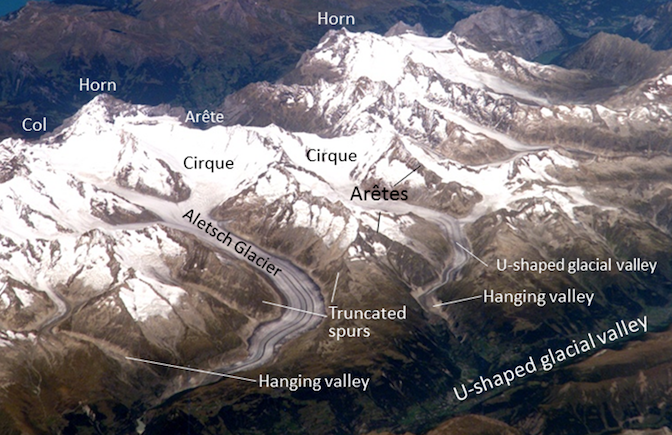
Figure 17.20 shows examples of these features in the Swiss Alps. The area in the image was intensely glaciated during the past glacial maximum and still contains glaciers. The large U-shaped valley in the lower right was occupied by glacial ice historically, and all of the other glaciers shown here were longer and much thicker than they are now. But even at the peak of the Pleistocene glaciation, some of the higher peaks and ridges in this image would have been exposed and not directly affected by glacial erosion. A peak that extends above the surrounding glacier is called a nunatak. In these areas, and in the areas above the glaciers in the image today, most of the erosion is linked to freeze-thaw action.
A roche moutonnée is aglacial erosion feature that forms when a glacier moves over an outcrop of bedrock. Roche moutonnées consist of a hill of rock, often with a smooth, often low angle slope on one side, and a steeper and jagged slope on the other side. The side that is smooth and relatively low angle is the side the glacier was flowing from, and the a steep and sometimes jagged side is the direction the ice was moving (Figure 17.21, left).

Glacial grooves (tens of centimetres to metres wide) and glacial striae (millimetres to centimetres wide) are created by the erosion caused by fragments of rock embedded in the ice at the base of a glacier (Figure 17.22, left and right). Glacial striae are very common on rock surfaces eroded by both alpine and continental glaciers. Glacial polish occurs when the abrasion of the rock by the glacier renders the rock so smooth it reflects light.

Lakes are common features in glacial environments. A lake that is confined to a glacial cirque is known as a tarn (Figure 17.23). Tarns are common in areas of alpine glaciation because the ice that forms a cirque typically carves out a depression in bedrock that can then fill with water. Moraines, which are linear deposits of glacial sediments (till) left by the glacier along its edges, can form a dam at the end of a tarn. Often, a series of moraines will form as glaciers recede. These can act as water dams, and result in strings of lakes called rock basin lakes or paternoster lakes.

A lake that occupies a glacial valley is known as a finger lake. In some cases, a finger lake is confined by a dam formed by an end moraine, in which case it may be called a moraine lake (Figure 17.24). Another type of glacial lake is a kettle lake. These are discussed in section 17.4 in the context of glacial deposits.

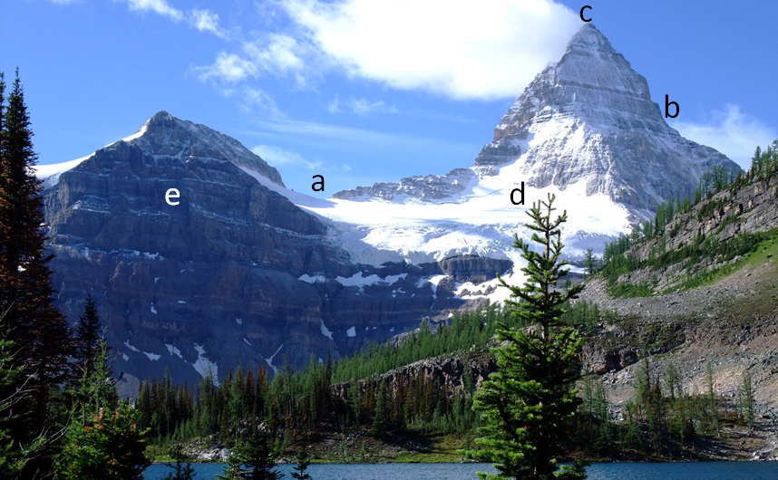
Exercise: Identifying Glacial Erosion Features
Figure 17.25 is a photo of Mt. Assiniboine in the BC Rocky Mountains. What are the features at locations a through e? Look for one of each of the following: a horn, an arête, a truncated spur, a cirque, and a col. Try to identify some of the numerous other arêtes in this view, as well as another horn.