
4.4 Plates, Plate Motions, and Plate-Boundary Processes
The ideas of continental drift and sea-floor spreading became widely accepted by 1965, and more geologists started thinking in these terms. By the end of 1967, Earth’s surface had been mapped into a series of plates (Figure 4.23). The major plates are Eurasian, Pacific, Indian, Australian, North American, South American, African, and Antarctic plates. There are also numerous small plates (e.g., Juan de Fuca, Nazca, Scotia, Philippine, Caribbean), and many very small plates or sub-plates. The Juan de Fuca Plate is actually three separate plates (Gorda, Juan de Fuca, and Explorer), all moving in the same general direction but at slightly different rates.
![Figure 4.18 A detailed map of Earth's tectonic plates. [Source: NASA, http://bit.ly/1PZHRMZ]](https://openpress.usask.ca/app/uploads/sites/29/2017/05/Plate_tectonics_map.gif)
Plate motions can be tracked using Global Positioning System (GPS) data from different locations on Earth’s surface. Rates of motions of the major plates range from less than 1 cm/y to more than 10 cm/y. The Pacific Plate is the fastest, moving at more than 10 cm/y in some areas, followed by the Australian and Nazca Plates. The North American Plate is one of the slowest, averaging ~1 cm/y in the south up to almost 4 cm/y in the north.
Plates move as rigid bodies, so it may seem surprising that the North American Plate can be moving at different rates in different places. The explanation is that plates rotate as they move; the North American Plate, for example, rotates counter-clockwise, while the Eurasian Plate rotates clockwise.
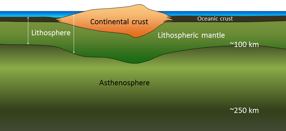
Boundaries between the plates are of three types: divergent (moving apart), convergent (moving together), and transform (moving side by side). The plates are made up of crust and lithospheric mantle (Figure 4.24). Even though the plates are in constant motion, and move in different directions, there is never a significant amount of space between them. Plates move along the lithosphere-asthenosphere boundary, because the asthenosphere is relatively weak. It deforms as the plates move, rather than locking them in place.

At spreading centres, the lithospheric mantle is relatively thin. The upward convective motion of hot mantle material generates temperatures that are too high for the existence of a significant thickness of rigid lithosphere at the same time that the plates are falling away from each other (Figure 4.17).
The fact that plates include both crustal material and lithospheric mantle material makes it possible for a single plate to be include both oceanic and continental crust. The North American Plate includes most of North America, plus half of the northern Atlantic Ocean. Similarly the South American Plate extends across the western part of the southern Atlantic Ocean, while the European and African plates each include part of the eastern Atlantic Ocean. The Pacific Plate is almost entirely oceanic, but it does include the part of California west of the San Andreas Fault.
Divergent Boundaries
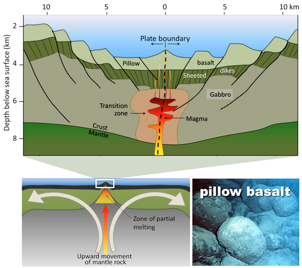
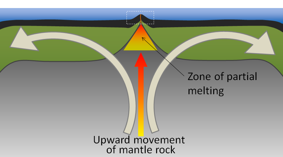
Divergent boundaries are spreading boundaries, where new oceanic crust is created from magma derived from partial melting of the mantle. The partial melting happens when hot mantle rock is moved from deep within Earth where pressures are too high for it to be liquid, to shallower depths where the pressure is much lower (Figure 4.25, bottom left).
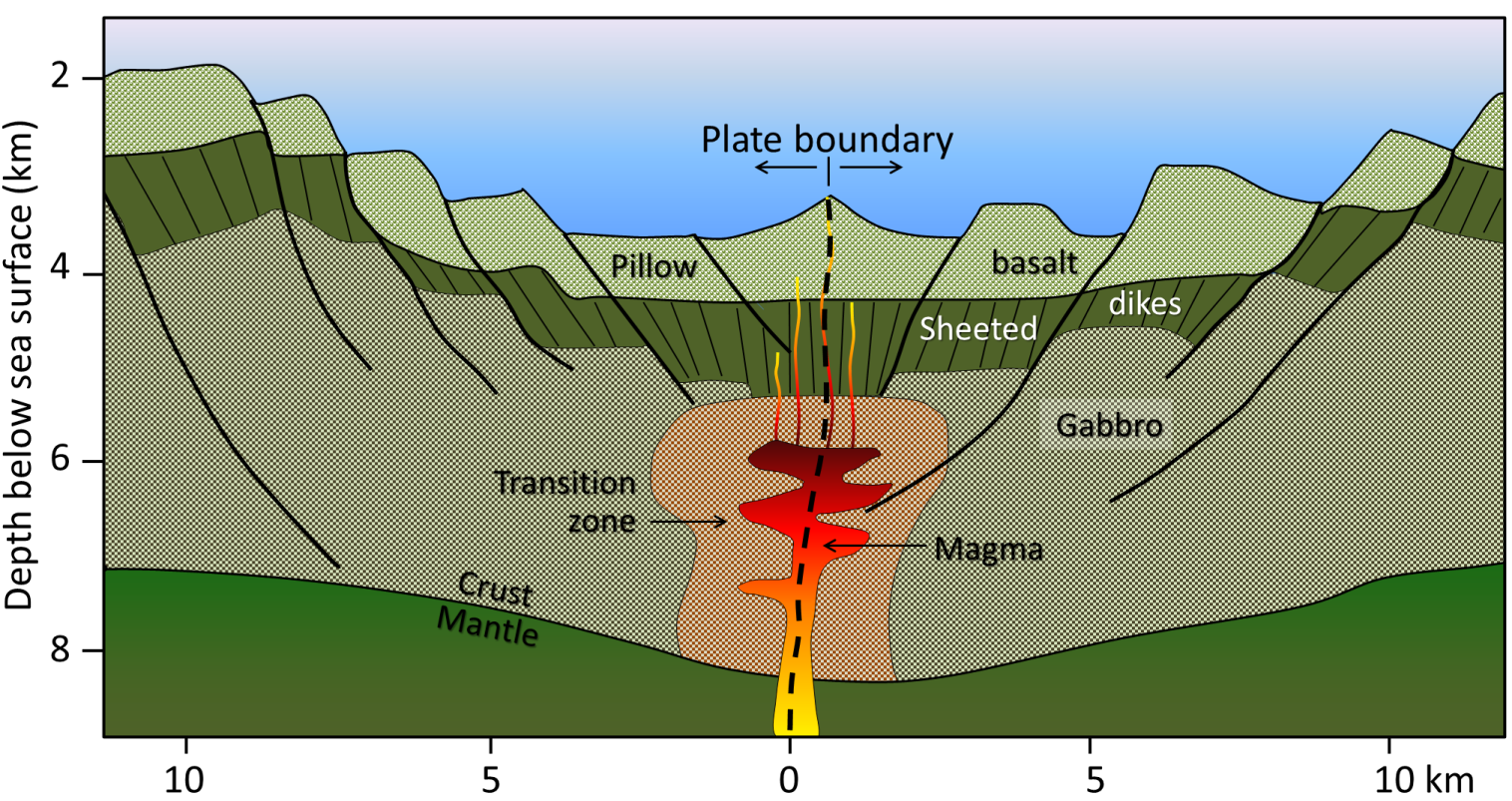
The triangular zone of partial melting near the ridge crest is approximately 60 km thick and the proportion of magma is about 10% of the rock volume, thus producing crust that is about 6 km thick once the melt escapes from the rock in which it formed, and ascends. Most divergent boundaries are located in the oceans, and the crustal material created at a spreading boundary is always oceanic in character; in other words, it is mafic igneous rock (basalt or gabbro, with minerals rich in iron and magnesium). Spreading rates vary considerably, from 1 cm/y to 3 cm/y in the Atlantic, to between 6 cm/y and 10 cm/y in the Pacific. Some of the processes taking place in this setting include (Figure 4.25, top):
- Melted rock (magma) from the mantle rising up to fill the voids left by divergence of the two plates
- Pillow lavas forming where melted rock emerges on the ocean floor and is cooled by seawater (Figure 4.25, bottom right)
- Vertical sheeted dykes intruding into cracks resulting from the spreading
- Magma cooling more slowly in the lower part of the new crust, forming bodies of gabbro
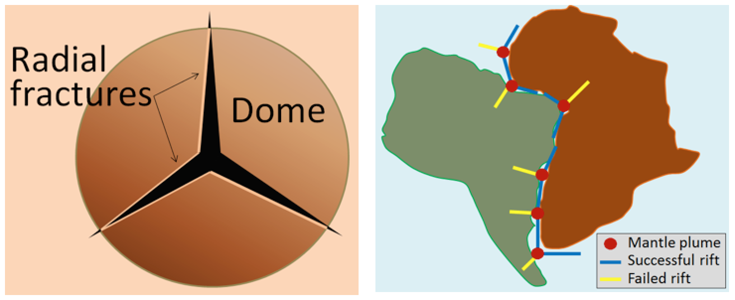
Spreading is thought to start with lithosphere being warped upward into a dome by buoyant material from an underlying mantle plume or series of mantle plumes. The buoyancy of the mantle plume causes the dome to fracture in a radial pattern, with three arms spaced at approximately 120° (Figure 4.26).
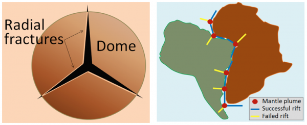
When a series of mantle plumes exists beneath a large continent, the resulting rifts may align and lead to the formation of a rift valley, such as the present-day Great Rift Valley in eastern Africa. This type of valley may eventually develop into a linear sea (such as the present-day Red Sea), and finally into an ocean (such as the Atlantic). It is likely that as many as 20 mantle plumes, many of which still exist, were responsible for the initiation of the rifting of Pangea along what is now the mid-Atlantic ridge (see the Atlantic Ocean mantle plume locations in Figure 4.19).
Convergent Boundaries
Convergent boundaries, where two plates are moving toward each other, are of three types, depending on whether ocean or continental crust is present on either side of the boundary. The types are ocean-ocean, ocean-continent, and continent-continent.
Ocean-Ocean Convergent Boundaries
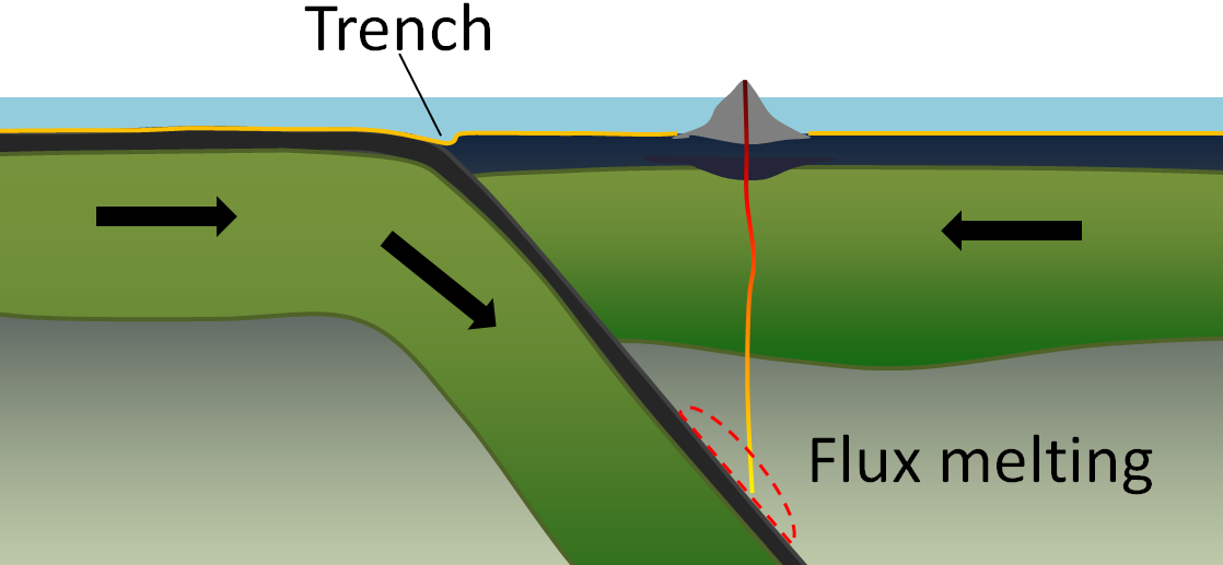
At an ocean-ocean convergent boundary, a plate margin consisting of oceanic crust and lithospheric mantle is subducted, or travels beneath, the margin of the plate with which it is colliding (Figure 4.27). Often it is the older and colder plate that is denser and subducts beneath the younger and hotter plate. Ocean trenches commonly form along these boundaries.

As the subducting crust is heated and the pressure increases, water is released from within the subducting material. This water comes primarily from alteration of the minerals pyroxene and olivine to serpentine near the spreading ridge shortly after the rock’s formation. The water mixes with the overlying mantle, which lowers the melting point of mantle rocks, causing magma to form. This process is called flux melting or fluid-induced melting.
The newly produced magma, which is lighter than the surrounding mantle rocks, rises through the mantle and sometimes through the overlying oceanic crust to the ocean floor where it creates a chain of volcanic islands known as an island arc. A mature island arc develops into a chain of relatively large islands (such as Japan or Indonesia) as more and more volcanic material is extruded and sedimentary rocks accumulate around the islands. The largest earthquakes occur near the surface where the subducting plate is still cold and strong.
Examples of ocean-ocean convergent zones are subduction of the Pacific Plate south of Alaska (Aleutian Islands) and west of the Philippines, subduction of the Indian Plate south of Indonesia, and subduction of the Atlantic Plate beneath the Caribbean Plate.
Ocean-Continent Convergent Boundaries
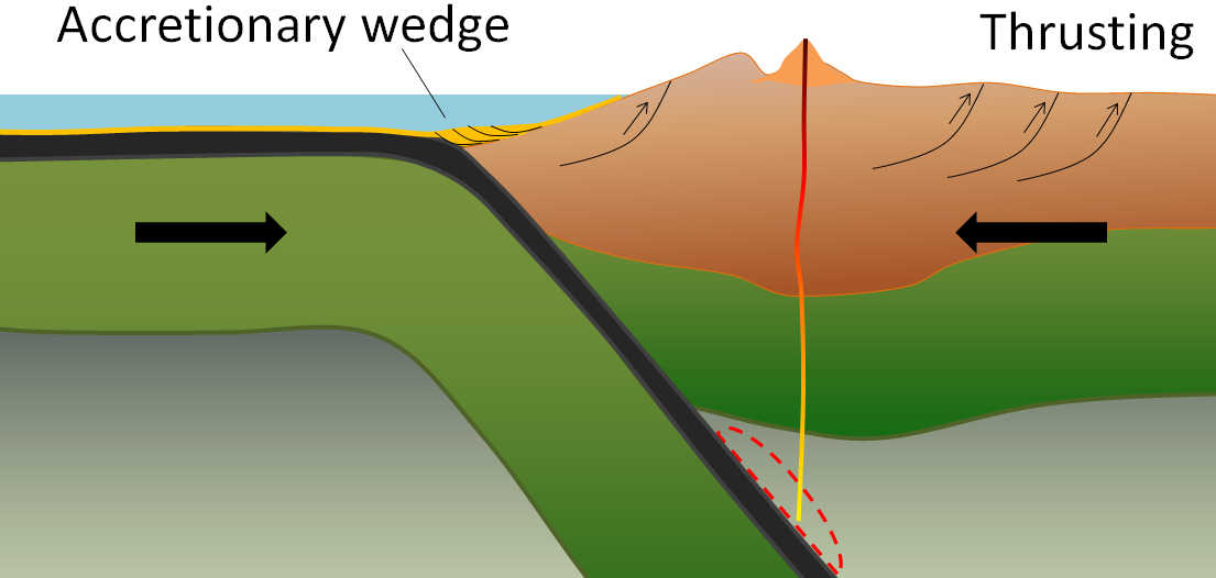
At an ocean-continent convergent boundary, the oceanic plate is subducted beneath the continental plate in the same manner as at an ocean-ocean boundary. Rocks and sediment on the continental slope are thrust up into an accretionary wedge, and compression leads to faults forming within the continental plate (Figure 4.28). The mafic magma produced adjacent to the subduction zone rises to the base of the continental crust and leads to partial melting of the crustal rock. The resulting magma ascends through the crust, producing a mountain chain with many volcanoes.
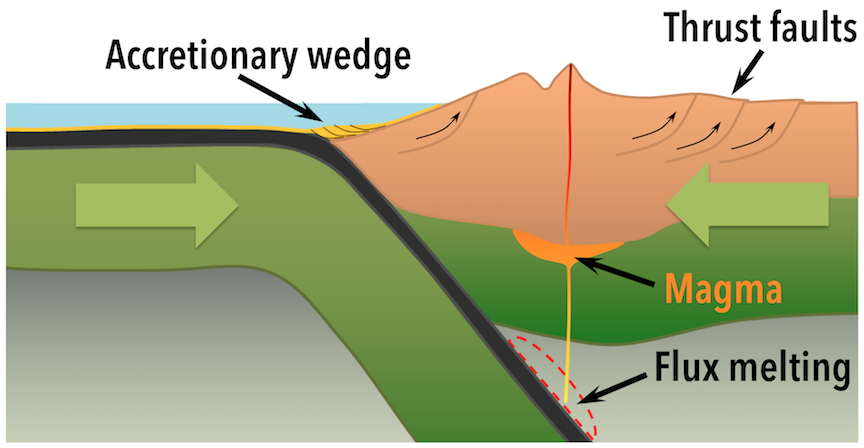
Examples of ocean-continent convergent boundaries are subduction of the Nazca Plate under South America (which has created the Andes Range) and subduction of the Juan de Fuca Plate under North America (creating the mountains Garibaldi, Baker, St. Helens, Rainier, Hood, and Shasta, collectively known as the Cascade Range).
Continent-Continent Convergent Boundary
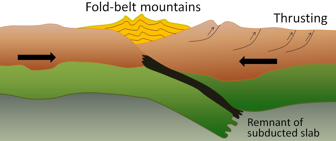
A continent-continent collision occurs when a continent or large island that has been moved along with subducting oceanic crust collides with another continent (Figure 4.29). The colliding continental material will not be subducted because it is not dense enough, but the root of the oceanic plate will eventually break off and sink into the mantle. There is tremendous deformation of the pre-existing continental rocks, and creation of mountains from that rock, as well as from any sediments that had accumulated along the shores of both continental masses, and commonly also from some ocean crust and upper mantle material.

Examples of continent-continent convergent boundaries are the collision of the India Plate with the Eurasian Plate, creating the Himalaya Mountains, and the collision of the African Plate with the Eurasian Plate, creating the series of ranges extending from the Alps in Europe to the Zagros Mountains in Iran.
When a subduction zone is jammed shut by a continent-continent collision, plate tectonic stresses that are still present can sometimes cause a new subduction zone to develop outboard of the colliding plate.
Transform Boundaries
Transform boundaries exist where one plate slides past another without producing or destroying crust, except in the special case where the transform boundary has bends and jogs. There will be collisions and divergence on a small scale as the jogs crash into the bends, or open up small windows to deeper crust.
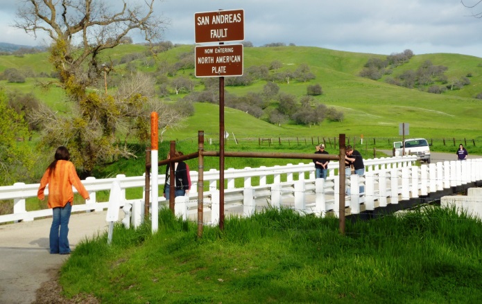
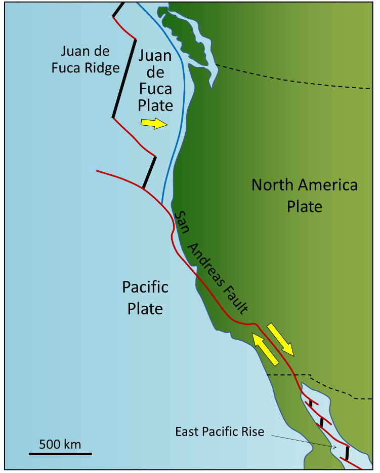
Most transform faults connect segments of mid-ocean ridges and are thus ocean-ocean plate boundaries (Figure 4.20). Some transform faults connect continental parts of plates. An example is the San Andreas Fault, which connects the southern end of the Juan de Fuca Ridge with the northern end of the East Pacific Rise (a ridge) in the Gulf of California (Figures 4.30 and 4.31). The part of California west of the San Andreas Fault and all of Baja California are on the Pacific Plate. But transform faults do not just connect divergent boundaries; the Queen Charlotte Fault connects the north end of the Juan de Fuca Ridge, starting at the north end of Vancouver Island, to the Aleutian subduction zone.

Exercise: A Different Type of Transform Fault
Figure 4.32 shows the Juan de Fuca (JDF) and Explorer plates off the coast of Vancouver Island. The JDF Plate is moving toward the North American Plate at ~ 4.5 cm/y. We think that the Explorer Plate is also moving east, but we don’t know the rate, and there is evidence that it is slower than the JDF Plate.
The boundary between the two plates is the Nootka Fault, which is the location of frequent small-to-medium earthquakes (up to magnitude ~5), as depicted by the red stars. Explain why the Nootka Fault is a transform fault, and show the relative sense of motion along the fault with two small arrows.
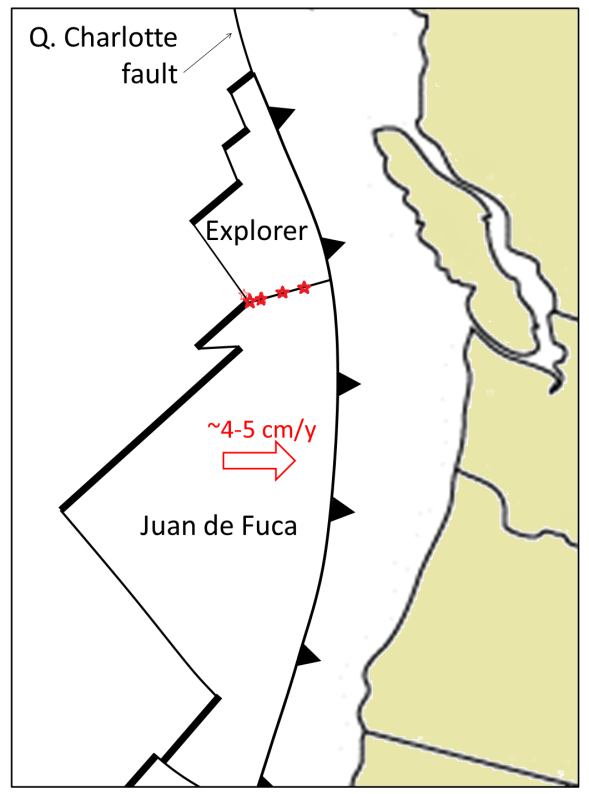
Plate Tectonics and Supercontinent Cycles
The present continents were once all part of a supercontinent that Alfred Wegener named Pangea (all land). More recent studies of continental matchups and the magnetic ages of ocean-floor rocks have enabled us to reconstruct the history of the break-up of Pangea.
Pangea began to rift apart along a line between Africa and Asia and between North America and South America at around 200 Ma (Figure 4.33). During the same period the Atlantic Ocean began to open up between northern Africa and North America, and India broke away from Antarctica. Between 200 and 150 Ma, rifting started between South America and Africa and between North America and Europe, and India moved north toward Asia. By 80 Ma, Africa had separated from South America, and most of Europe had separated from North America. By 50 Ma, Australia had separated from Antarctica, and shortly after that, India collided with Asia.
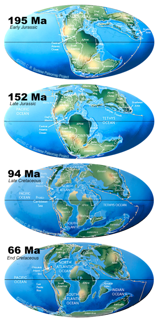
Within the past few million years, rifting has occurred in the Gulf of Aden and the Red Sea, and also within the Gulf of California. Incipient rifting has begun along the Great Rift Valley of eastern Africa, extending from Ethiopia and Djibouti on the Gulf of Aden (Red Sea) all the way south to Malawi.
Pangea was not the first supercontinent. It was preceded by Pannotia (600 to 540 Ma), Rodinia (1,100 to 750 Ma), and by others before that. In fact, in 1966, Tuzo Wilson proposed that supercontinents are part of an on-going cycle, which we now refer to as a Wilson cycle. In a Wilson cycle, continents break up, and fragments drift apart only to collide again and make a new continent.
At present we are in the stages of a Wilson cycle where fragments are drifting and changing their configuration. North and South America, Europe, and Africa are moving with their respective portions of the Atlantic Ocean. The eastern margins of North and South America and the western margins of Europe and Africa are called passive margins because there is no subduction taking place along them. Because the oceanic crust formed by spreading along the mid-Atlantic ridge is not currently being subducted (except in the Caribbean), the Atlantic Ocean is slowly getting bigger, and the Pacific Ocean is getting smaller.
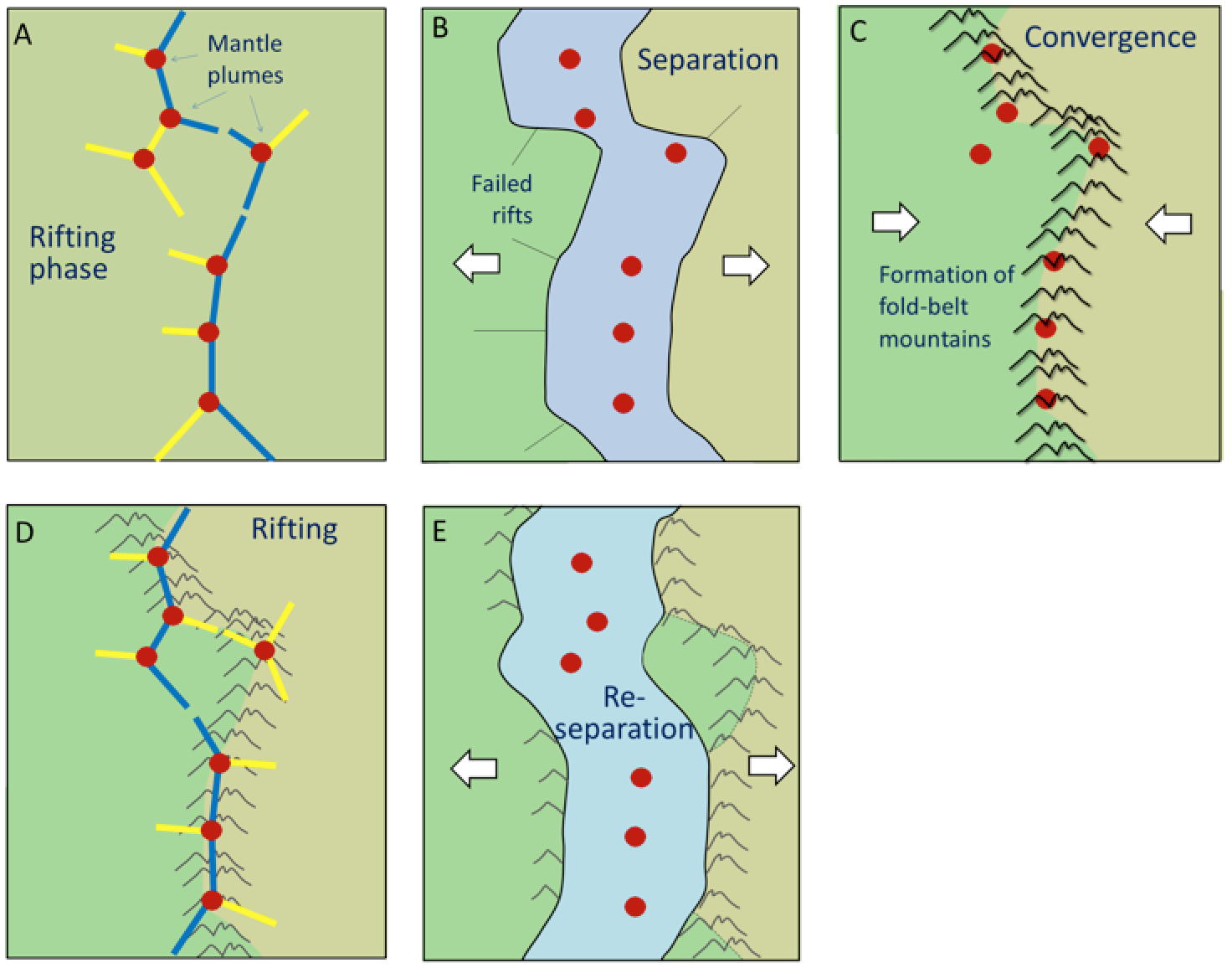
This situation may not continue for too much longer, however. As the Atlantic Ocean floor gets weighed down around its margins by great thickness of continental sediments, it will be pushed farther and farther into the mantle, and eventually the oceanic lithosphere may break away from the continental lithosphere and begin to subduct (Figure 4.34).
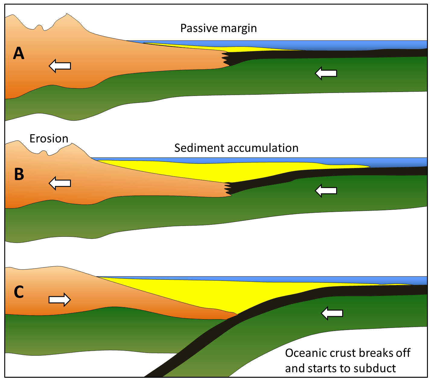
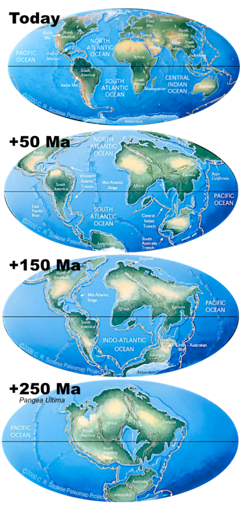
A subduction zone will develop, and the oceanic plate will begin to descend under the continent. Once this happens, the continents will no longer continue to move apart because the spreading at the mid-Atlantic ridge will be taken up by subduction. If spreading along the mid-Atlantic ridge continues to be slower than spreading within the Pacific Ocean, the Atlantic Ocean will start to close up, and eventually (in a 100 million years or more) North and South America will collide again with Europe and Africa. If this continues without changing for another few hundred million years, we will be back to where we started, with one supercontinent (Figure 4.35).
There is strong evidence around the margins of the Atlantic Ocean that this process has taken place before. There are roots of ancient mountain belts along the eastern margin of North America, the western margin of Europe, and the north-western margin of Africa, which show that these landmasses once collided with each other to form a mountain chain. The mountain chain might have been as big as the Himalayas.
The apparent line of collision runs between Norway and Sweden, between Scotland and England, through Ireland, through Newfoundland and the Maritimes, through the north-eastern and eastern states, and across the northern end of Florida. When rifting of Pangea started at approximately 200 Ma, the fissuring was along a different line from the line of the earlier collision. This is why some of the mountain chains formed during the earlier collision can be traced from Europe to North America and from Europe to Africa.
It is probably no coincidence that the Atlantic Ocean rift may have occurred in approximately the same place during two separate events several hundred million years apart. The series of hot spots that has been identified in the Atlantic Ocean may also have existed for several hundred million years, and thus may have contributed to rifting in roughly the same place on at least two separate occasions (Figure 4.36).

References
Sinton, J. M., and Detrick, R. S. (1992). Mid-Ocean Ridge Magma Chambers. Journal of Geophysical Research 97(B1), 197-216.
