
4.2 Global Geological Models of the Early 20th Century
The untimely death of Alfred Wegener did not solve any problems for those who opposed his ideas, because they still had some inconvenient geological truths to deal with. One of those was explaining the distribution of terrestrial species across five continents that are currently separated by hundreds or thousands of kilometres of ocean water, and another was explaining the origin of extensive fold-belt mountains, such as the Appalachians, the Alps, the Himalayas, and the Canadian Rockies.
Before we continue, it is important to know what was generally believed about global geology before plate tectonics. At the beginning of the 20th century, geologists had a good understanding of how most rocks were formed and understood their relative ages through interpretation of fossils, but there was considerable controversy regarding the origin of mountain chains, especially fold-belt mountains. At the end of the 19th century, one of the prevailing views on the origin of mountains was the theory of contractionism — the idea that since Earth is slowly cooling, it must also be shrinking. In this scenario, mountain ranges had formed like the wrinkles on a dried-up apple. Oceans formed above parts of former continents that had settled downward and become submerged.
While this hypothesis helped to address the dilemma of the terrestrial fossils by explaining how continents once connected could now be separated by oceans, it came with its own set of problems. One problem was that Earth wasn’t cooling fast enough to create the necessary amount of shrinking. Another problem was the principle of isostasy (already understood for several decades; see Section 3.5 for a review of isostasy), which wouldn’t allow blocks of continental crust to sink in the way necessary for oceans to form in accordance with contractionist theory.
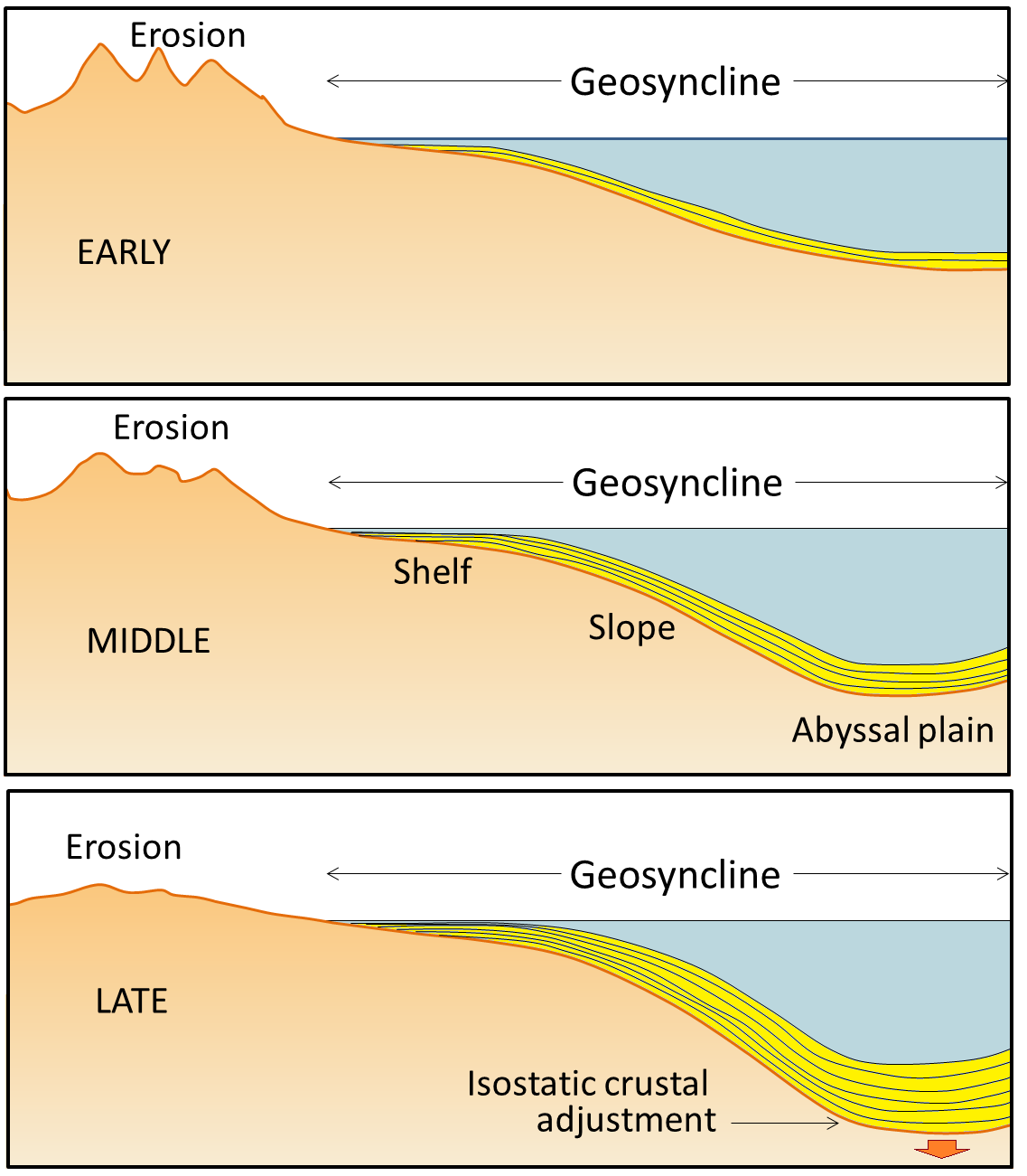
Another widely held view was permanentism, the idea that the continents and oceans have always been generally the same as they are today. This view incorporated a mechanism for creation of mountain chains known as the geosyncline theory. A geosyncline is a thick (potentially 1000s of metres) deposit of sediments and sedimentary rocks, typically situated along the edge of a continent, and derived from continental weathering (Figure 4.6).

The idea that geosynclines developed into fold-belt mountains originated in the middle of the 19th century. It was first proposed by James Hall and later elaborated upon by Dwight Dana, both of whom worked extensively in the Appalachian Mountains of the eastern United States. The process of converting a geosyncline into a mountain belt was believed to involve compression by forces pushing from either side, causing sedimentary layers within the geosyncline to fold up. In 1937, Philip Kuenen published a paper of experiments with layers of paraffin wax to test how this might work. He was able to cause layers within a geosyncline to fold up as the geosyncline deepened and became more tightly folded during the experiment (Figure 4.7).
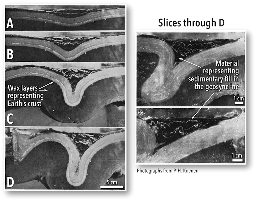
The problem with the geosynclinal hypothesis for mountain building is that the lateral forces required to cause the compression were never adequately explained. Kuenen compressed the wax layers in his experiment by using pistons that pushed horizontally from either side, but described that mechanism as unrealistic. He explained that the pistons were just to get the process started within the experiment, and that in nature the main force was likely that of gravity pulling the geosyncline downward, drawing the sides together as it folded. When the sides were drawn together, this provided the compression to fold the sediments within the geosyncline. He couldn’t specify how the process got started in nature, but suggested that there could be a variety of reasons for an irregularity in the crust to respond to forces in such a way that would trigger downward sagging and folding.
Proponents of the geosyncline theory of mountain formation—and there were many well into the 1960s—also had the problem of explaining the intercontinental terrestrial fossil matchups. The explanation offered was that land bridges had once linked the continents, permitting animals and plants to migrate back and forth. One proponent of this idea was the American naturalist Ernest Ingersoll. Referring to evidence of past climate changes, Ingersoll contributed the following to the 1918-20 edition of the Encyclopedia Americana:
The most interesting feature of these changes, however, is that by which, now and again, the Old World was connected with the New by necks or spaces of land, known as “land-bridges”; especially as these permitted an interchange of plants and animals, giving to us many new ones from the other side of the ocean, including, finally, man himself.
A problem with the land-bridge hypothesis is that there is no evidence of land bridges that could account for the fossil distribution patterns. The world’s oceans are approximately 4 km deep on average, so the underwater slopes leading up to a land bridge would have to have been at least 10s of km wide in most places, and many times that in others. Even if flooded, a land bridge of that size would still be visible in the shape of ocean-floor terrain. Isostasy would not permit such a land bridge to sink down without leaving a trace.
We do know the locations of some past land bridges, but they were very different from the ones that would be required for this hypothesis. They are bridges such as the flooded Bering Strait land bridge, which is beneath only 30 to 50 m of water, and was exposed when sea levels were much lower because of water being locked in polar ice caps during the last major glaciation event. The narrowest point of the Bering Strait is 82 km wide. The shortest distance between South America and Africa is more than 2800 km.
Exercise: Fitting the Continents Together
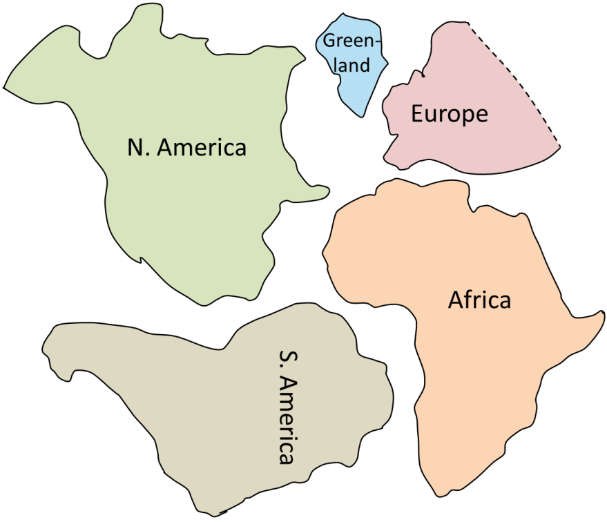
The main continents around the Atlantic Ocean are shown in Figure 4.8 with the shapes that they might have had during the Mesozoic, including the extents of their continental shelves. Cut these shapes out and see how well you can fit them together in the positions that these areas occupied within Pangea. Refer to a map of Pangea to help you make the fit. Note that the fit of the continents is even better than this, as distortions are introduced when rendering Earth onto a flat map. A better fit could be accomplished if you were to do this exercise upon the surface of a globe.
References
Ingersoll, E. (1919). Land-Bridges Across the Oceans. In The Encyclopedia Americana (Vol. XVI, pp. 692-694). New York, NY: Encyclopedia Americana Corporation. Full text
Kuenen, P. H. (1937) The negative isostatic anomalies in the East Indies (with Experiments). Leidse Geologische Mededelingen 8(2), 169-214. Full text
