
11.5 Plate Tectonics and Volcanism
Thus far volcanoes have been discussed in terms of the kinds of volcanic mountains they form, the materials they produce, and the style of eruption they have. All of these characteristics can be tied together into a big picture by considering the plate tectonic settings in which magma forms (Figure 11.32). The vast majority of volcanoes are present along plate tectonic boundaries.
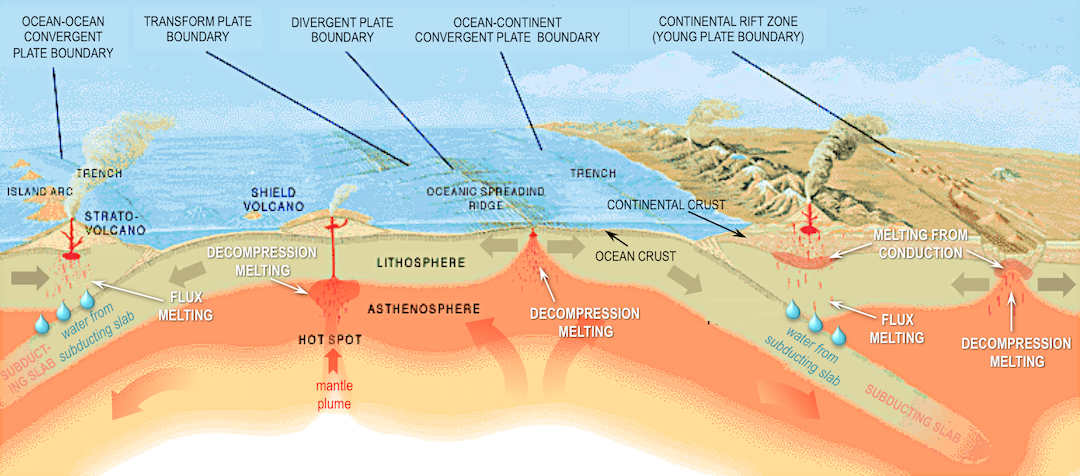
There are four main scenarios to consider:
- Divergent boundaries where melting is triggered by decompression
- Subduction zones (ocean-ocean and ocean-continent convergent boundaries) where flux melting occurs as water is released from subducting ocean crust
- Hot spots where plumes of hot mantle material rise up, then melt as a result of decompression.
- Melting by conduction when magma transfers heat to rocks having a lower melting temperature.
Decompression Causes Volcanism Along Spreading Centres and Rift Zones
At an ocean spreading ridge (centre of Figure 11.32), convection moves hot mantle rock slowly upward at rates of cm per year. At roughly 60 km below the surface, the mantle rocks have decompressed is enough to permit partial melting of approximately 10% of the ultramafic rock. Mafic magma is produced, and it moves up toward the surface. Magma fills vertical fractures produced by the spreading and spills out onto the sea floor making pillow lavas and lava flows. Spreading-ridge volcanism is taking place approximately 200 km offshore from the west coast of Vancouver Island.
In continental rift zones where continental crust is thinning (far right in Figure 11.32), a similar decompression process occurs, triggering partial melting of ultramafic mantle rocks. However, if the continental crust above the region where melting occurs has a lower melting temperature than the mafic melt that is produced, the continental crust will also melt.
Continental rift zones can have a range of volcano types. If mafic magma erupts, shield volcanoes, broad lava flows, and cinder cones result. However, if rocks of other compositions are melted and added in, or the mafic magma undergoes fractional crystallization before erupting, then composite volcanoes will also form.
Water Causes Partial Melting Along Subduction Zones
At an ocean-continent convergent boundary (Figure 11.32, right) or ocean-ocean convergent boundary (Figure 11.32, left), oceanic crust is pushed down into the mantle. Although temperatures are high, the slab is kept from melting by high pressures. However, under these conditions minerals in the slab release water from within their crystal structures. The water lowers the melting point of rock above the slab, and partial melting is triggered within the mantle. Mafic magma rises through the mantle to the base of the crust. There it contributes to partial melting of crustal rock, and more felsic material is added to the magma. The magma, now intermediate in composition, continues to rise and assimilate crustal material. In the upper part of the crust, it accumulates into plutons. Over time, fractional crystallization of magma within the pluton can make it even more silica-rich. From time to time, the magma from the plutons rises toward surface, leading to volcanic eruptions.
Composite volcanoes with Vulcanian or Plinian eruption styles are characteristic of the volcanic arcs that form in subduction zones, although in the Trans-Mexico Volcanic Belt, Strombolian eruptions produce short-lived cinder cones. Where two margins of oceanic crust collide, the volcanic arc will be a chain of volcanic islands. Where continental and oceanic crust collide, there will be a volcanic arc on the continental crust.
Mt. St. Helens: A Composite Volcano in the Cascades Range Continental Volcanic Arc
On May 18, 1980 at 8:32 a.m., a M5.1 earthquake shook Mt. St. Helens, and marked the start of a 9-hour Plinian eruption (Figure 11.33) with a 24 km high eruption column and multiple pyroclastic flows. By the time the eruption was over, a large part of the volcano had been blasted away.
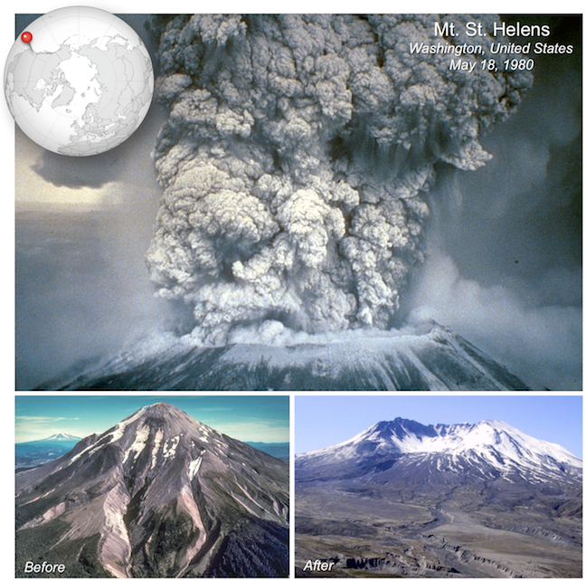
The explosive eruption was driven by gas-rich rhyolitic magma, however not all of Mt. St. Helens’ eruptions have been of felsic or intermediate material. The lava tube in Figure 11.10 (bottom) is from a time when Mt. St. Helens erupted basaltic lava. Data from the iMUSH (Imaging Magma Under St. Helens) project show that a magma chamber is present beneath Mt. St. Helens at between 5 and 14 km depth, but that a much larger magma chamber is present below it, which extends down to the mantle (Figure 11.34). Earthquakes in the 24 hours after the 1980 eruption suggested movement of magma within the smaller chamber (yellow arrows in Figure 11.34), but earthquakes from 1980 to 2005 indicate movement of magma within the deeper chamber as well (black arrows).
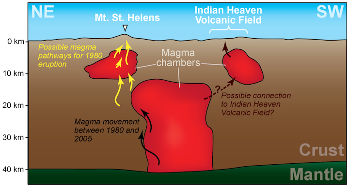
The complex history of Mt. St. Helens could reflect changes in the composition of magma within the small chamber over time, as fractionation proceeds, and the magma becomes more silica rich. However, movement of more mafic magma from the larger chamber could also contribute to eruptions with different chemical compositions. The larger magma chamber may be connected to a chamber feeding the nearby Indian Heaven Volcanic Field, which contains shield volcanoes and cinder cones, and for which basalt makes up 80% of erupted materials.
Mantle Plumes Can Cause Volcanism Away from Plate Boundaries
Mantle plumes are rising columns of hot solid rock. The column may be kilometres to 10s of kilometres across, but near the surface it spreads out to create a mushroom-like head that is 10s to over 100 kilometres across. Mantle plumes are different from the convection that normally occurs beneath ocean spreading centres: plumes rise approximately 10 times faster than mantle convection normally occurs, and may originate deep in the mantle, possibly just above the core-mantle boundary.
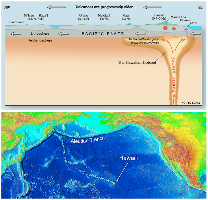
When the mantle plume rises to the base of the lithosphere, the pressure is low enough to permit partial melting of the plume material, producing mafic magma. Heat carried by the mantle plume may also melt rock adjacent to the plume. The magma rises and feeds hotspot volcanoes. The lithospheric plate above the mantle plume is moving across the plume, so a chain of hotspot volcanoes can result as existing hotspot volcanoes are slowly moved away from the mantle plume, and new volcanoes form in the lithosphere.
Many shield volcanoes are associated with mantle plumes, including those that make up the Hawai’ian islands. All of the Hawai’ian volcanoes are related to the mantle plume that currently lies beneath Mauna Loa, Kilauea, and Lōʻihi (Figure 11.35, top). There is evidence of crustal magma chambers beneath all three active Hawai’ian volcanoes. At Kīlauea, the magma chamber appears to be several kilometres in diameter, and is situated between 8 km and 11 km below surface (Lin et al., 2014). In this area, the Pacific Plate is moving northwest at a rate of about 7 cm/year. This means that the earlier formed — and now extinct — volcanoes have now moved well away from the mantle plume. The hotspot has in fact been present for at least 85 million years (Regelous et al., 2003), as evidenced by the long chain of eroded and submerged mountains stretching to the Aleutian Trench (Figure 11.35, bottom).
Kīlauea Volcano is approximately 300 ka old, while neighbouring Mauna Loa Volcano is over 700 ka and Mauna Kea Volcano is over 1 Ma. If volcanism continues above the Hawaii mantle plume in the same manner that it has for the past 85 Ma, it is likely that Kīlauea Volcano will continue to erupt for at least another 500,000 years. By that time, its neighbour, Lōʻihi Seamount, will have emerged from the sea floor, and its other neighbours, Mauna Loa and Mauna Kea, will have become significantly eroded, like their cousins, the islands to the northwest.
Large Igneous Provinces (LIPs)
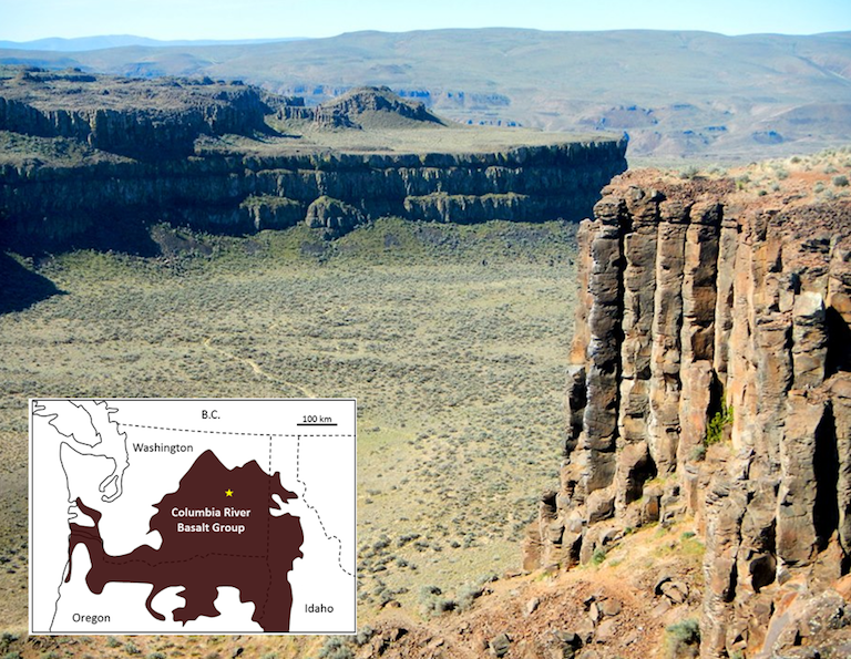
While the Hawaii mantle plume has produced a relatively low volume of magma for approximately 85 Ma, other mantle plumes are less consistent, and some generate massive volumes of magma over relatively short time periods. Although their origin is still controversial, it is thought that the volcanism leading to large igneous provinces (LIPs) is related to very high volume but relatively short duration bursts of magma from mantle plumes. An example of an LIP is the Columbia River Basalt Group, which extends across Washington, Oregon, and Idaho in the United States (Figure 11.36). This volcanism, which covered an area of about 160,000 km2 with basaltic rock up to several hundred metres thick, took place between 17 and 14 Ma.
The mantle plume that is assumed to be responsible for the Columbia River LIP is now situated beneath the Yellowstone area, where it leads to felsic volcanism. Over the past 2 Ma, three very large explosive eruptions at Yellowstone have yielded approximately 900 km3 of felsic magma. This is approximately 900 times the volume of the 1980 eruption of Mt. St. Helens, but only 5% of the volume of mafic magma in the Columbia River LIP.
Most other LIP eruptions are much bigger. The Siberian Traps (also basalt), which erupted at the end of the Permian period at 251 Ma, are estimated to have produced approximately 40 times as much lava as the Columbia River LIP. The largest known LIP is the Ontong Java Plateau, located in the southwest Pacific Ocean. It formed at around 122 Ma, and presently covers 1,500,000 km2 and has a volume of 5,000,000 km3. But this is only a small fraction of its original size. The majority of it has been subducted, and it may have been split into pieces that have been classified as separate LIPs.
Kimberlites
Kimberlite pipes are carrot-shaped cones of ultramafic rock. They form from the explosive eruption of mantle plumes originating at depths of 150 to 450 km in the mantle. The plume makes its way to the surface quickly (over hours to days), having little interaction with the surrounding rocks, and thus preserving a sample of the ultramafic mantle. As the plume nears the surface, a build-up of gas causes it to pick up speed, and by the time it reaches the surface it may be travelling faster than the speed of sound. The explosiveness of kimberlite eruptions means that they do not form volcanic mountains on the surface, but leave circular holes in the ground.
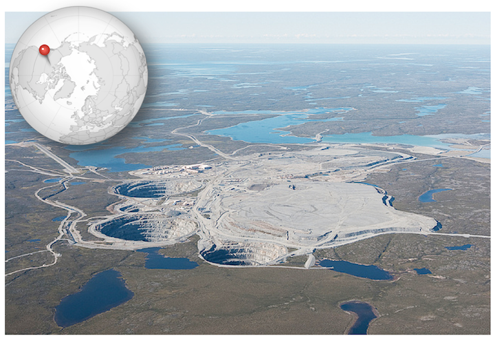
Kimberlite eruptions that originate at depths greater than 200 km beneath old, thick, continental crust travel through the region of the mantle where diamond is stable. In some cases, such as in Saskatchewan and the Northwest Territories, kimberlites bring diamond-bearing material to the surface. All of Earth’s diamond deposits are thought to have originated in this way.
Diamond mines in kimberlites, such as the Ekati Mine in the Northwest Territories, are easy to spot by the characteristic circular hole that develops as miners excavate the cone-shaped structure (Figure 11.37). The kimberlites at Ekati erupted between 45 and 60 Ma. Many kimberlites are older, and some much older. There have been no kimberlite eruptions in historic times. The youngest known kimberlites are in the Igwisi Hills in Tanzania and are only about 10,000 years old. The next youngest date to approximately 30 Ma.
References
Kiser, E., Palomeras, I., Magma reservoirs from the upper crust to the Moho inferred from high-resolution Vp and Vs models beneath Mount St. Helens, Washington State, USA. Geology (44)6, 411-414.
Lin, G, Amelung, F, Lavallee, Y, and Okubo, P. (2014). Seismic evidence for a crustal magma reservoir beneath the upper east rift zone of Kilauea volcano, Hawaii. Geology, 42(3), 187-190. DOI: 10.1130/G35001.1
Regelous, M., Hofmann, A. W., Abouchami, W., & Galer, S. J. G. (2003) Geochemistry of lavas from the Emperor Seamounts, and the geochemical evolution of Hawaiian magmatism from 85 to 42 Ma. Journal of Petrology 44(1), 113-140. DOI: 10.1093/petrology/44.1.113 view PDF
U. S. Geological Survey, Volcano Hazards Program (n.d.). Indian Heaven Volcanic Field visit website
U. S. Geological Survey, Volcano Hazards Program (n.d.). Mount St. Helens: 1980 Cataclysmic Eruption visit website
