
12.3 Earthquakes and Plate Tectonics
Bands of earthquakes trace out plate boundaries (coloured dots, Figure 12.16). The depths of earthquakes, and the width of the band, depend on the type of plate boundary. Mid-ocean ridges and transform margins have shallow earthquakes (usually less than 30 km deep), in narrow bands close to plate margins. Subduction zones have earthquakes at a range of depths, including some more than 700 km deep. Bands of earthquakes are wider along subduction zones because they take place throughout the subducting slab that extends beneath the opposing plate. Wide swaths of scattered earthquakes may correspond to continent-continent collision zones, such as between the Eurasian plate and the African, Arabian, and Indian plates to the south. Wide swaths of scattered earthquakes may also correspond to continental rift zones, such as in eastern Africa.
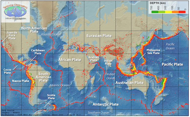
Earthquakes are also relatively common at a few locations away from plate boundaries. Some are related to the buildup of stress due to continental rifting or the transfer of stress from other regions, and some are not well understood. Locations include the Great Rift Valley area of Africa, the Lake Baikal area of Russia, and Tibet.
Earthquakes at Divergent and Transform Plate Boundaries
Earthquakes along divergent and transform plate margins are shallow (usually less than 30 km deep) because below those depths, rock is too hot and weak to avoid being permanently deformed by the stresses in those settings. If deformation is permanent, then removing the stress does not result in the rocks snapping back to their original shape. No snapping back means no shaking.
Mid-ocean ridge divergent plate margins are offset by numerous transform faults (Figure 12.17). The locations of earthquakes along mid-ocean ridges, and the mechanisms for causing them, depend on how rapidly the mid-ocean ridges are spreading. The Pacific-Antarctic Ridge (left) is spreading relatively rapidly at 42 to 94 mm/year, depending on the location along the ridge. Rapid spreading causes rocks near the axis of the spreading centre to be hot and weak. As a result, most of the earthquakes (white dots) are located along transform faults, where rocks are cooler and stronger. Along rapidly spreading ridges, new ocean crust is bent upward into wide, high ridges. As spreading proceeds and crust moves away from the ridge, the bend is relaxed, and the crust stretches and breaks. This triggers earthquakes many kilometres away from the ridge.
The Southwest Indian Ridge (right) spreads very slowly, at approximately 14 mm/year. Rocks are cooler and stronger along the slowly spreading ridge than along the rapidly spreading one. In the slow-spreading environment, earthquakes are generated when rocks along the ridge axis stretch and break. Earthquakes are more evenly distributed between divergent and transform segments of the boundary than they are along fast-spreading ridges.
Earthquakes in continental rift zones are also shallow, but scattered more broadly than those along mid-ocean ridges. Lake Baikal (Figure 12.28), the world’s oldest, deepest, and largest freshwater lake, formed 25 million years ago because of continental rifting. Note the scale in Figure 12.18, and compare how widely the earthquakes (blue dots) are spread in the Lake Baikal region, versus along the mid-ocean ridges in Figure 12.17.

One reason for the difference in earthquake distribution in continental rift zones is that the rifts are only beginning to form. Faulting is “disorganized” within the continental crust. There is no well-established spreading centre, unlike mid-ocean ridges. Another reason is that the locations of faults, and thus earthquakes, in continental rift zones are affected by pre-existing geological structures within continental crust. In the case of the Lake Baikal rift, the strong, ancient crust of the Siberian Craton influences the orientation of the faults forming the rift. Faults run parallel to the craton near Lake Baikal. As rifting extends to the east, the part of the craton in the upper right of Figure 12.18 may deflect rifting southward.
Earthquakes at Convergent Boundaries
Subduction Zones
Along convergent plate margins with subduction zones, earthquakes range from shallow to depths of up to 700 km. Earthquakes occur where the two plates are in contact, as well as in zones of deformation on the overriding plate, and along the subducting slab deeper within the mantle. The result is that epicentres of earthquakes farther to the interior of the overriding plate will correspond to increasingly deep earthquakes.
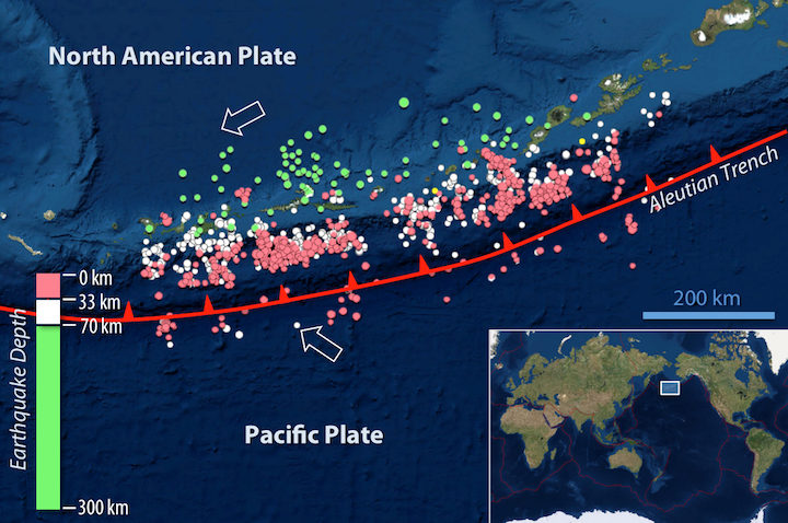
Where the Pacific plate subducts beneath the North American plate, forming the Aleutian volcanic arc (Figure 12.19), earthquakes increase in depth moving northward, following the Pacific plate into the mantle. Earthquakes between 0 and 33 km deep (red circles) occur closest to the subduction zone (red line; teeth point in the direction of the subducting slab). While there is some overlap, earthquakes between 33 and 70 km deep (white circles) occur in a band that reaches farther the north. Farthest north are the epicentres for earthquakes between 70 and 300 km deep (green dots). The deepest earthquake during the seven year interval shown in Figure 12.19 is represented by the large green dot farthest to the north. It occurred at a depth of 265 km.
Earthquakes occur in subduction zones for a variety of reasons. Stresses associated with the collision of two plates cause deformation in the overriding plate, and thus shallow earthquakes. Shallow earthquakes also happen on the subducting slab when a locked zone (orange line, Figure 12.20) ruptures. The locked zone is where the largest earthquakes on Earth, called megathrust earthquakes, occur. There is the potential for a wider rupture zone on a gently dipping subduction zone boundary compared to other boundaries.
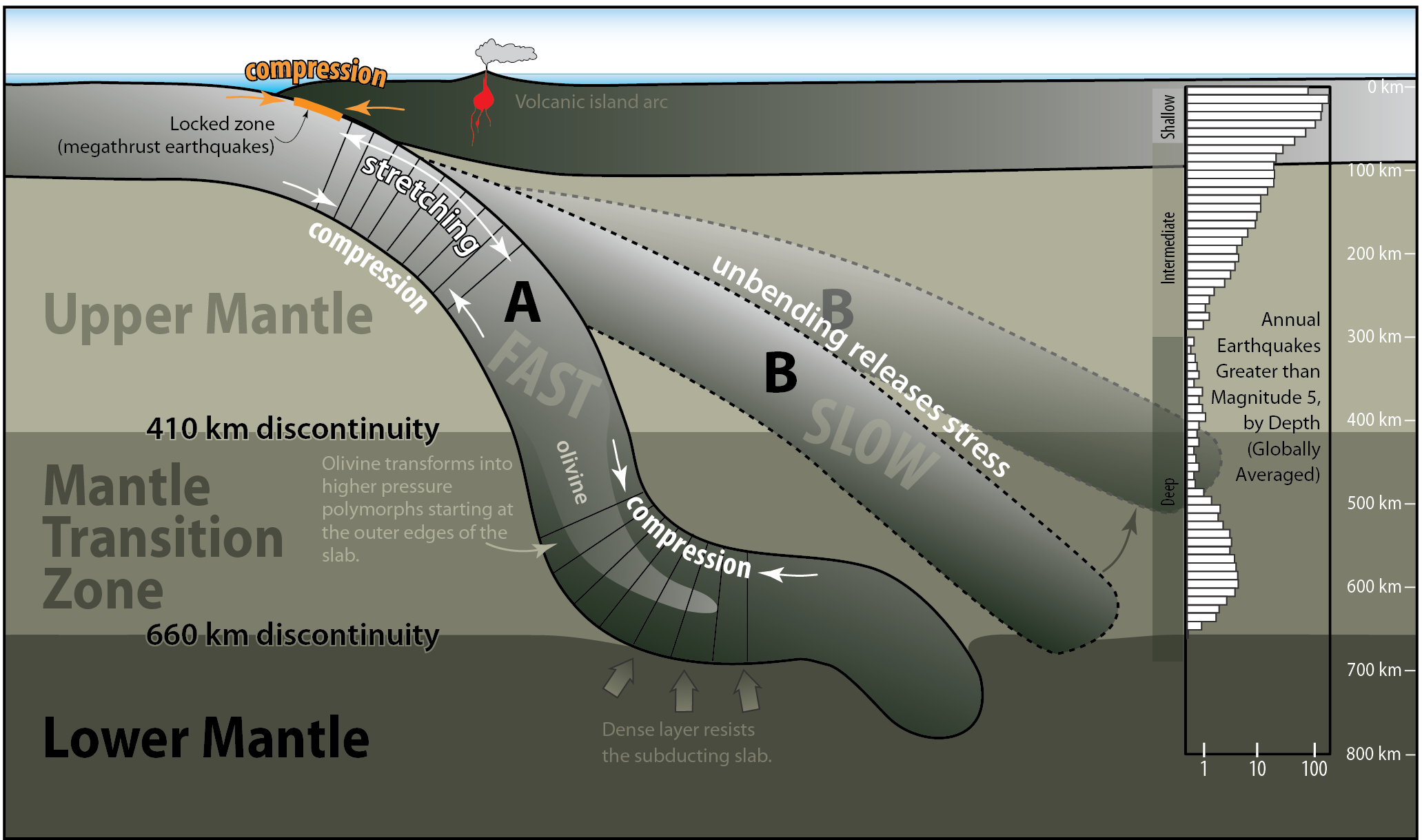
If subduction is rapid, the subducting plate will bend more as it enters the mantle (slab A in Figure 12.20), causing the upper edge of the plate to stretch, and the interior and lower edge to be compressed. Stress from bending can cause shallow to intermediate earthquakes on these plates. Even without bending, the subducting slab can become stretched by its own weight as it falls into the mantle.
The 410 km and 660 km discontinuities in Figure 12.20 mark boundaries where minerals transform into other, denser minerals that are stable at higher pressures and temperatures. When the subducting slab reaches the 660 km discontinuity (the top of the lower mantle), the increase in density in the surrounding mantle may slow down the leading edge of the sinking slab. Earthquakes can be generated when the slab is compressed by the lower mantle resisting its motion at the same time that the upper part of the slab continues to fall.
Slower rates of subduction mean that the subducting slab will enter the mantle at a lower angle (slab B in Figure 12.20). These slabs might not have earthquakes from being bent downward into the mantle, as with slab A, but earthquakes may be triggered by changes in stress if the plate relaxes and unbends.
The bar chart on the right of Figure 12.20 shows global average number of earthquakes that occur at different depths. Earthquakes are most abundant at the surface, and then fall to a minimum at 300 km. The number of earthquakes remains low until almost 500 km depth, and reaches a second peak around 600 km depth. The second peak might be explained by interactions between the subducting plate and the dense mantle beneath the 660 km discontinuity, but another hypothesis is that it is related to delayed mineral transformations. The subducting slab warms as it goes deeper into the mantle, but the warming is not uniform. The outer edges of the slab will warm before the interior does. The 410 km discontinuity is where olivine is transformed into the minerals wadsleyite and ringwoodite under normal mantle pressure and temperature conditions. However, if the interior of the subducting slab is still too cool at that depth, olivine will be retained to depths below 410 km. Olivine weakens prior to transforming into the high pressure minerals, and the weakening may make it easier for the slab to rupture.
Continent-Continent Convergence Zones
Where continents collide, earthquakes are scattered over a much wider area compared to earthquakes along mid-ocean ridges, transform margins, or subduction zones. An example is where the Indian plate collides with the Eurasian plate (Figure 12.21). At one time, India was a separate continent, and ocean crust separated India from the Eurasian plate. For a time, a subduction zone existed where ocean lithosphere from the Indian plate subducted beneath the Eurasian plate. But when the two land masses finally met, they became locked together and the subduction zone was closed off. Today the Indian plate is still pushing against the Eurasian plate in the regions indicated by the red arrows in Figure 12.21. The collision is accommodated by transform boundaries along the Indian plate. Regions of overall transform motion are indicated in Figure 12.21 with blue arrows.
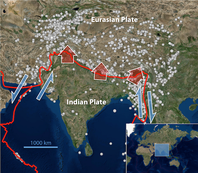
The majority of earthquakes in Figure 12.21 occur at depths less than 70 km, however they are still abundant down to 150 km, and extend to more than 300 km depth at some locations. Deeper earthquakes may be caused by continued northwestward subduction of part of the Indian plate beneath the Eurasian plate in this area. Even though the area is no longer a subduction zone, the subducted slab still remains, and is subject to stresses that can trigger earthquakes.
Some of the earthquakes in Figure 12.21 are related to the transform faults on either side of the Indian plate, and most of the others are related to the squeezing caused by the continued convergence of the Indian and Eurasian plates. That squeezing has caused the Eurasian plate to be thrust over the Indian plate, building the Himalayas and the Tibet Plateau to enormous heights. Most of the earthquakes of Figure 12.21 are related to the thrust faults shown in Figure 12.22 (and to hundreds of other similar ones that cannot be shown at this scale). The southernmost thrust fault in Figure 12.22 (the Main Boundary Fault) is equivalent to the convergent boundary in Figure 12.21.

Intraplate Earthquakes
Intraplate earthquakes (within-plate earthquakes) are those that occur away from plate boundaries. Some intraplate earthquakes are related to human activities. When humans trigger earthquakes it is referred to as induced seismicity. In Saskatchewan there have been 20 earthquakes since 1985 (all less than magnitude 4), and the majority occurred near potash mines. Excavation changes the stress in surrounding rocks, so earthquakes may occur in the rocks above excavated parts of the mine. In Alberta, induced seismicity is triggered by hydraulic fracturing operations when water pressure increases along existing faults, causing them to slip.
Intraplate earthquakes not related to human activities often occur along ancient rift zones. In eastern Canada, the Charlevoix seismic zone (approximately 100 km northeast of Québec City; Figure 12.23), is associated with a rift-zone faults that developed when an ancient ocean basin began to form more than 500 million years ago. Coincidentally, the rocks of the Charlevoix Seismic Zone are also fragmented because of a meteorite impact (the crater margin is indicated by the blue circle in Figure 12.23), weakening them further. While the Charlevoix zone is far from any boundary of the North American plate, tectonic forces acting on plate boundaries are still transmitted to the interior of the continent, contributing to the stress that causes the faults along the rift zone to rupture.
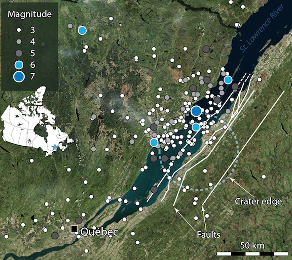
Intraplate earthquakes can be large earthquakes. The Charlevoix seismic zone has had five earthquakes of magnitudes between 6 and 7 since 1663. The New Madrid seismic zone in the Mississippi River Valley had a series of four earthquakes with magnitudes between 7 and 8 in the winter of 1811-1812. The population of the region was sparse at the time, but today there are major cities in the New Madrid seismic zone, including Memphis, Tennessee, and St. Louis, Missouri.
References
Buck, W. R., Lavier, L. L., & Poliakov, A. N. B. (2005). Modes of faulting at mid-ocean ridges. Nature 434(7034), 719-23. doi: 10.1038/nature03358
Coastal and Marine Geology Program, U. S. Geological Survey (n.d.). Lake Baikal – A Touchstone for Global Change and Rift Studies. Visit website
DeMets, C., Gordon, R. G., & Argus, D. F. (2010). Geologically current plate motions. Geophysical Journal International 181, 1-80. doi: 10.1111/j.1365-246X.2009.04491.x
Earthquakes Canada, Natural Resources Canada (2016) Earthquake zones in Eastern Canada Visit website
