
17.3 Glacial Deposits
Sediments transported and deposited during glaciations are abundant throughout Canada. They are important sources of aggregate for construction materials (sand, gravel), and are also important groundwater reservoirs. Because they are almost all unconsolidated, they have significant implications for slope stability and mass wasting.
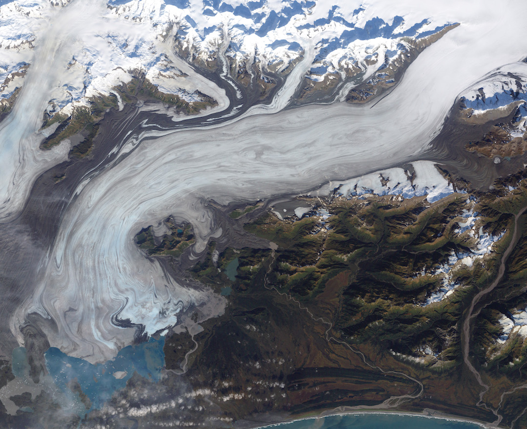
Figure 17.26 illustrates some of the ways that sediments are transported and deposited by alpine glaciers. The Bering Glacier is the largest glacier in North America, and although most of it is in Alaska, it flows from an icefield that extends into the southwestern Yukon Territory. The surface of the ice is partially, or in some cases completely, covered with rocky debris that has fallen onto the glacier from surrounding steep rock faces. There are muddy rivers issuing from the glacier in several locations, depositing sediment on land, into Vitus Lake, and directly into the ocean. Icebergs are portions of the glacier that have broken off and float away in a lake or ocean. Icebergs are laden with glacial sediments, which are released and deposited as the icebergs melt. Also, not visible in this view, there are sediments being moved along within and beneath the glacier itself.
Sediments are formed and transported in several ways in glacial environments (Figure 17.27). There are many different kinds of glacial sediments, which are generally classified by whether they are transported on, within, or beneath the glacial ice.
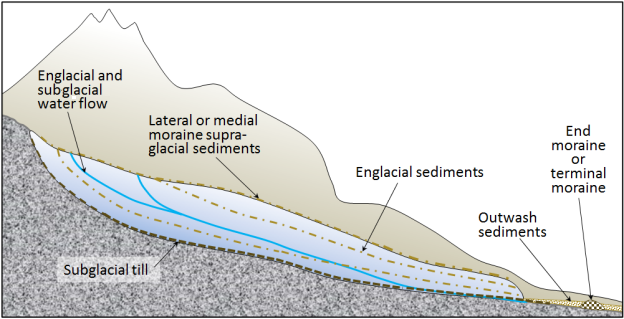
Supraglacial (on top of the ice) and englacial (within the ice) sediments are released from the melting front of a stationary glacier. These sediments can form a ridge of unsorted sediments called an end moraine. The end moraine from the furthest advance of a glacier is called a terminal moraine. The general name for any sediments transported and deposited by glacial ice is till.
Subglacial sediment (e.g., lodgement till) is material that has been eroded from the rock underlying the glacier by the ice and then transported by the ice. It has a wide range of grain sizes, including a relatively high proportion of silt and clay. The larger clasts (pebbles to boulders in size) tend to become partly rounded by abrasion. When a glacier eventually melts, the lodgement till is exposed as a sheet of well-compacted sediment ranging from several centimetres to many metres in thickness. Lodgement till is normally poorly sorted and does not contain bedding features like a lake or stream sediment (Figure 17.28).
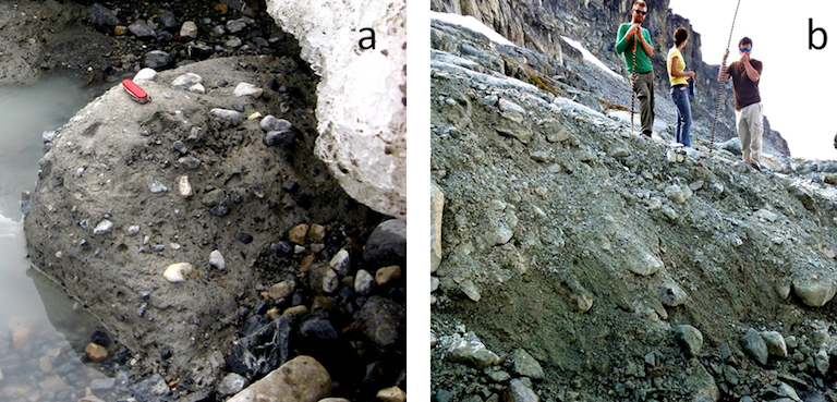
Supraglacial sediments are primarily derived from freeze-thaw eroded material that has fallen onto the ice from rocky slopes above. These sediments form lateral moraines (moraine deposits along the edges of the glacier, see Figure 17.1 for an example). Where two glaciers meet, the sediments form medial moraines (medial moraines are visible in Figure 17.20 and Figure 17.26.) Most of this material is deposited on the ground when the ice melts. This is called ablation till, a mixture of fine and coarse angular rock fragments, with much less sand, silt, and clay than lodgement till (Figure 17.28). When supraglacial sediments become incorporated into the body of the glacier, they are known as englacial sediments (Figure 17.27).
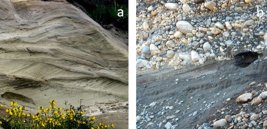
Water flows on the surface, within, and at the base of a glacier, even in cold areas and even when the glacier is advancing. Depending upon its velocity, this water is able to transport sediments of various sizes, and discharges most of these sediments out of the lower end of the glacier, where they are deposited as outwash sediments. These sediments accumulate in a wide range of environments in the proglacial region (the area in front of a glacier). Most of the sediments accumulate in fluvial environments, but some are deposited in lacustrine and marine environments. Glaciofluvial sediments are similar to sediments deposited in normal fluvial environments, but are glacially-derived sediments, and are thus dominated by silt, sand, and gravel. The grains tend to be moderately well rounded and sorted, and the sediments have similar sedimentary structures (e.g., bedding, cross-bedding, clast imbrication [overlapping]) to those formed by non-glacial streams (Figure 17.29).
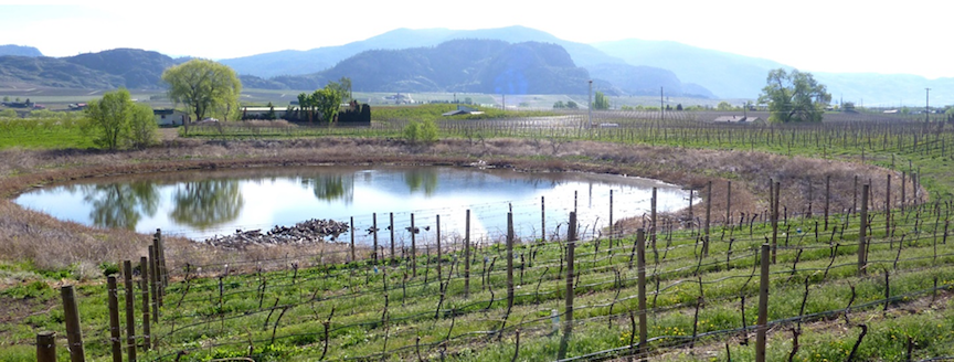
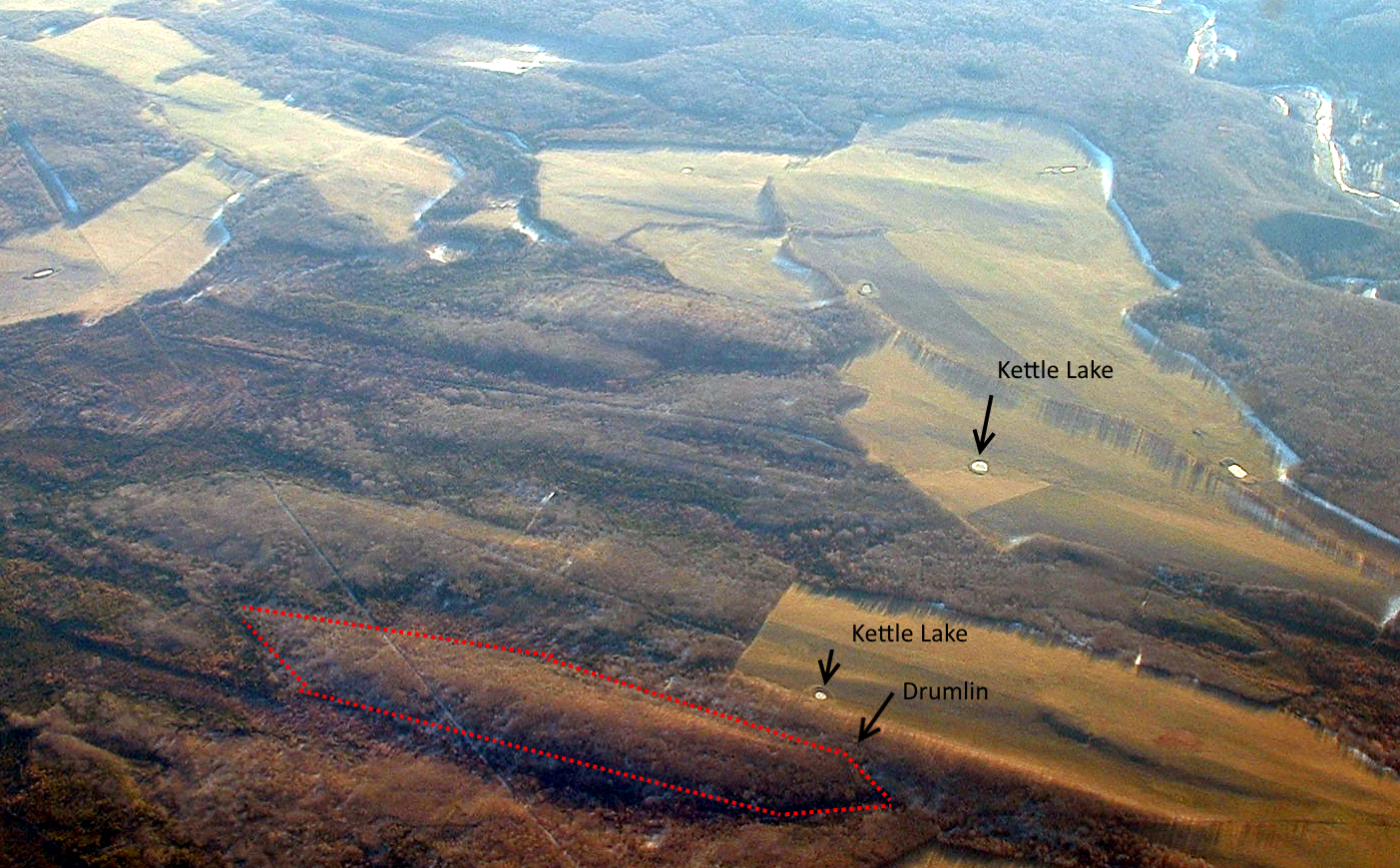
A large proglacial plain of sediment is called a sandur (aka outwash plain), and within this area, glaciofluvial deposits can be tens of metres thick. In situations where a glacier is receding, a block of ice might become separated from the main ice sheet and become buried in glaciofluvial sediments. When the ice block eventually melts, a depression forms, known as a kettle, and if this fills with water, it is known as a kettle lake (Figure 17.30, 17.32). Kettle lakes are also known as pothole lakes or prairie potholes.
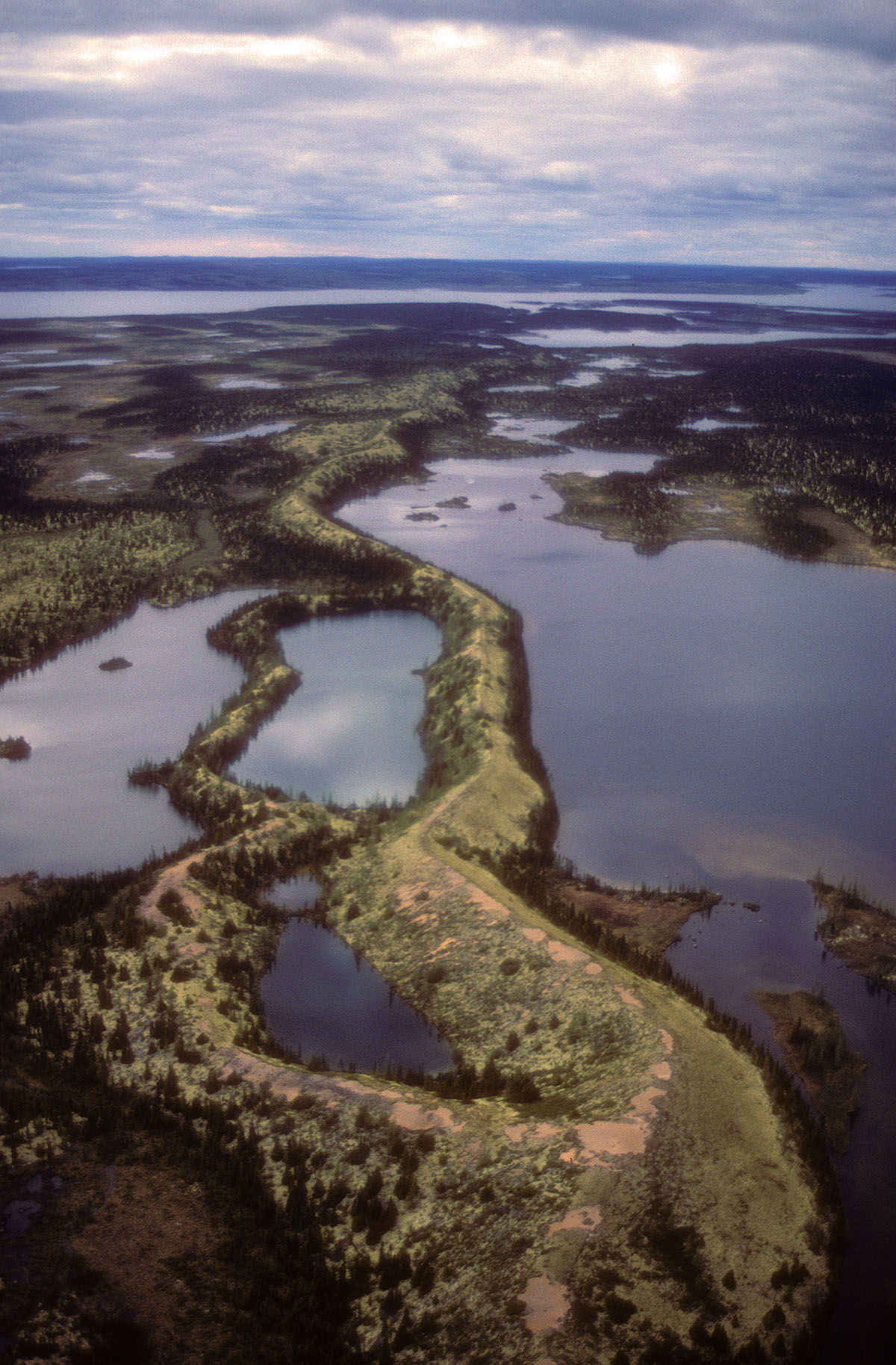
A supraglacial, englacial, or subglacial stream will create its own channel within the ice, and sediments that are being transported and deposited by the stream will build up within that channel. When the ice melts, the sediment will be deposited upon the underlying ground surface to form a long sinuous ridge known as an esker. Eskers are most common in areas of continental glaciation. They can be several metres high, tens of metres wide, and tens of kilometres long (Figure 17.31). Eskers are commonly comprised of well-sorted sands.
Drumlins are elongated, oval shaped ridges of englacial to subglacial sediments that form at the base of continental glaciers. They are often tens of metres high and hundreds of metres long, and often occur in clusters (“fields”) of tens to hundreds of drumlins (Figure 17.32). As the sediments are deposited, the glacier molds the drumlins’ shapes as the glacier moves over and around them. The long axis of a drumlin is aligned with the direction that the ice moved when the drumlin was deposited.
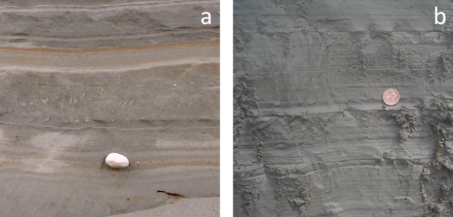
Glacial outwash streams commonly flow into proglacial lakes (lakes in front of glaciers) where glaciolacustrine sediments are deposited. These are dominated by silt- and clay-sized particles and are typically laminated (finely layered) on the millimetre scale. In some cases, varves develop. Varves are a series of beds with distinctive summer and winter layers: relatively coarse in the summer when melt discharge is high, and finer in the winter, when discharge is low. Icebergs are common in proglacial lakes, and most of them contain englacial sediments of various sizes. As the icebergs melt, the released clasts sink to the bottom and are incorporated into the glaciolacustrine layers as drop stones (Figure 17.33a). The processes that occur in proglacial lakes can also take place where a glacier terminates in the ocean. The sediments deposited there are called glaciomarine sediments (Figure 17.33b).
Exercise: Identifying Glacial Depositional Environments
Refer to the photo of the Bering Glacier in Alaska shown in Figure 17.26. Glacial sediments of many different types are being deposited throughout the region depicted in this photo.
Identify where you would expect to fine the following:
(a) glaciofluvial sand
(b) lodgement till
(c) glaciolacustrine clay with drop stones
(d) ablation till
(e) glaciomarine silt and clay
