
Chapter 12. Earthquakes
Adapted by Karla Panchuk from Physical Geology by Steven Earle
Learning Objectives
After reading this chapter, and answering the review questions at the end, you should be able to:
- Explain how elastic deformation of Earth’s crust results in earthquakes.
- Describe how the main shock and immediate aftershocks define the rupture surface of an earthquake, and explain how the transfer of stress to other parts of a fault is related to aftershocks.
- Explain the process of episodic tremor and slip.
- Explain how plate tectonic setting affects where earthquakes occur.
- Distinguish between an earthquake’s magnitude and its intensity, and explain how these are determined.
- Describe the hazards caused by earthquakes, including ground shaking, fires, slope failures, liquefaction, and tsunami.
- Explain how the risk of an earthquake can be assessed, and describe steps that governments and individuals can take to minimize the impacts of earthquakes.
Why Study Earthquakes?
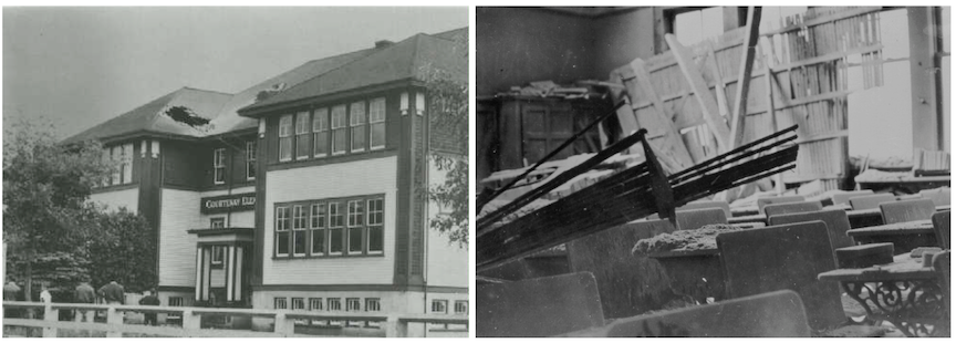
On the morning of June 23, 1946, a magnitude 7.3 earthquake struck Vancouver Island. It caused substantial damage to structures, including the school shown in Figure 12.2, and resulting in one fatality. The shaking was so violent that the seismograph measuring the earthquake in Victoria was broken a few seconds after the earthquake started. Even if the seismograph had survived, it was not sensitive enough to provide sufficiently detailed information about local earthquakes, and was unable to record some of them at all. There was only one monitoring station in British Columbia, so while it was possible to determine how far away the earthquake was from the station, geologists were not able to say in which direction. In 1955, Canadian seismologist W. G. Milne wrote that “the 1946 earthquake indicated in a very forceful manner the need for better instruments for the study of earthquakes in British Columbia.” A network of improved instruments was established as a direct result of the earthquake.
Time and time again earthquakes have caused massive damage and many, many casualties. Recording earthquakes and determining their location of origin is important for establishing what geological conditions are responsible for the earthquakes, and understanding the risk they pose. After new, more sensitive instruments were installed at the Dominion Astrophysical Observatory in Victoria, geologists quickly learned that they had underestimated earthquake activity in the area. Between June of 1948 and August of 1951, 224 local earthquakes were recorded!
By studying earthquakes, geoscientists and engineers are making progress toward learning how to minimize earthquake damage, and how to reduce the number of people affected by earthquakes. This knowledge can be communicated to governments, so they are aware of what is needed to keep the population safe. It can also be communicated to individuals, so they know what to expect and do in the event of an earthquake, and can be adequately prepared with emergency supplies.
Additional Resources
Detailed description of the effects of the 1946 earthquake: Hodgson, E. A. (1946). British Columbia Earthquake, June 23, 1946. The Journal of the Royal Astronomical Society of Canada XL(8), 285 – 319. Read the paper
References
Milne, W. G. (1955). Seismology in British Columbia. The Journal of the Royal Astronomical Society of Canada XLIX(4), 141 – 150. Read the paper
Ministry for Culture and Heritage (2017). Christchurch earthquake kills 185. Visit website
