
14.4 Stream Types
Stream channels can be straight or curved, deep or shallow, cleared or filled with coarse sediments. The cycle of erosion has some influence on the nature of a stream, but there are several other factors that are important.
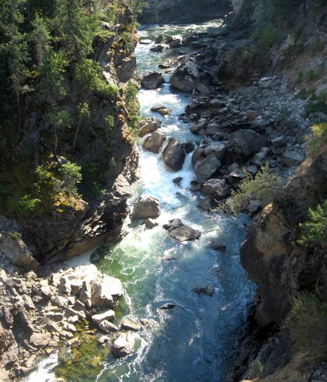
Youthful streams that are actively downcutting their channels tend to be relatively straight and are typically ungraded (meaning that rapids and waterfalls are common). As shown in Figures 14.1 and 14.20, youthful streams commonly have a step-pool morphology, meaning that the stream consists of a series of pools connected by rapids and waterfalls. They also have steep gradients, and steep and narrow V-shaped valleys. In some cases these valley walls are steep enough to be called canyons.
![Figure 13.18 The Cascade Falls area of the Kettle River, near Christina Lake, B.C. This stream has a step-pool morphology and a deep bedrock channel. [SE]](http://opentextbc.ca/geology/wp-content/uploads/sites/110/2015/08/Cascade-Falls-area.jpg)
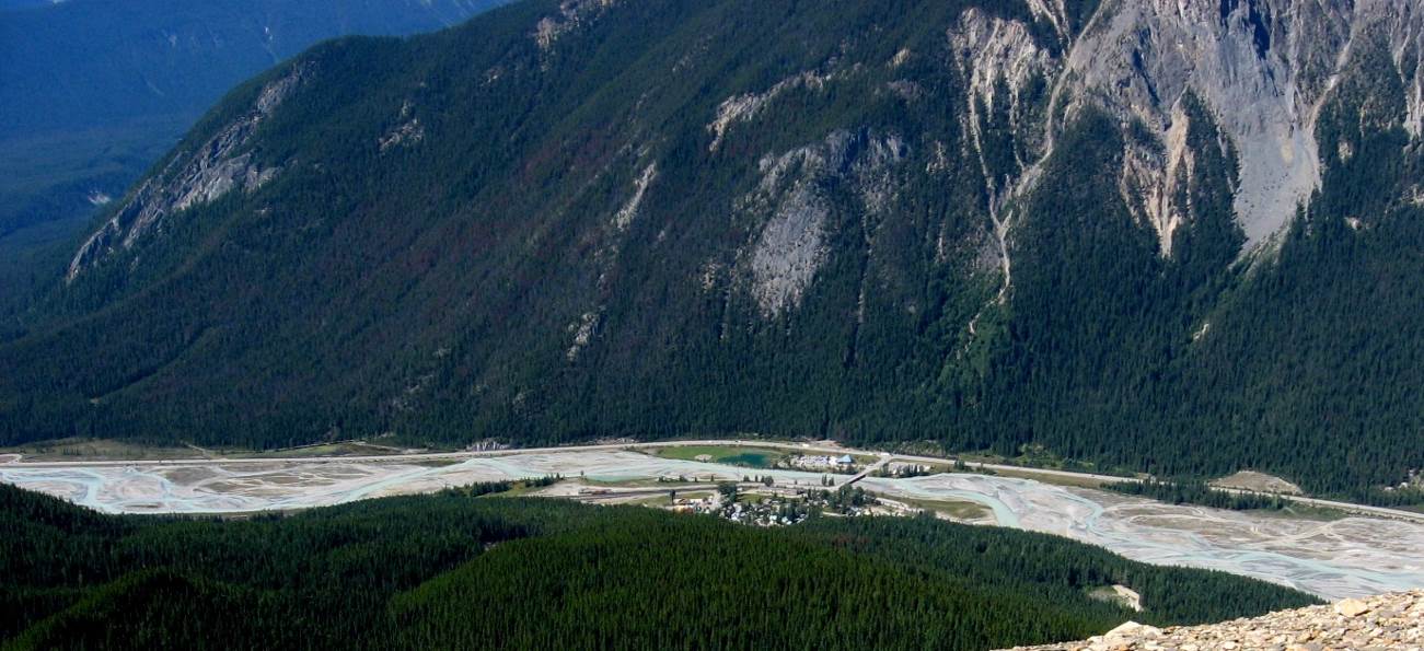
In mountainous terrain, such as that in western AB and BC, steep youthful streams typically flow into wide and relatively low-gradient U-shaped glaciated valleys. The youthful streams have high sediment loads, and when they flow into the lower-gradient glacial valleys where the velocity is no longer high enough to carry all of the sediment, braided stream patterns develop, characterized by a series of narrow channels separated by gravel bars (Figure 14.21).
![Figure 13.19 The braided channel of the Kicking Horse River at Field, B.C. [SE]](http://opentextbc.ca/geology/wp-content/uploads/sites/110/2015/08/Kicking-Horse-River.jpg)
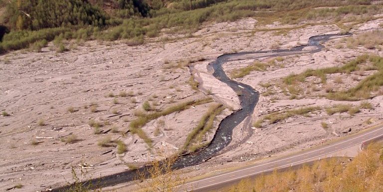
Braided streams can develop anywhere where there is more sediment than a stream is able to transport. One such environment is in volcanic regions, where explosive eruptions produce large amounts of unconsolidated material that gets washed into streams. The Coldwater River next to Mt. St. Helens in Washington State is a good example of such a braided stream (Figure 14.22).
![Figure 13.20 The braided Coldwater River, Mount St. Helens, Washington. [SE]](http://opentextbc.ca/geology/wp-content/uploads/sites/110/2015/08/Coldwater-River.jpg)
A stream that occupies a wide, flat flood plain with a low gradient typically carries only sand-sized and finer sediments and develops a sinuous flow pattern. As you saw in Figure 14.15, when a stream flows around a bend, the main current of the stream flows near the outside portion of the bend. This leads to erosion of the banks on the outside of the bend, and deposition of a point bar on the inside of the bend (Figure 14.23). Over time, the sinuosity of the stream becomes increasingly exaggerated, and the channel migrates throughout its flood plain, forming a meandering pattern.
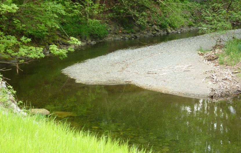
![Figure 13.21 The meandering channel of the Bonnell Creek, Nanoose, B.C. The stream is flowing toward the viewer. The sand and gravel point bar must have formed when the creek was higher and the flow faster than it was when the photo was taken. [SE]](http://opentextbc.ca/geology/wp-content/uploads/sites/110/2015/08/Bonnell-Creek.jpg)
A well-developed meandering river is shown in Figure 14.24. The meander in the middle of the photo has reached the point where the thin neck of land between two parts of the channel is about to be eroded through. When this happens, an oxbow lake will form. These are small cut off bends from earlier curves in the river; several are visible outside the path of the main stream in Figure 14.24.
![The meandering channel of the Nowitna River, Alaska. Numerous oxbow lakes are present and another meander cutoff will soon take place. [Oliver Kumis CC-BY-SA http://bit.ly/1SmQL7B]](http://opentextbc.ca/geology/wp-content/uploads/sites/110/2015/08/Nowitna-River.jpg)
At the point where a stream enters a body of water such as a lake or the ocean, the flow rates drops dramatically, and sediment is deposited. Over time, as more and more sediments are deposited, the sediments form a distinctive triangular shape (with the bottom broad part of the triangle facing the ocean or lake and the point of the triangle facing upstream). This is called a delta; these are named after the Greek letter delta which is in the shape of a triangle. The Fraser River has created a large delta in BC where the river meets the Strait of Georgia (Figure 14.25). Much of the Fraser delta is very young in geological terms. Shortly after the end of the last glaciation (10,000 years ago), the delta did not extend past New Westminster. Since that time, all of the land that makes up Richmond, Delta, and parts of New Westminster and south Surrey has formed from sediment depositing from the Fraser River. You can see a more detailed description of the Fraser delta on the Geoscape Vancouver website: http://www.cgenarchive.org/vancouver-fraserdelta.html
![The delta of the Fraser River and the plume of sediment that extends across the Strait of Georgia. The land outlined in red has formed over the past 10,000 years. [September 2011, SE after NASA http://bit.ly/FrasR]](http://opentextbc.ca/geology/wp-content/uploads/sites/110/2015/08/delta-of-the-Fraser-River.jpg)
Exercise 14.4 Calculating Stream Gradients
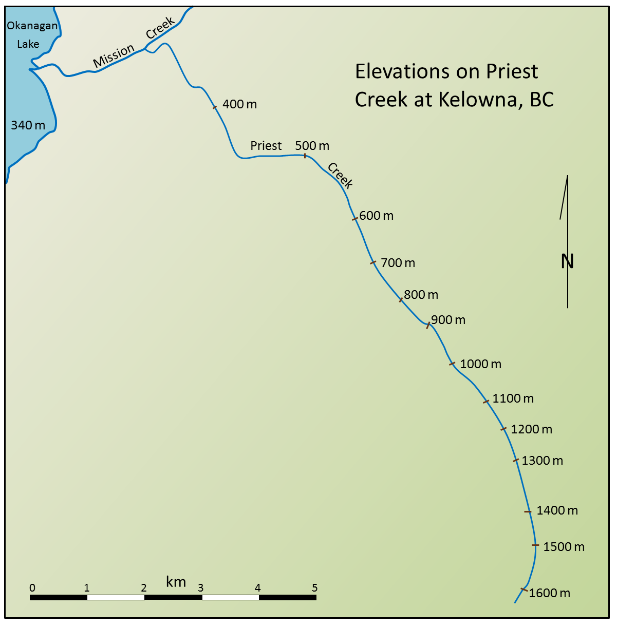
The gradient is the key factor controlling stream velocity, and stream velocity controls sediment erosion and deposition. This map shows the elevations of Priest Creek in the Kelowna area. The length of the creek between 1,600 m and 1,300 m elevation is 2.4 km, so the gradient is (1,600 m – 1,300 m)/2.4 km = 125 m/km.
- Use the scale bar to estimate the distance between 1,300 m and 600 m and calculate the gradient between these two elevations.
- Estimate the gradient between 600 and 400 m.
- Estimate the gradient between 400 m on Priest Creek and the point where Mission Creek enters Okanagan Lake.
