13.4 Mountain Building
Some of Earth’s mountains are entirely or almost entirely the result of volcanic activity. These include volcanic islands like the Hawai’ian hotspot volcanoes, and newly formed volcanic island arcs along subduction zones. But the majority of mountain building on Earth is the result of plate tectonic forces that deform Earth’s crust through faulting and folding. Mountain building through folding and faulting may or may not be supplemented by volcanic activity.
Mountain Building Along Convergent Margins
Mountain building along convergent margins is referred to as orogeny, and the mountains that are built are called orogens.
Ocean-Continent Collision
In ocean-continent collision zones, folding and faulting of rocks combines with volcanism to build mountains. An example of mountains built this way is the Sierra Nevada mountain range in Utah and Nevada. The orogeny that formed the Sierra Nevada range began around 140 million years ago.
The mountain range was built up by igneous intrusions and volcanic eruptions along a continental volcanic arc (Figure 13.32). The terrain was altered further inland as well. Sheets of rock were thrust on top of each other, and pushed inland along a detachment fault, similar to the example of the McConnell Thrust in Figure 13.29.

Continental crust flexed downward because of the weight of the mountains, and this formed a fore arc basin seaward of the new mountain range. Sediments accumulated within that basin. The leading edge of the continent also collected sediments and igneous rock scraped off the subducting plate, forming an accretionary wedge. Over time, the force of the collision would smash the basin sediments and the accretionary wedge against the continent, turning it into new continental crust.
Continent-Continent Collision
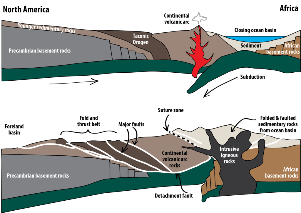
When two continents collide, it means the closure of a subduction zone, and an end to volcanism. The Alleghenian Orogeny, which brought together North America and Africa, helping to form Pangea, is an example of mountain building in a continent-continent collision zone. Before the continents came into contact with each other, mountain building on the eastern coast of North America would have involved deformation from an ocean-continent collision, as with Figure 13.32. But as subduction proceeded, the subducting plate drew Africa closer and closer to North America. The gap between the two continents began to close, and fill with sediments (Figure 13.33, top).

While a subduction zone existed, the addition of water to the mantle permitted partial melting of mantle rocks, and thus volcanic activity. However, when the two continents collided, the subduction zone closed off and volcanism was no longer possible. As the continents smashed together, deep faults formed and stacked blocks of crust on top of each other. Old faults were reactivated. Rocks also began to shift along the boundary between an earlier orogen, the Taconic Orogen, and North America (Figure 13.33, bottom). When the continents had finally merged, Africa met North America along a suture zone with remnants of a continental volcanic arc on one side, and folded and faulted sedimentary rocks on the other.
Mountain Building Along Divergent Margins
When continents begin to split apart, normal faults form. This can lead to large blocks of crust that are tilted, raised, or lowered compared to adjacent blocks. Blocks that are elevated compared to adjacent blocks can form another type of mountain, called a fault-block mountain. Fault block mountains formed in eastern North America when Pangea began to split up, and Africa pulled away from North America (Figure 13.34).

Over time, elevated blocks erode, filling up valleys with sediment. The thinning of continental crust that occurs with rifting can decrease the pressure on mantle rocks enough to trigger partial melting. Magma can move up along the normal faults, forming igneous intrusions, or feeding volcanoes. The Palisades Sill in New York and New Jersey is a result of rift-zone magmatism. It is a cliff-like feature resulting from erosion that exposed the tip of a structure like the sills in Figure 13.34.

