
Appendix IV. Geography
It is helpful to review some key concepts from high school geography to prepare for this course. These are concepts that are generally covered in schools in Saskatchewan in Grade 10 science class (or earlier). This appendix contains learning outcomes, vocabulary, and review questions in geography.
Note that this appendix is not intended to re-teach you high school geography; it provides guidance on aspects of high school geography that will be useful as background for this introductory physical geology course. If you are struggling with these concepts please approach your instructor to chat about other resources to help you.

AIV-1. Outcomes
After reviewing this appendix the learner should be able to:
- Define selected key geographic terms (provided in the vocabulary list)
- find the locations of the following on a map and on an image of the Earth:
- the continents
- notable countries (listed below)
- the Canadian provinces and territories
- notable US states (listed below)
- notable water bodies (listed below)
- notable mountain chains (listed below)
AIV-2. Vocabulary
Review this list of vocabulary. Try to define each on out loud, and create a sentence using each word in context. You may look them up on Wikipedia if you need help remembering or defining these terms.
- continent
- country
- border
- city
- province
- state
- region
- map
- latitude
- longitude
- cosmopolitan
- mountain chain
- river
- stream
- current
- wave
- glacier
- ocean
- sea
- bay
- lake
- cloud
- atmosphere
- altitude
- rainbow
- rain
- raindrop
- valley
- hill
- cave
- cavern
- island
- shore
- desert
- slope
- topography
- depth
- shallow
- deep
- elevation
- plain
- political map
- equator
- globe
- inland
- location
- Eastern
- Western
- Northern
- Southern
- pole
- North Pole
- South Pole
- Polar ice cap
- tide
- The Sun
- The Moon
- Mars
- star
- planet
- solar
- lunar
- wind
AIV-3. Review Questions
1a. Using a political map of the world, learn or review the locations of the countries and/or regions in the list below.
- India
- Iceland
- China
- Canada
- USA
- Mexico
- Japan
- Indonesia
- Nepal
- New Zealand
- Australia
- Equador
- Peru
- Belize
- Chile
- Brazil
- Ireland
- Iran
- Norway
- Sweden
- England
- Scotland
- Spain
- the Democratic Republic of Congo
- Kenya
- South Africa
- Egypt
- Caribbean
- Greenland
- Britain
- Europe
- Asia
- North America
- South America
- Africa
- Scandinavia
- Galapagos Islands
- Bering Strait
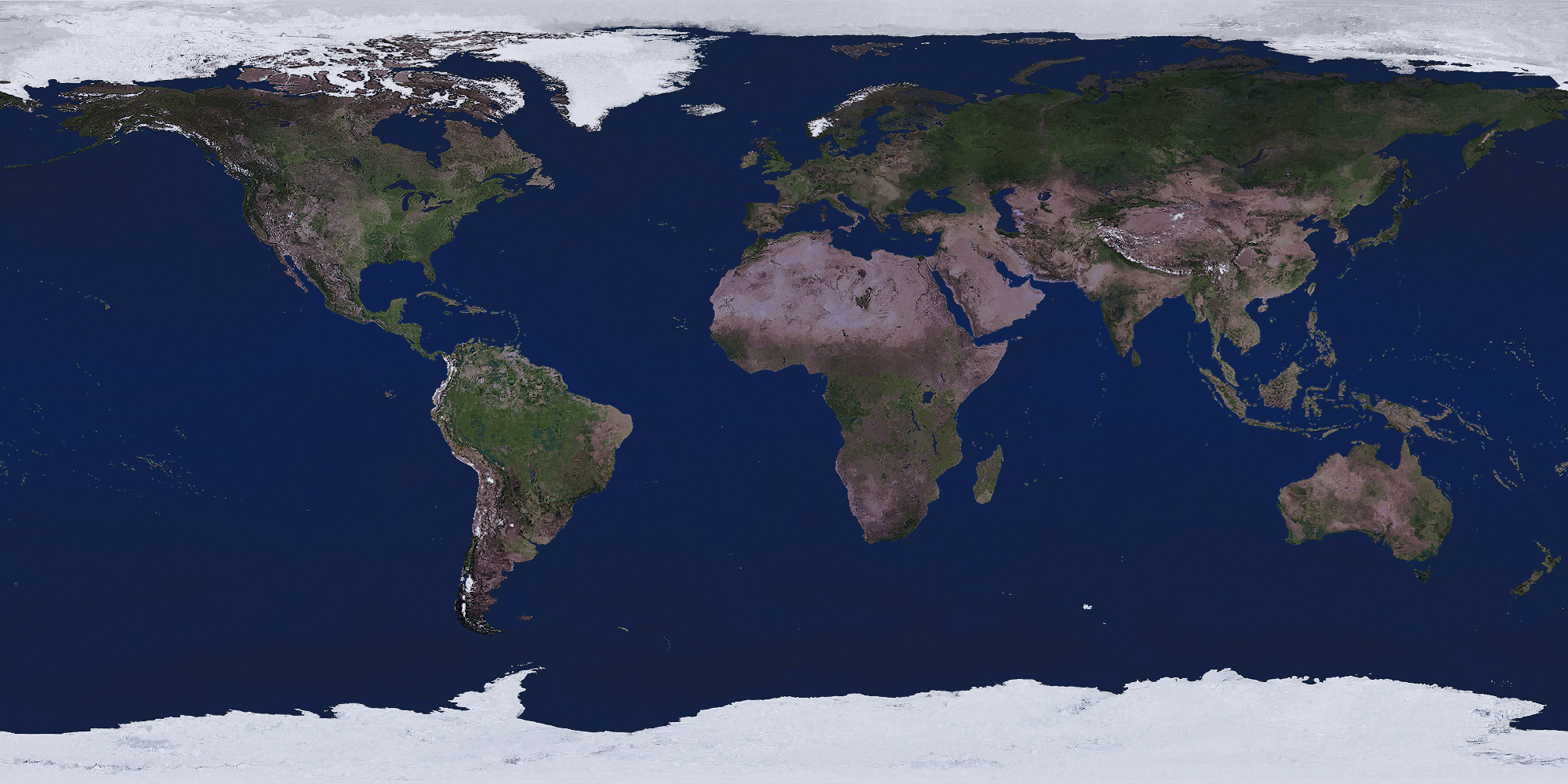
1b. Once you have found each country, test yourself by finding the location of each country again on an image of the Earth without border and country labels (Figure AIV-1).
2a. Using a political map of the USA, learn the locations of the US states and regions in the list below.
- Hawaii
- Alaska
- California
- Oregon
- Washington
- Wyoming
- Idaho
- Nevada
- Arizona
- Florida
- Baja California (Mexico)
- Hawaiian island chain
- Aleutian islands
2b. Once you have found each state, test yourself by finding the location of each state again on an image of the Earth without border and country labels (Figure AIV-1).
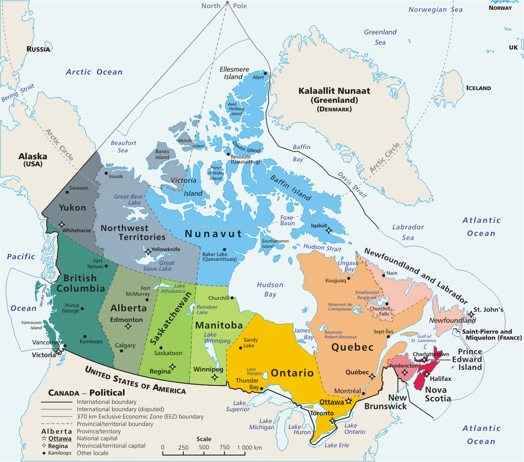
3a. Using a political map of Canada (Figure AIV-2) learn the locations of the 10 Canadian provinces (BC, Alberta, Saskatchewan, Manitoba, Ontario, Quebec, New Brunswick, Nova Scotia, Newfoundland and Labrador, and PEI) and 3 territories (Yukon Territory, Northwest Territories, Nunavut Territory).
3b. Once you have found each province, test yourself by finding the location of each province again on an image of the Earth without border and country labels (Figure AIV-1).
3c. Locate the following regions/places on a map of Canada. Use Google Maps or Google Earth to locate the places if you cannot find them on Figure AIV-2.
- Queen Charlotte Islands
- Vancouver Island
- The maritimes (the maritime provinces – Nova Scotia, Newfoundland, PEI, New Brunswick)
- The prairie provinces (Alberta, Saskatchewan, Manitoba)
- Canadian Arctic Islands
- Vancouver
- Edmonton
- Calgary
- Saskatoon
- Regina
- Winnipeg
- Flin Flon
- Thunder Bay
- Fort McMurray
- Sudbury
4. Using google maps, search for and learn the locations of the following oceans and water bodies:
- Atlantic Ocean
- Pacific Ocean
- Arctic Ocean
- Indian Ocean
- Antarctic Ocean
- Gulf of Mexico
- Mediterranean
- North Sea
- Hudson Bay
- Red Sea
- Mississippi River (USA)
- Fraser River (Canada)
- Saint Lawrence River (Canada)
- The Great Lakes
- The Nile River, Nile Delta (Egypt)
- The Amazon River (Brazil)
- Red Sea
- Gulf of Aden
- Gulf of California
5a. Using google maps, search for and learn the locations of the following mountain chains:
- The Himalayas
- The Andes
- The Rocky Mountains
- The Pyrenees
- The Ural Mountains
- Cascade Mountain Range
- The Appalachian Mountains
- The Teton Mountains
- Zagros Mountains
- The Alps
5b. In which country (or countries) is/are each mountain chain located?
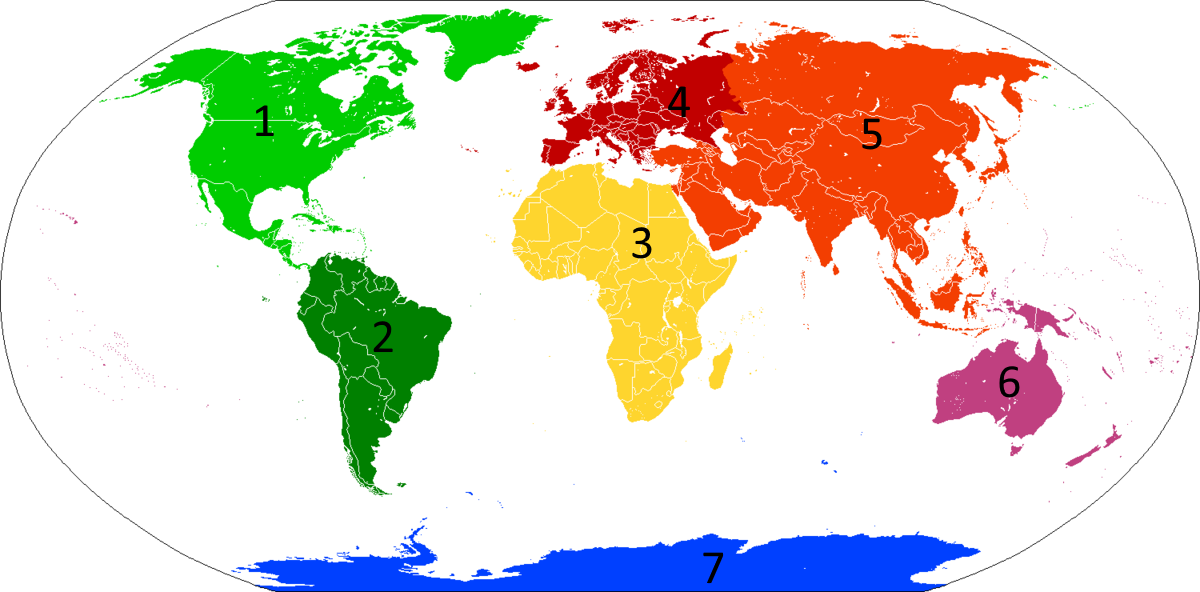
6. Figure AIV-3 shows the continents of the world. Name the continents that correspond to each numbered region on the figure.
