
1 Scale in Geography and Cartography
cartographic to problem scale
Scale is an essential geographic concept. Geographers study phenomena at various scales and often use the term scale to help define their research interests. Scale is integral to developing a scientific and policy-oriented understanding of our environment. Furthermore, scale can be a useful tool for examining the extent to which a single policy will have its intended impact on the environment. In terms of the scale of a particular environmental issue, an important question is whether the policy is intended to affect a local community or municipality or is it intended to impact a larger jurisdiction like a province, nation, or multinational region. Many policies surrounding environmental issues such as climate change and variability are designed to change the behaviour of local communities in ways that will positively impact a problem that occurs or functions at a much larger scale; in the case of global climate variability, the problem is global and will not be effectively addressed unless collective global action is taken. An example of government attempting to address a large scale environmental issue is the Act passed by the Saskatchewan government in December 2009 titled, An Act Respecting the Management and Reduction of Green House Gases and Adaptation to Climate Change. This Act addresses climate change issues that can be addressed by the province, while requiring that climate change and adaptation be addressed in concert with the federal government as well as partners around the world (other countries, multi-state organizations like the UN, G8, G20, and other influential bodies). It has been suggested that global climate variability is effectively mitigated through the harmonization and coordination of all levels of government (DeMarco, Routliffe, and Ladymore, 2004).
Similar, and tightly bound to Scale are Area of Study and Units of Analysis. The later, units of analysis, are the individual units used to study and explain phenomena that are occur in the are of study. Geographically, units of analysis are necessarily smaller than the area of study; there must be numerous units of analysis in order to establish a meaningful pattern in the area of study so the pattern can be used to explain, describe, or conclude something about the phenomena in question. In the USA we might use states (units of analysis) to explain a phenomena in the country (area of study). For instance, the election results of the Country can be displayed as the party earning the most votes by State and therefore we can map the pattern of results. In a city, we might use neighbourhoods, census tracts, or dissemination areas to explain social, political, or economic phenomena. So a pattern can be revealed, units of analysis need be smaller and more numerous than the area of study. At the other end of the continuum, there are fewer rules about the maximum number of units of analysis. Increasing the number of units increases the statistical power of a revealed pattern. Selecting a unit of analysis that is consistent with (or representative of) the phenomena in question (see Problem Scale below) is suggested, but not always feasible. For instance, Census data, is collected about many variables and uses common and consistent units of analysis (dissemination areas, tracts, districts, blocks, and block groups, etc.). Many times the availability of data will constrain the extent to which we can choose the unit of analysis for our area of study. Thoughtful consideration should be given to such decisions as units of analysis can impact the patterns mapped and conclusions made.
Scale is a concept as relevant to public policy as it is to natural and social science. Finding a good fit for environmental policy, and what a policy’s purpose is, requires understanding the intended environmental outcome (global climate variability, water quality, biodiversity, recycling, etc.) and the extent to which a policy is implemented in a political jurisdiction (province, country, etc.) can have the intended impact. Lay definitions of scale are also employed that are related and unrelated to the more strict definitions of the term employed in research-related endeavours. While each of the preceding applications of scale as a term and concept are not patently inappropriate, they do lead to confusion within, between, and among geographers, non-geography researchers, and the public. For example, when governments of different levels (such as Canada’s federal government, Saskatchewan’s provincial government, or local municipal governments) develop overlapping legislation, each legislative policy has the potential to contradict that from a different jurisdiction. Certainly this is a likely outcome in a province like Saskatchewan that has distinct urban/rural communities that have quite different needs and exhibit different day-to-day behaviours. While the classification of scale based on spatial dimensions, social institutions and practices, phenomena, and mathematics exist and have flourished within and beyond geography, there have been few attempts to categorize the nature of these different definitions and provide a systematic understanding of scale across disciplines. This chapter examines the diverse ways that scale is used within and beyond geography and academia with examples from environmental policy.
When the term scale is employed, it is contingent on the existence of a range of content-specific sub-scales. If something is said to be “scale-dependent” or “scale-specific” we can assume that there are spaces in which that phenomena flourish (in the case of scale specificity). While this is true, these types of statements (scale dependency or specificity) do not suggest anything about the special nature of the scale for the phenomenon or the process. For example, Grizzly bears in the Canadian and US Rocky Mountains require vast tracts of open wilderness for survival. Habitat for the individual bears must be available at a scale appropriate to provide a source of food and security (from other bears and humans). The survival of the Rocky Mountain bear population can be considered to be at least partially scale dependant. Taking a relatively common use of scale in geography, cartographic scale, as an example, one can see that the range of scales that become possible within this single definition of scale.
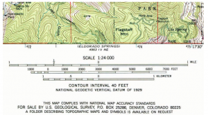
As suggested above, the term scale can be used in a variety of ways, only some of which are related to spatial extent. While cartographic scale considers spatial extent, its definition is essentially concerned with the direct relationship between what is shown on a map and the physical extent of that space in reality. Cartographic or representational scale is based on the mathematical relationship (ratio) between the extent of the representation and that which it represents. The representative fraction exists within the continuum of ratios (or fractions) of any two rational numbers. When comparing the relative size of two cartographic scales we compare the size of the number calculated by the ratio of the size on the map (numerator) and the size on Earth (denominator). For instance, a 1:100,000 cartographic map, would display a distance of 1km on Earth (1000 metres, 100,000 centimetres) with a distance of 1 cm on the map (1 cm on the map reprsents 100,000 cm in reality). Some might suggest that an extension to this broad definition be that the ratio must be less than one, resulting in a representation that is smaller than what it represents. It is for this reason that representational and cartographic are used above, to allow for representations, or models, that are larger than that which they represent. Therefore, this application of scale results in an infinite number of scales (for example, 1:24,000 or 1:50,000 for standard US and Canadian topographic sheets).
Cartographic scale is convenient for many reasons, not the least of which is that for any two scales we have an immediate understanding of the quantitative spatial relationship between them. As one changes cartographic scale, a direct relationship between the representation and the actual space is explicit and known; space and scale are dependent on one another. For a given cartographic scale, very little can be said about the phenomena being represented, in essence the square, or rectangle (or other shape), that is doing the representing can represent a space on the Earth’s surface, or any space, for that matter.
When cartographic scale increases (like from 1:1,000,000 to 1:50,000) the area on Earth that can be displayed decreases, while the detail of the geography being represented can increase (for the area displayed).
Problem scale refers to the relative size of the space covered by a process or phenomena; large scale problems cover relatively large spaces, and small scale problems cover relatively small spaces. For example, climate change and variability are large scale problems because their impact is global, while developing a curbside recycling program in Saskatoon, Saskatchewan, is a small scale problem because it is an issue which affects the city of Saskatoon alone. These differences are relative because there are no finite boundaries between a large, small, or any other space of a designated size. As introduced earlier, in 2010, provincial climate policy is identified as one of Saskatchewan’s most pressing environmental policy areas of the year. However, the specific implementation of a climate change action plan is multi-scaled and does not equitably administer resources. Subsets of the policy apply to homes, individuals, or families, while other climate-focused programs have already been criticized as being out of sync with actually dealing with climate change variability. By focusing on certain alternatives, a provincial policy dedicated to modifying individual behaviour (retrofitting and renovating homes) might benefit some groups more than others (urban vs. rural). On the other hand, recycling programs are considered substantially smaller scale problems that have both impacts and solutions that meet at a common scale. Reducing the amount of open land required for waste can reduce a community’s infrastructure costs. Furthermore, recycling has the additional benefit of allowing waste to re-enter the supply stream in the local economy.
Many geographers would suggest this use of the term scale (problem scale) could, and perhaps should, be replaced by the word size. As will be made evident below, problem scale is likely the more often used concept of scale than cartographic scale. It has been used to describe differences in spatial extent as they extend to functional relationships that exist in both physical reality and policy outcomes. Problem scale, not unlike cartographic scale, takes advantage of common terms for changes in scale; these include, but are not limited to, small, medium, large, etc. While problem scale is also based on a relative relationship between the sizes of the space in which problems exist, the nature of this size (physical extent)—scale relationship is quite different than that between varying cartographic scale and the referent space. Problem scale is based on a direct relationship (positive correlation) between scale and spatial extent (larger problem, larger space; smaller problem, smaller space). Furthermore, unlike cartographic scale, changes in problem scale, or comparisons between two scales, are not quantifiable. While a local problem, as defined by problem scale, is obviously a problem occurring in a smaller space than a regional or global problem, it is difficult to calculate a ratio between the two because discrete boundaries are likely unavailable (as they are on a map sheet). In addition, the range of problems that can be described is so broad that for a single environmental issue there might be instances where the problem impacts a relatively small space and other instances where the space is vast. Water quality and watershed health is an example. Contamination of a water supply can happen locally or at a large scale; for instance, if the Mackenzie River is contaminated, the impacts will be felt across much of Canada’s north and have the potential to cross international political boundaries; however, if a subsystem of a watershed is contaminated (such as Beaver Creek along the South Saskatchewan River), the impact will be felt over a much more limited and local area.
Functional scale refers to those situations where the general concept of problem scale (i.e., large scale refers to large spaces) can be used to describe a relationship between changing scale and function of some phenomena or process. Problem scale is relevant when comparing across types of phenomena or processes, functional scale should be applied in situations in which spatial extent is used to define a classification scheme for a process or related phenomena. In situations where a process or function varies as spatial extent (or scale) varies, and scale is used to define that variability, functional scale is the relevant concept for describing the spatial component of that relationship. While spatial extent may be the determining factor in the variability of some process or phenomena, the nature of the relationship with space is determined by the internal characteristics of the phenomena. It is for these relationships that the hierarchical nature of scale is most relevant. For a given phenomenon or process it is important to define its existence, or how it functions, across different scales, and whether an optimal scale (or range of scales) exists. For example, the hierarchical nature of political systems (municipalities within provinces, or provinces within countries) simply means that decisions and policies implemented at the top will in turn affect smaller and smaller units as that policy “trickles down.” For instance, Canada’s signing onto the Kyoto Accord results in specific federal policies regarding climate change that govern the development of provincial policies and their implementation at the local level. However, we cannot assume that a provincial policy in Canada will necessarily impact a smaller space than a federal decision elsewhere. These internally structured scaled relationships result in a subset of the functional scale that could be termed internal functional scale.
Psychologists, cognitive scientists, geographers, and many others have examined the cognitive dimensions of space and scale (Mandler 1983; Gärling and Golledge 1987; Montello 1993; Freundschuh and Egenhofer 1997; Egenhofer and Golledge 1998). Each of these classifications has subdivided space based on human interactions (physical, cognitive, and perceptual) with spaces of difference size. Relatively larger spaces require different mechanisms than smaller spaces. A good example would be the search for a hidden object. If that object is hidden on a desk, the individual performing the search would likely move objects around on the (cluttered) desk in order to reveal hidden objects. In a larger space, perhaps a university campus, one would be compelled to walk around the space in order to place him/herself in a position to see hidden objects that are obscured by other (likely immovable) objects such as buildings. So, a shared objective results in quite different behaviours in these two different sized spaces. We can extend this to political or policy environments; in Canada, provinces can only impact behaviours within their jurisdictions and with respect to topics covered by their mandate. Such relationships suggest that in a given political jurisdiction the government will focus only on their mandate; in reality, however, there are many instances of “overreaching” by governments (for instance, the long “states rights” in the United States).
The “size is equivalent to scale” definition is not limited to a cognitive classification of space, but can be extended to many other situations. Within the biological sciences, particularly those branches interested in the complex interactions among species, there are also a variety of classifications of space based on the physical extent (size) of space. Ecology, conservation biology, and environmental management are disciplines in which scale is a prevalent theme, and almost always refers to the physical size of the space and types of interactions that occur in such spaces. Poiani et al. (2000) classify difference sized spaces (scales) using physical extent as well as ecosystem organization. For each scale there are species, terrestrial, and aquatic targets, as well as some general expectations of what one might find at each scale. The smallest geographic scale is local (<2,000 acres), followed by intermediate (1,000–50,000 acres), coarse (20,000–1,000,000 acres), and regional (>1,000,000 acres) (Poiani, Richter et al. 2000). In addition, there are general references to the types of features that might be included in each spatial scale, including biotic and abiotic factors.
The “size is equivalent to scale” relationship works nicely for internal classification schemes, or when a common process or feature can be used to determine how size and phenomena interact. There are many situations in which the relationship between scale and the terms to which it is appended do not have easily described relationships with changes in spatial extent. Examples include the many environmental issues surrounding water and source water protection. Issues and policies surrounding water protection, as stated by organizations such as The Prairie Water Directive, can be trans-provincial and transnational in nature. This results in bodies like the Prairie Water Directive pressing governments to make policies that are appropriate not only for a specific province or municipality, but for multiple provinces and potentially multiple countries, as a lack of environmental policy in one area may, in fact, have substantial impacts on a neighbour (whether those neighbours are communities, provinces, or countries). These situations often arise when the term scale is used to differentiate between place-based differences in geographic phenomena. The spaces characterized by this type of scale generally do not have shared meaning, although geographers, and others, will often use scale to differentiate between different types of places, and the phenomena and processes unique to those places. For instance, certain problems that are endemic of built environments with high population densities are often described as occurring at the urban scale, or being urban scale issues. In order for this definition to exist (urban scale), non-urban scales must exist, but these are not necessarily tied to changes in spatial extent or spatial properties of any kind (location, distance, area, etc.). In individual situations the urban scale may extend over larger or smaller spaces than the rural scale. The nature of the difference between the two scales (urban and rural) is based on non-spatial properties, such as demographic character, organizational structure, culture, cultural and social landscape, transportation features, etc. These types of scales are often said to be socially constructed, and while they have important spatial characteristics, they are not defined by their spatial nature. An example of a socially constructed scale would be a distinctive community within a city that is made up of culturally defined groups, and not necessarily related to a specific boundary or physical geographic space within the citiy’s limits.
The use of the term external is based on the relative importance of space to the variations in scale and on the fact that for each scale employing this definition (rural, urban, homeless, education, etc.) the critical processes or phenomena has an important non-spatial foundation, and the basis of a definition of that phenomena (essential rural or urban phenomena) is uniquely important to it. What is critical, however, is that within any scale a hierarchy of component scales or entities can be identified and declared (Brenner 2001; Purcell 2003). The urban scale is made up of individuals, households, neighbourhoods, precincts, etc., and the rural scale is made up of individual, households, community groups, etc., that are unique to the respective rural or urban setting and may not necessarily be unique to the physical space or place but can be culturally, socially, and economically defined. Such definitions are critical when considering environmental policy, as the community in question must be part of the decision- and policy-making process. A “one size (scale) fits all” approach will not work.
