Chapter 8. Geological Structures
Exercises on Geological Structures Part 1: Strike, Dip, and Structural Cross-Sections
Adapted by Karla Panchuk, Joyce M. McBeth, & Lyndsay R. Hauber (2018) University of Saskatchewan from Deline B, Harris R & Tefend K. (2015) “Laboratory Manual for Introductory Geology”. First Edition. Chapter 12 “Crustal Deformation” by Randa Harris and Bradley Deline, CC BY-SA 4.0 View source. Last edited: 8 Jan 2020
In Part 1 of geological structures, students will learn how to interpret strike and dip information, prepare a geological cross-section from a plan-view geologic map, and measure the thicknesses of geologic units.
Name: _______________
NSID and student number: ____________
Date and lab section time: _____________
TAs’ names: _______________ _______________
Please hand in this lab to your TAs at the end of the lab period.
This lab will take the full amount of lab time to complete. This lab and the second geological structures lab will be on the lab final and students often struggle with this material. Read the lab and overview section online in advance so you can make best use of your time in lab.
8.E1 LAB EXERCISE – STRIKE & DIP
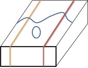
1. (1 pt) For the following block diagram, determine the correct map symbol that should appear in the blue oval. Note: the beige and red lines represent beds and the wavy blue line is a stream.
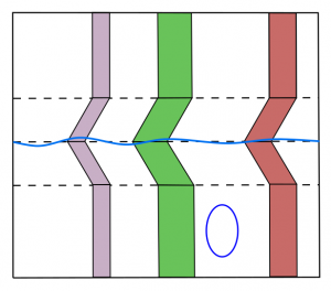
2. (1 pt) For the following map view diagram, determine the correct map symbol that should appear in the blue oval. Note: the purple, green, and red lines represent beds, the wavy blue line is a stream, and the dotted lines are elevation contours.
3. (1 pt) Using Google Earth or Google Maps, search for the following area in Pakistan: 27 50 35.00N 67 10 03.70E. If you are using Google Maps through your browser, make sure satellite data is turned on. Zoom out to an eye altitude of approximately 7.9 km (about 26,000 feet; the scalebar in Google Maps will be 500 m long at this height). Note: double check that the position of the north arrow is pointed to the top of your screen before you answer the question! The layers in these folded rocks can be seen from this altitude. What evidence do you see that indicates the direction the rocks are dipping? Hint: If you zoom in a little bit closer on the gully that runs through the strata near the position marker you can see an example of the rule of V’s in the darker-coloured strata.
4. (1 pt) Which direction are the beds dipping?
- Northeast (NE)
- Southeast (SE)
- Northwest (NW)
- Southwest (SW)
8-E2: EXERCISES – CROSS-SECTIONS
The three geological maps on the next few pages will give you practice with constructing geological cross-sections.
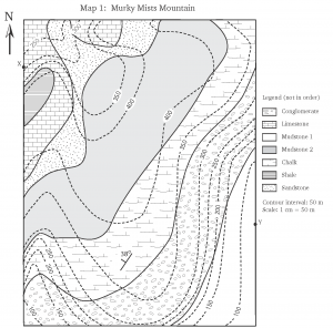
Map 1: Murky Mists Mountain
- (2 pts) Examine the map of the Murky Mists Mountain. Refer to the map legend. What kind of rocks are found in this map area: sedimentary, igneous, and/or metamorphic? How many units can you see?
- (2 pts) Note the strike and dip symbol on the map. Presume that the units all have identical strike and dip. Which direction are the units striking and dipping?
- (2 pts) Examine the contour lines on the map (dashed lines). Where are the highest points on the map? Where are the lowest points on the map?
- (2 pts) Note the scale of the map. What is the distance in metres between point X and point Y? If you walk from X to Y, in what direction are you walking?
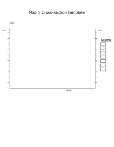
- (15 pts) Prepare a cross-section through the map from position X to Y (X-Y) using the cross-section template we have provided. Do not forget to indicate the X and Y positions on your cross-section. Also, add a scale bar and the ratio scale, legend, and a title. To remember to add these critical components of a cross-section, remember the acronym L.O.T.S. (legend, orientation, title, scale). Note: ensure your vertical scale and horizontal scale are the same, and order the units in your legend with the oldest at the bottom and the youngest at the top.
- (5 pts) Using the cross-section you have prepared and the distances between the upper and lower contacts for each unit, calculate the thickness of the limestone, sandstone, mudstone 2, chalk, and conglomerate units. Mark the location where you measured your thicknesses with a line on your cross-section. Note: the thickness is the shortest distance between the upper and lower contact of a bed: a line that runs perpendicular to both contacts.
- (1 pt) Why can’t you measure the thickness of the shale or mudstone 1 units?
- (3 pts) In point form, describe the geological history of the map area. Hint: start with the oldest event and describe events as they occurred up to the present day.
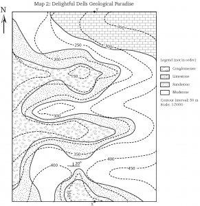
Map 2: Delightful Dells Geological Paradise
- (2 pts) What kind of rocks are found in this map area (sedimentary, igneous, and/or metamorphic)? How many units can you see?
- (15 pts) Draw a geological cross-section between the points X and Y indicated on Map 2. Note: you will have to prepare a cross-section from scratch for this exercise, but you can use the format from the Map 1 cross-section as a guide. If you are not sure where to start, use the questions from Map 1 to guide you through the process of exploring Map 2 and preparing your cross-section. Do not forget to incorporate the features described in the L.O.T.S. acronym. This is a more challenging cross-section – you will probably have to make several changes to get it right. Make sure you have an eraser with you!
- (2 pts) What are the thicknesses of the mudstone and sandstone layers? Indicate the locations where you performed these measurements on your cross-section.
- (1 pt) Why can’t you measure the thickness of the conglomerate or the limestone?
- (2 pts) In point form, describe the geological history of the map area.
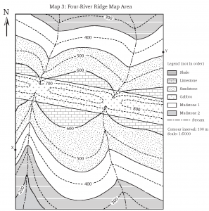
Map 3: Four-River Ridge
- (2 pts) What kind of rocks are found in this map area (sedimentary, igneous, and/or metamorphic)? How many units can you see?
- (1 pt) Carefully study the relationship between the contour lines and the contact between the limestone and sandstone. What does this tell you about the orientation of these beds?
- (1 pt) Examine the gabbro unit. What V pattern is formed by the four rivers that cut through this unit? What does this tell you about the orientation of this unit?
- (2 pts) What is the strike and dip of the sedimentary units in this map area?
strike = ____________ dip = _____________ - (2 pts) What is the strike and dip of the gabbro dyke?
strike = ____________ dip = _____________ - (15 pts) Draw a cross-section through the map area along the line between points X and Y. Hint: don’t forget to incorporate L.O.T.S.!
- (4 pts) In point form, describe the geological history of the map area.
Maps used in these lab exercises:
- Map 1: Murky Mists Mountain
- Map 1: Cross-section template
- Map 2: Delightful Dells Geological Paradise
- Map 3: Four-River Ridge