
Chapter 7. Topographic Maps
5 Extra Practice Question on Topographic Maps
Adapted by Joyce M. McBeth, Sean W. Lacey, & Tim C. Prokopiuk (2018) University of Saskatchewan from Deline B, Harris R, & Tefend K. (2015) “Laboratory Manual for Introductory Geology”. First Edition. Chapter 3 “Topographic Maps” by Karen Tefend and Bradley Deline, CC BY-SA 4.0. View Source.
7-E3 Extra Practice Exercises – Topographic Maps
For questions 1 to 4 refer to the Map 7-E11. The following topographic map shows an interesting geological feature called a drumlin, which is a pile of sediment left behind by a retreating glacier.
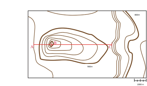
Source: Sean Lacey (2018) CC BY 4.0, after Brad Deline (2017) CC BY-SA 3.0 view source
1. What is the contour interval on Map 7-E11?
2. What is the regional relief on Map 7-E11?
3. Using the contour lines on Map 7-E11, which section along the red line through the centre of the map is steeper: A to B or B to C? Explain how you came to this conclusion.
4. Calculate the gradients from A to B and B to C on Map 7-E11? Show your work.
5. Drumlins can be used to determine the direction of glacier ice flow. The glacier moves in the direction from the steeper side to the shallower (less steep) side of the drumlin. Using your previous answers for Map 7-E11, what direction was the glacier traveling? Note: assume that the top of the map is north.
