
Digging Across Canada
10 Soils of the Prairie Provinces
Daniel J. Pennock
LEARNING OUTCOMES
Upon completion of this chapter, students will be able to:
- Describe the factors responsible for the distribution of soils in the Prairie Provinces
- Identify the diagnostic soil horizons associated with soil orders and great groups (according to the Canadian System of Soil Classification) of the Prairie Provinces
- Relate the major land uses of the region with the properties of the soils
INTRODUCTION
The soils of the three Prairie Provinces have experienced the greatest conversion to agricultural land uses of any region of Canada. In most of the southern portion of this region more than 80% of the land is agricultural (Prairie Farm Rehabilitation Administration, 2000). Throughout this region the specific type of agriculture is closely linked to the capability of the soil, and hence the pattern of agricultural land use is largely determined by the pattern of the soils themselves. Although we typically refer to Alberta, Saskatchewan and Manitoba as the Prairie Provinces, it is important recognize that the true prairies generally occupy only the southern portion of these provinces.
FACTORS CONTROLLING THE DISTRIBUTION OF SOILS IN THE PRAIRIE PROVINCES
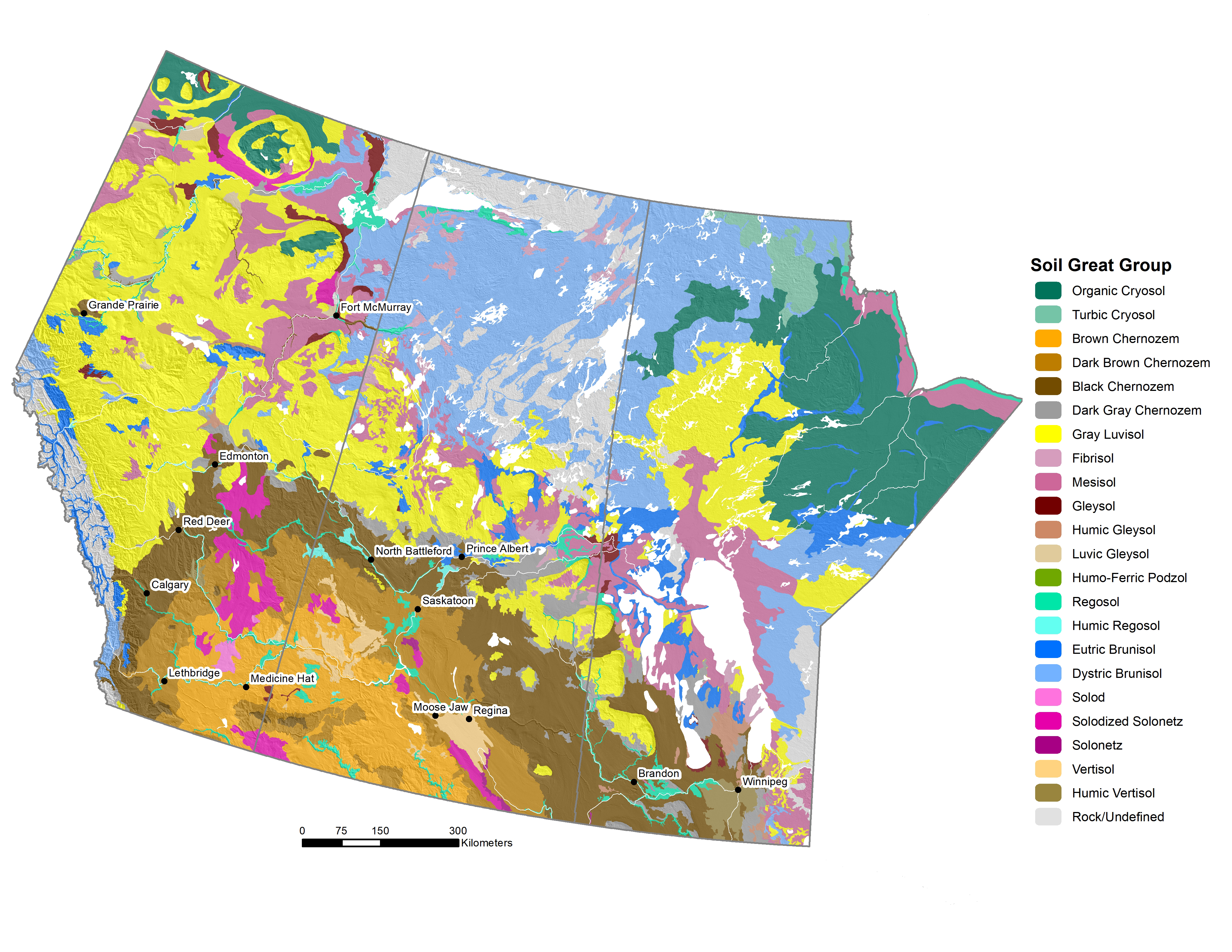
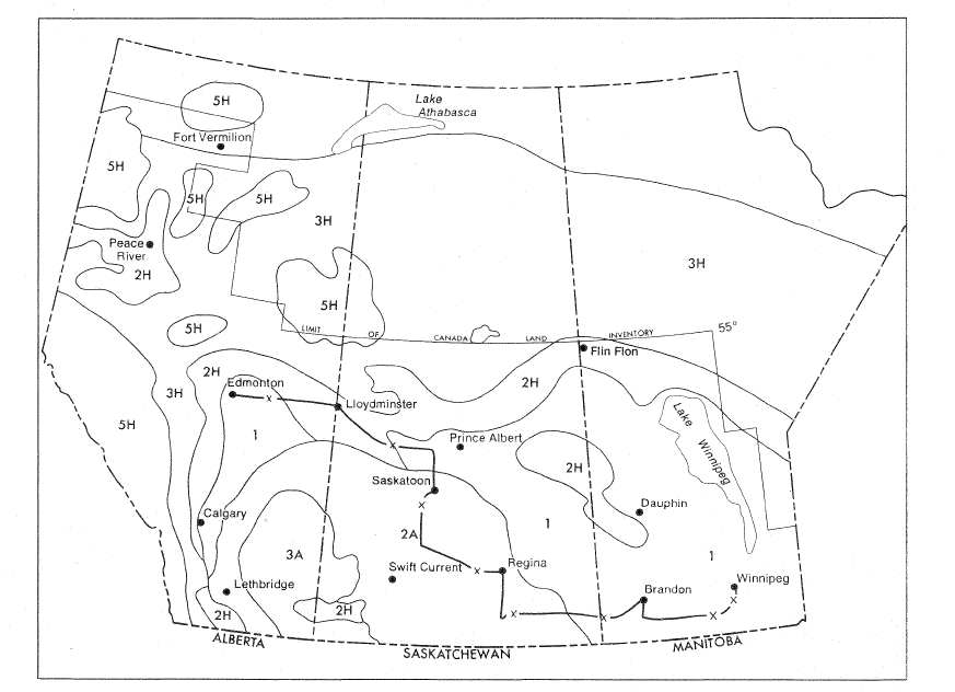
The regional pattern of soil distribution (Figure 10.1) is determined by the bedrock geology and the effect of the Western Cordillera on the regional climate. These two factors largely determine the patterns of soil and vegetation in the region.
The Prairie Provinces are underlain by approximately ⅓ igneous and metamorphic rocks of the Canadian Shield and ⅔ sedimentary rocks (Figure 10.2). The Canadian Shield underlies the eastern and north-eastern portion of the region, and sedimentary rocks the remainder. As discussed in Chapters 2 and 8, the glacial sediments that form the parent materials of soils closely reflect the nature of the bedrock that underlies them; igneous rocks yield acidic, sandy and gravelly parent materials and sedimentary rocks produce neutral, alkaline, loamy parent materials. The parent materials produced by sedimentary rocks are a mixture of gravel and sand, silt, and clay.
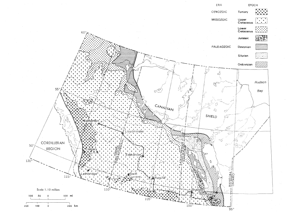
Research on tills in this region has shown that rock fragments greater than 1 mm in diameter are derived from the Precambrian rocks of the Canadian Shield to the NE of the sedimentary rock area, whereas the sand, silt, and clay fractions normally reflect nearby geological formations (St. Arnaud, 1976). The glacial tills also contain carbonates and soluble magnesium and sodium salts. The carbonate content of the tills is highest (>40% calcium carbonate equivalent) in the Interlake area of Manitoba where surface exposure of Paleozoic limestones occurs. The carbonate content of tills decreases across the region to about 6 to 10% in much of southern Alberta and 1 to 6% in central Alberta (St. Arnaud, 1976). The carbonate content rises to 10 to 16% in the Cordilleran regions of Alberta in the region of deposition of glacial sediments from the Cordillera itself.
The northern boundary of the continuous Chernozemic region is found north of Edmonton in Alberta and then trends to the south-east until it ends just north of Winnipeg (Figure 10.1). This NW-SE trending boundary reflects in part the influence of the Western Cordillera on the passage of moist, temperate air masses from coastal British Columbia into the western interior (discussed in Pennock et al., 2011). The air masses are deflected to the north by the high mountain ranges of southern Alberta and pass through the Cordillera via the lower elevations of the Peace River area of British Columbia and Alberta around Grand Prairie. The air masses then trend to the SE through the rest of the Prairie region. The more temperate climates of the Peace River region, which occur because of this movement of air masses, allow extensive agricultural development throughout the region and even the development of a pocket of Chernozemic soils around Grand Prairie (Figure 10.1).
MAJOR SOILS OF THE PRAIRIE PROVINCES
At the broadest scale, the sedimentary rock region has multiple zones of soils that radiate out from SW Saskatchewan and SE Alberta (Figure 10.1). The dominant soil order in the southern part of this region is the Chernozemic order, which formed in the grasslands that were found in this area prior to European settlement. Throughout most of the region, the Chernozemic soils are bounded by soils of the Luvisolic order, which are associated with the mixed deciduous-coniferous forest characteristic of the northern part of this region.
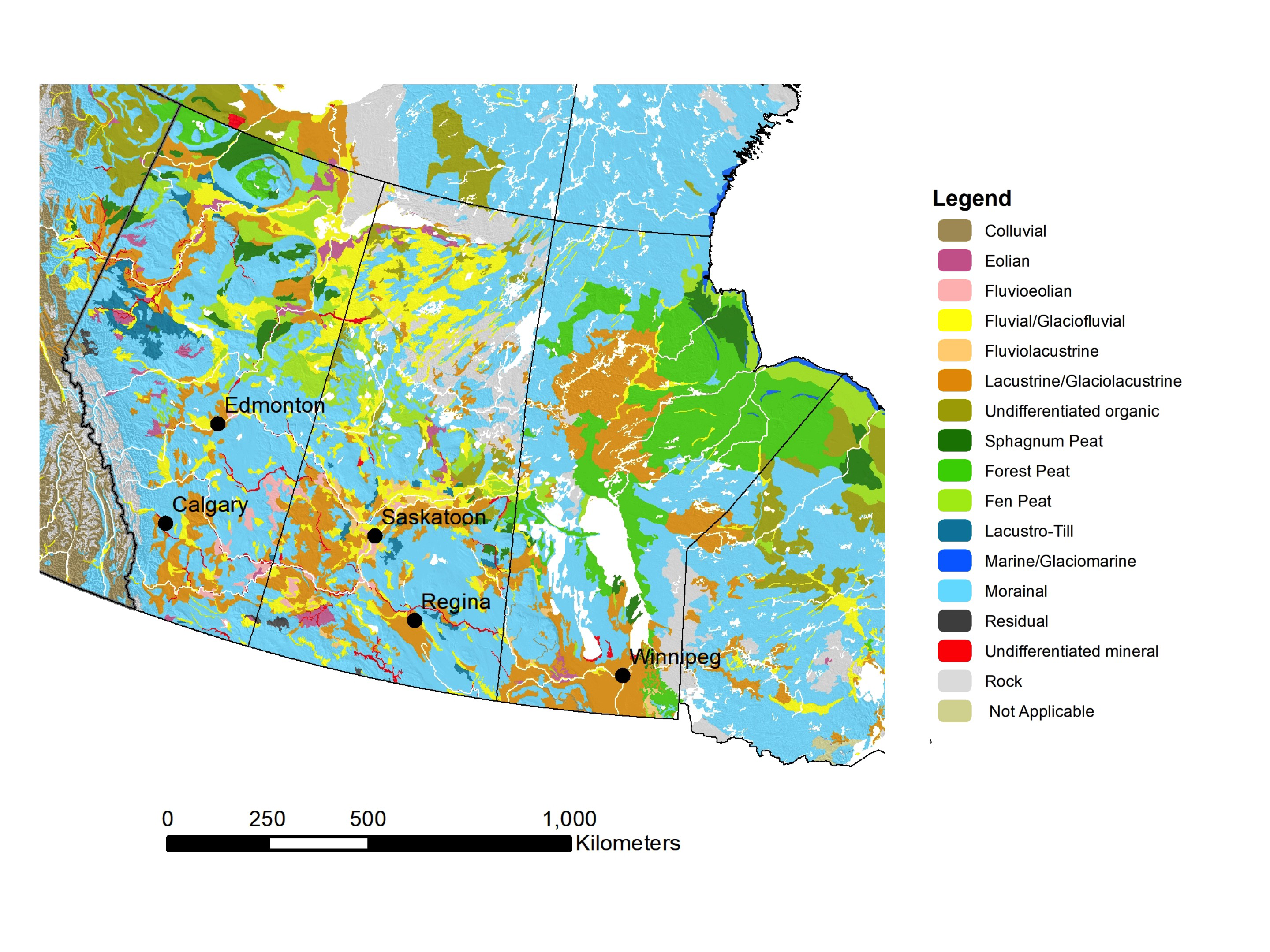
Brunisolic soils are the dominant soil order on the Canadian Shield and consists of acidic forest soils develop on the sand and gravelly parent materials characteristic of this area. In north-central Manitoba a large area of glacio-lacustrine silts and clays were deposited (Figure 10.3) and Luvisolic soils have formed in these parent materials.
Closer to Hudson Bay, the rebound of the land surface after glaciation has created a poorly drained region of near-level beach ridges and former shorelines with saturated soils. The cold temperatures and permanent water saturation has led to the development of thick layers of peat and formation of permanently frozen layers within the peats. These soils are classified as Organic Cryosols in the CSSC (Figure 10.1).
The complex pattern of soils in northern and north-eastern Alberta (Figure 10.1) departs from the overall zonation of soils. In this area there are several major uplands (such as the Caribou Mountains) that are elevated plateaus occupied by Gray Luvisols and Organic Cryosols. The uplands are separated by wide valleys occupied by the Athabasca, Hay and Peace Rivers. The relatively level valleys have a complex mixture of sandy Brunisolic, loamy Luvisolic and Fibrisol Organic soils. The extensive area of oil sand extraction near Fort McMurray devastates these soil landscapes, and reclamation of the landscapes (and remediation of the spoil from oil sands operations) is a major activity for soil scientists in this region.
Finally, the Cordilleran region at the Alberta-British Columbia border has a complex mixture of forested soils and exposed rock faces. The regional map (Figure 10.1) shows areas of exposed rock and both Dystric and Eutric Brunisolic soils, but areas of Gray Luvisolic soils also are found as well as Cryosolic alpine tundra soils at higher elevations.
GRASSLAND AND PARKLAND SOILS
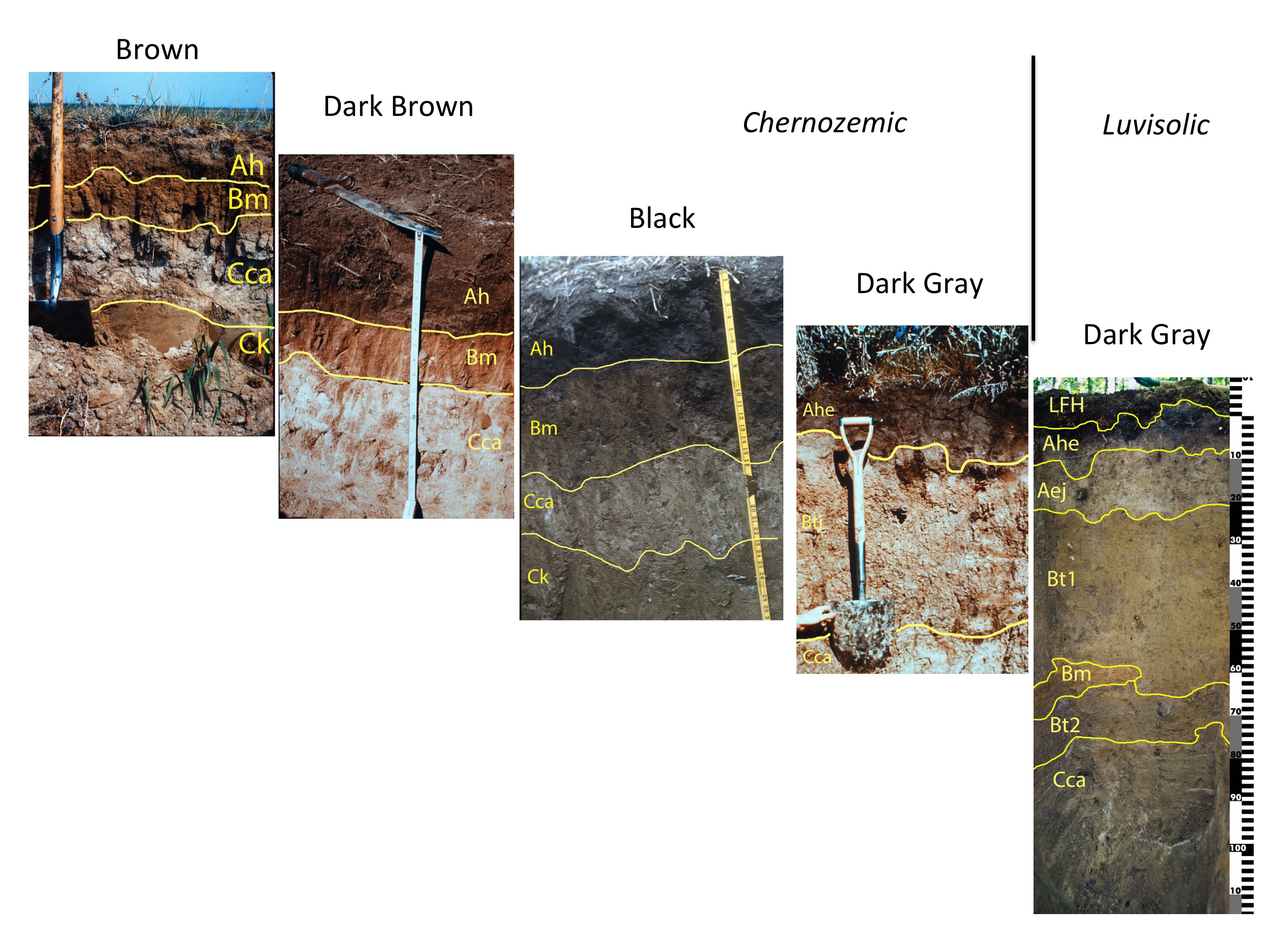
The zonal pattern of great groups of the Chernozemic order reflects the different types of grasslands that once occupied the area (and the regional climates responsible for the zonation of grasses) (Fuller, 2010; Pennock et al., 2011). These grasses were responsible for organic carbon inputs into the soil, and the colour of the diagnostic Ah horizons reflects differences in the amount of organic carbon additions from the various grass communities. The great groups of the Chernozemic order are based on the colour differences of the A horizons.
The major climate attribute that varies across the region is the mean annual water deficit (Pennock et al., 2011, Table 10.2). The driest portions of the region have annual water deficits of approximately 200 mm and the native grasses of this region were low grasses with limited above- and below-ground biomass. The lower organic carbon inputs lead to the development of soils of the Brown Chernozemic great group (Figure 10.4). The water deficit decreases west and north of this dry region, and greater organic carbon inputs lead to formation of Dark Brown Chernozemic soils and Black Chernozemic soils. The highest organic carbon levels occur in southern Manitoba where the annual water deficit is only approximately 70 mm.
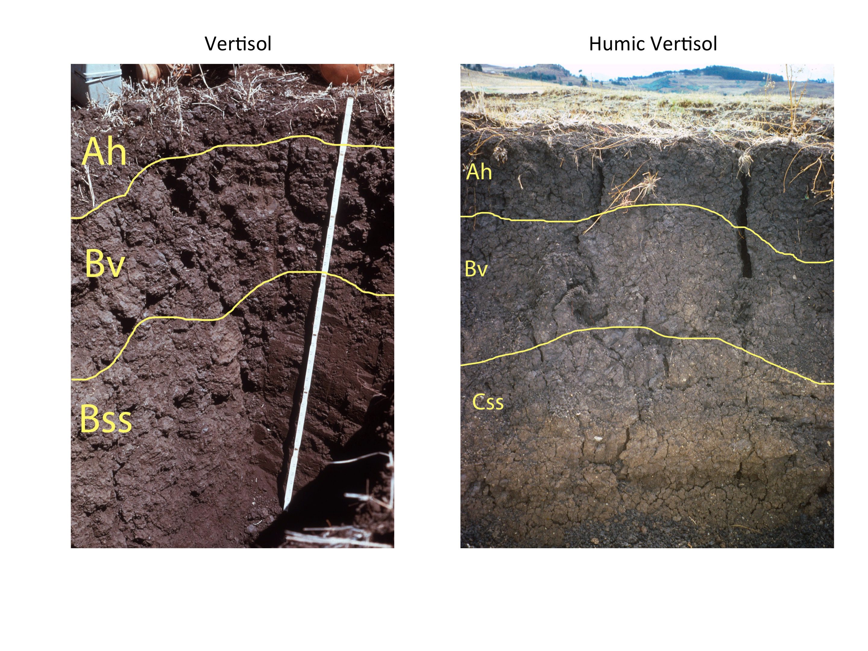
Within these broad soil zones there are many pockets of other soil classes in the former grassland areas (Figure 10.1). During melting of the ice sheets glacio-lacustrine silts and clays were deposited in vast glacial lakes throughout the region, with large areas of deposition in west-central Saskatchewan, southern Manitoba, and north-central Manitoba (Figure 10.3). In the former, grassland region the high-clay soils of the Vertisolic order form in these glacio-lacustrine deposits (Anderson, 2010a; Brierly et al., 2011). The great groups of the Vertisolic order (Figure 10.5) reflect the differences in organic carbon inputs discussed for the Chernozems above: Vertisols in southern Saskatchewan are classified into the Vertisol great group, whereas the higher organic inputs that occur in the region south of Winnipeg result in Humic Vertisols (Figure 10.1).
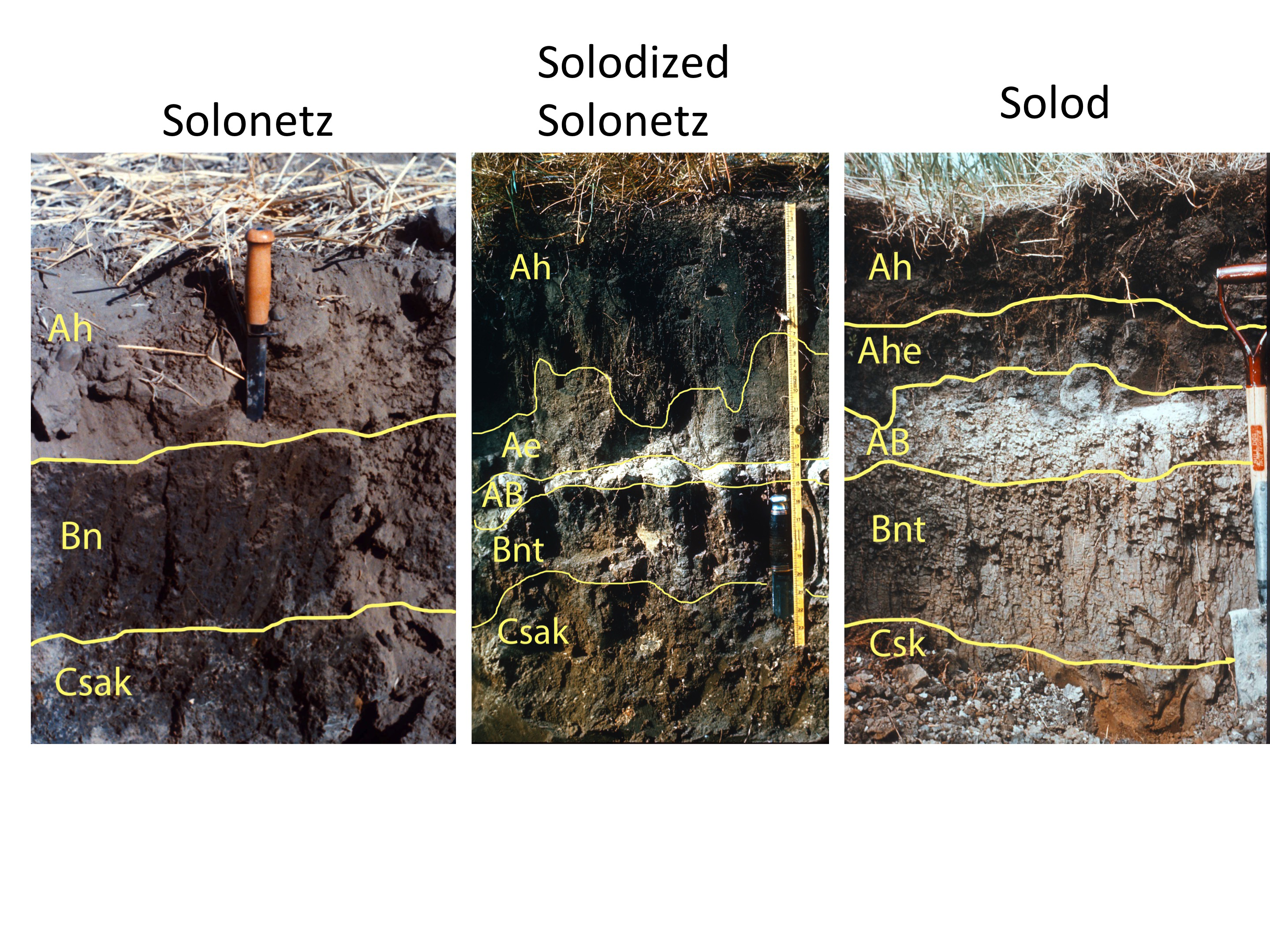
The distribution of Solonetzic soils is largely controlled by the presence of sodium-rich bedrock within a few meters of the soil surface rather than a particular type of glacial sediment (Anderson, 2010b; Miller and Brierley, 2011). In both Alberta and Saskatchewan, the marine shales of the Cretaceous-aged Bearpaw formation are the main bedrock type associated with Solonetzic soils. Movement of soil water and groundwater circulates sodium through the soil profile, which can lead to vertical movement of clay from the surficial Ah horizon soil to the B horizon and formation of a bleached, eluvial Ae horizon overlying the B horizon. The B overlies a saline and carbonate-rich C horizon (Csk).
The great groups of the Solonetzic order reflect the degree of development of the Ae horizon and the AB horizon, which forms through weathering of the upper B horizon. In the Alkaline Solonetz great group the Ae is very thin or absent, and the B horizon is high in sodium (Bn) but often without higher clay levels than the Ah (Figure 10.6). The Solodized Solonetz great group has an Ae greater or equal to 2 cm thick and an intact Bnt or Bn horizon with well-developed columnar structure. In the Solod great group the top of the Bnt has disintegrated through weathering and this weathered layer forms a transitional AB horizon between the Ae and the Bnt horizons. The Solodized Solonetz great group is the most common in the landscape (Figure 10.1).
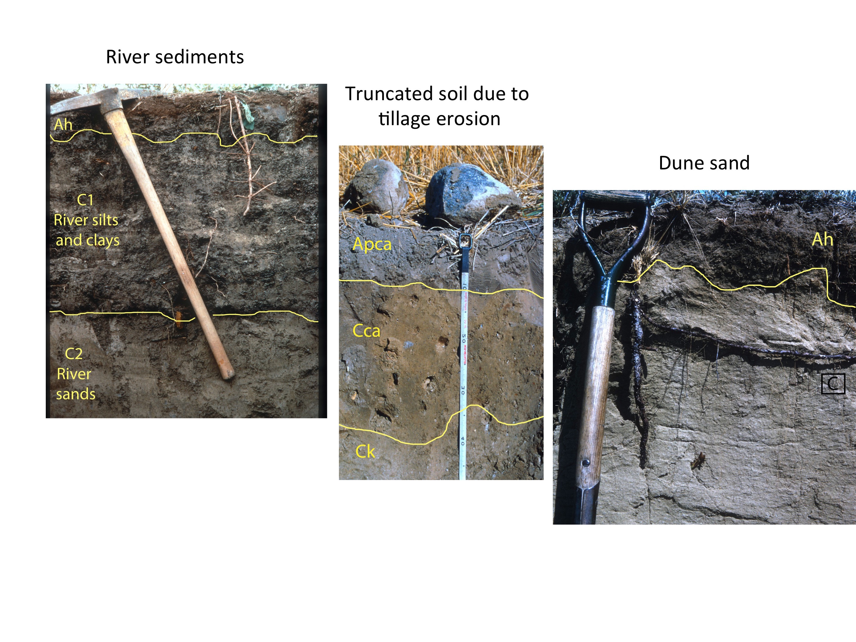
Small areas dominated by Regosolic soils (VandenBygaart, 2011) are also found throughout the region. Regosolic soils are associated with unstable land surfaces (such as river floodplain or sand dunes) where soil development is limited to development of an Ah horizon either directly overlying the C horizon or with a thin (<5 cm) Bm between the A and C horizons (Figure 10.7). The Regosol-dominated areas in the Prairie Provinces are associated with sandy fluvial or glaciofluvial deposits along river valleys or areas of active or recently stabilized sand dunes such as the Great Sand Hills of Saskatchewan. As well, the knolls in many cultivated landscapes in the Prairie Provinces have experienced considerable soil loss due to tillage erosion, and thin Ap (p for ploughed) horizons directly overlay Cca horizons on these hill crests.
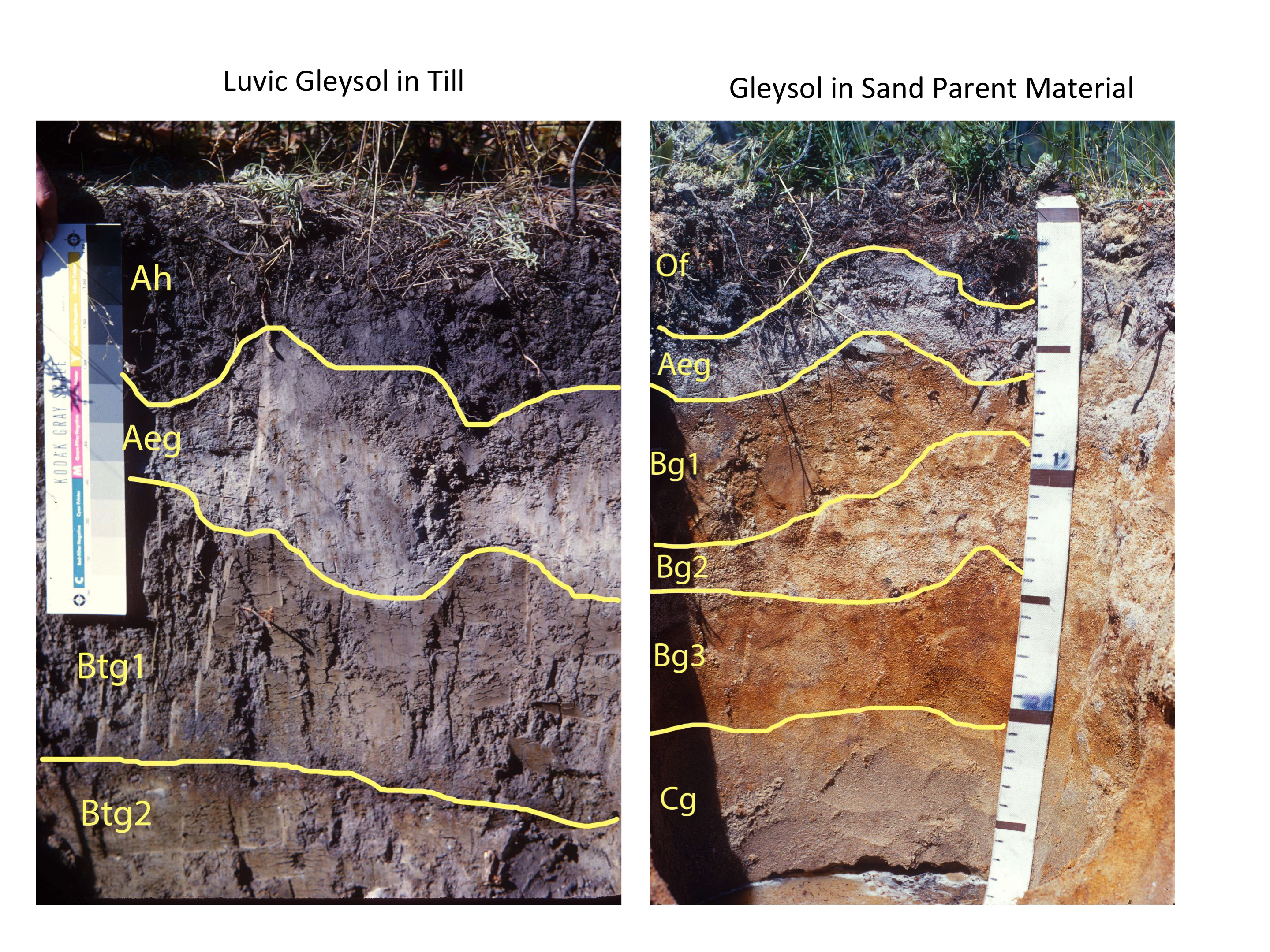
Many of the glacial landforms in the area are associated with melting in-place of stagnant ice masses, and the resulting land surface is a very complex assemblage of small knolls and depressions. This land surface is labelled as hummocky or knob and kettle on soil maps. Wetlands on these surfaces are often occupied by Gleysolic soils, whose Bg and Cg horizons have dull gray colours and, in some cases, patches of reddish oxidized iron within the dominantly gray material (Figure 10.8) (Bedard-Haughn, 2010, 2011). Texture-contrast horizons are also common in these soils, with a Btg horizons underlying a mottled Aeg horizon. Soils with a Btg horizon are classified into the Luvic Gleysol great group.
A final soil class that is largely unmapped are saline soils. As discussed in Chapter 8, the Canadian System of Soil Classification (CSSC) does a poor job of identifying saline soils. This is in part due to the very dynamic nature of soil salinity, which fluctuates considerably due changes to soil water and groundwater flow patterns. Salinity can only be recognized in profile descriptions through the use of the suffixes s and sa in horizon labels (e.g., Csa, Cs, Bsa, Ahsa, etc.). Agriculture and Agri-Food Canada has mapped soil salinization risk for several decades as part of its Agri-Environmental Indicators program and the main areas that are vulnerable to salinization (i.e., areas mapped as moderate, high, and very high risk) are widespread throughout the Prairie region. The largest areas are the region stretching NE from Calgary to almost Saskatoon, SW Alberta, in SE Saskatchewan near Estevan, and in areas of Manitoba south of Brandon and of Winnipeg. The AAFC maps show that the risk of salinization has decreased since the 1980s due to adoption of no-till cultivation practices and the near-elimination of tillage summer fallow throughout this region.
FOREST AND WETLAND SOILS
At the northern boundary of the Chernozemic soils the grasslands become increasingly interspersed with clumps of trees and shrubs and ultimately the forest forms an almost continuous cover over the soil. The transitional grassland-forest zone is referred to as the Parkland zone, and the continuous forest cover as the Mixedwood forest, reflecting the forest cover of deciduous and coniferous species.
In the Parkland, the inputs of organic carbon from grasses decrease and leaf litter from trees builds up on the soil surface as a LFH layer. The colour of the Ah horizon grows lighter, and bleaching of the horizon also begins to occur, forming a surface A horizon with both humus inputs (given an ‘h’ suffix) and bleaching (an ‘e’ suffix) – the Ahe horizon. These soils are classified into the Dark Gray Chernozemic great group.
North of the forest-grassland transition zone, organic inputs form a discrete layer laying on top of the mineral soil (the LFH layer) and the soils have a well-developed bleached layer (Ae horizon) overlying a B horizon with higher clay levels (Bt horizon). The Bt horizon is underlain by a C horizon with secondary (Cca) or primary (Ck) carbonates. These soils are classified into the Gray Luvisolic great group (Figure 10.9), which dominates the forested landscapes underlain by neutral-alkaline tills (Pettapiece et al., 2010; Lavkulich and Arocena, 2011). Gray Luvisols also occur in the large area of glacio-lacustrine parent materials in north-central Manitoba.

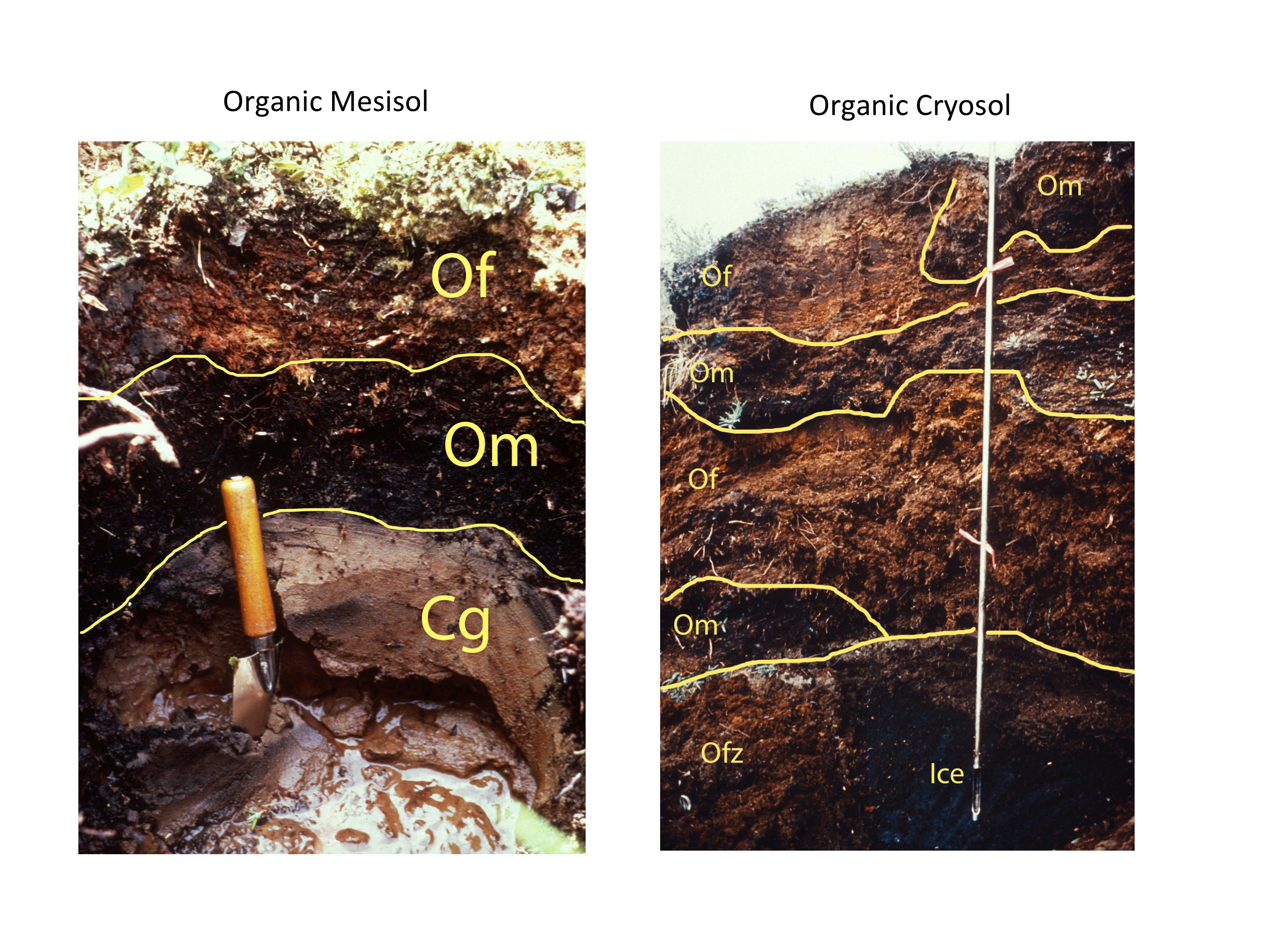
At the boundary between the sedimentary rocks of the Interior Plains and the Canadian Shield a complex assemblage of forest and wetland soils occurs (Figure 10.1). The forested soils form in parent materials that include sandy sediments from the Canadian Shield and pulverized sedimentary rocks, which raises the pH of the parent materials above 5.5. These soils are classified into the Eutric Brunisol great group (Figure 10.9) (Smith et al., 2011). In low lying areas, water collects and forms large fens and bogs. In these wetlands peat builds up due to the permanent water saturation and soils of the Mesisol great group of the Organic order occur (Bedard-Haughn, 2010). These soils have intermediate levels of decomposition of organic materials (Figure 10.10).
The dominant soil of the Canadian Shield itself are Dystric Brunisols (Figure 10.9) that develop in the acidic (pH < 5.5) sand and gravel parent materials characteristic of this region. Like the Eutric Brunisols, the Dystric Brunisols soils are very sandy soils and soil formation is limited to reddening of the B horizon and, in some cases, formation of a bleached Ae horizon. In moister forested regions of Canada, these conditions lead to formation of soils of the Podzolic order (Sanborn et al., 2011). There are also significant areas where exposed rock is the dominant surface with only scattered pockets of soils interspersed in the landscape (Figure 10.1).
Finally, the near-level landscapes of the Hudson Plains ecozone are mainly occupied by organic soils that have a layer of permafrost (i.e., permanently frozen soil) within the soil profile. These soils have thick organic layers but, because of the permafrost, are classified into the Cryosolic order (Figure 10.10) (Tarnocai and Bockheim, 2010).
SOILS AND LAND USE
Soil properties have a major impact on agricultural capability throughout the Prairie Provinces. The agricultural capability of soils throughout southern Canada was evaluated by the Canada Land Inventory (CLI) (see Chapter 8). The criteria used in the CLI system were based on soil and climate and remain generally applicable although cropping systems used in the region have changed greatly since the period of the CLI inventory (roughly 1965-1975). At that time the dominant crop was spring wheat and summerfallow (i.e., a year of fallow with tillage of the soil to suppress weed growth following a year of wheat) was the dominant tillage practice. Currently, a much wider range of crops (e.g., canola, pulse crops, flax) is grown, and the great majority of producers practice continuous cultivation with high amounts of crop residue left on the soil surface (i.e., conservation tillage or no-till).
In the CLI rankings, classes 1 through 4 are considered to be capable of sustained use for cultivated field crops. In class 1 land, there are no significant constraints to crop growth, whereas in class 3 and 4 areas the range of crops is restricted and special management measures are needed to conserve the soil. Classes 5 and 6 are only suitable for forage production and are most commonly used for grazing of livestock.
The major soil property that determines agricultural capability in the CLI system is soil texture due primarily to its effect on water availability. Secondary properties of relevance are unfavorable soil structure associated with Solonetzic soils and the presence of salinity in the soil profile. Soils that have experienced erosion of the organic-rich A horizons through time are also downgraded – organic matter has many beneficial properties including a high water-holding capacity and high nutrient-supplying power.
All agricultural regions of the Prairie Provinces experience a water deficit (as discussed above) and hence the ability of the soil to hold water during dry periods is critical. This property is termed the available water capacity (see Chapter 4). Generally, fine-textured soils (clay, heavy clay, silty clay, clay loam) retain the highest amounts of water even in drought conditions and have high available water capacity. Medium-textured soils (silty clay loam, sandy clay loam, loam, silt loam, fine and very fine sandy loam) have lower ability to hold water during droughts but have slightly higher available water capacity. Medium-coarse sandy loam, loamy sand, and sand soils have both very low ability to hold water during droughts and low available water holding capacities and hence are the lowest rated for agriculture.
The second major factor that determines the CLI class is the climate. In the Prairie Provinces, both moisture and heat can be limiting. Agriculture and Agri-Food Canada developed agro-climatic regions throughout Canada based on three climate factors: Mean annual precipitation, average number of frost-free days, and degree days above 5.5°C (Table 10.1 and Figure 10.11). The latter is a cumulative measure of the period when the temperature is high enough for significant plant growth. The class limits will have shifted somewhat due to climate change but the general pattern would be unchanged.
Soil texture is directly inherited from the parent materials in the Prairie Provinces; hence, a clear link between agricultural capability and the soil classes described above. At the driest end of the spectrum are the Regosolic soils formed in sandy glacio-fluvial sediments or sand dune areas, which typically have CLI classes of 5 or 6. At the other end of the spectrum are Vertisol soils, which inherently have clay or heavy clay textures and typically have CLI class 1 or 2 ratings throughout the main agricultural region.
The capability ratings for Chernozemic soils depends primarily on texture and on climate zone. The general pattern is clear from Figure 10.12: fine-textured soils are the best agricultural soils in each climate region and coarse textured soils the worst. The range is greatest for medium-textured soils developed on glacial till, which are the most common in the region.
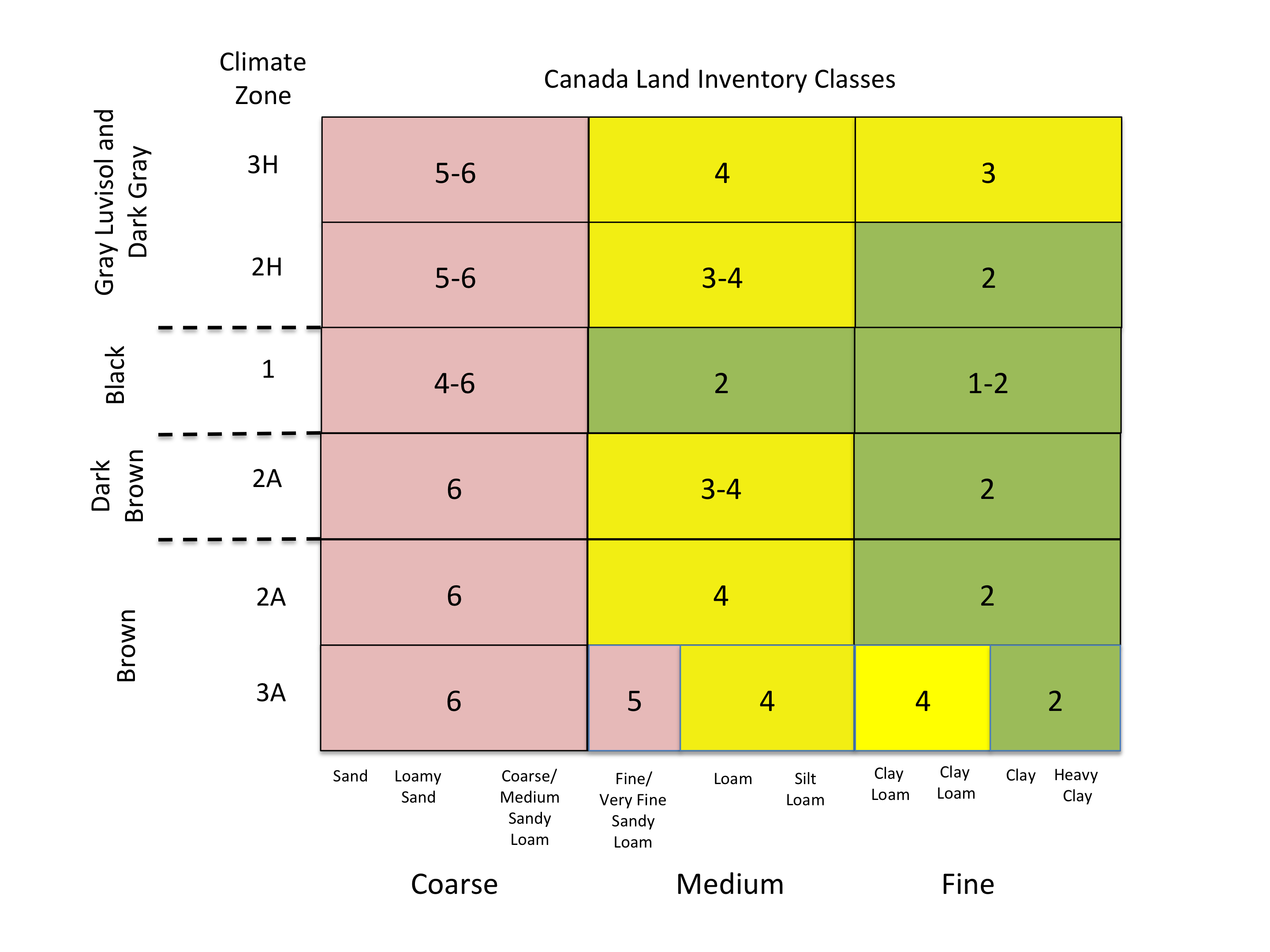
Gray Luvisolic soils have a number of limitations for annual crop production (Pettapiece et al., 2010). The Gray Luvisols occur in zones 2H and 3H (Figure 10.11) where lack of heat and frequent frosts limit growth. The Gray Luvisols lack an Ah horizon and typically have silty textured surface mineral horizons; both factors contribute to problems with seedbed preparation and crop growth generally. Compared to Chernozemic and Vertisols soils they are also deficient in nitrogen, phosphorus, and sulphur. The Gray Luvisols and related soils in the Aspen Parkland region are widely used for forage crop production and grazing – about two-thirds of western Canada’s cattle and more than 80% of the forage crops are produced in this region (Thorpe and Anderson, 2010).
Secondary soil properties that strongly affect agricultural capability are factors such as the presence of high sodium soils or salinity, both of which are generally associated with class 5 or 6 soils. The Bn or Bnt horizon associated with the Solonetzic soils are difficult for plant roots to penetrate and hence only the horizons above these horizons can be fully exploited by roots for nutrients and water. As well, the Ah and Ae horizons above the dense B horizons have often experienced erosion, and the variable depth of surface soil over the B horizon often gives crops on Solonetzic surfaces a wavy appearance due to lower growth on thin soils and higher growth on thicker soils. Salinity has a severe effect on crop growth and on highly saline soils growth of any plant except saline-tolerant species is impossible.
An important landscape factor that affects the rating of medium-textured soils is topography – generally the rougher the topography, the lower the rating. Many medium-textured glacial till landscapes have many knolls and wetlands associated with them, and these cause difficulties in farm operations and uneven plant growth. Rough topography generally causes a given area to drop by at least one class in the CLI rating.
Tableau 10.1: Régions agro-climatiques. (Adapté de Michalyna et al. 1978).
| Sous-régions climatiques | Précipitations annuelles moyennes (cm) | Durée moyenne de la période sans gel (jours) | Degrés-jours au-dessus de 5,5oC | Commentaires généraux |
|---|---|---|---|---|
| 1 | 40-45 | >90 | 1225-1670 | Le climat convient à la croissance de toutes les cultures de terrains secs typiques de la région des Prairies |
| 2A | 30-40 | >90 | 1330-1670 | Les précipitations limitent la croissance environ 50% des années |
| 3A | 27-35 | 90-120 | 1330-1670 | Les précipitations sont un facteur limitant important de la croissance des cultures |
| 2H | 40-50 | 75-90 | 1060-1225 | Le niveau de précipitation est adéquat mais des dommages liés au gel sont observés environ 30% des années |
| 3H | 27-35 | <75 | 1000-1112 | Le niveau de précipitation est adéquat mais d’importants dommages liés au gel sont observés |
| 5H | 27-35 | <60 | <950 | La période sans gel est trop courte pour la production de cultures annuelles |
Soil properties also play an important role in determining land capability for forest harvest operations. Forest harvest has increased in Alberta since early 2000s (from 82 thousand hectares (t ha-1) in 2005 to 92 t ha-1 in 2016). However, it has declined in Saskatchewan (42 t ha-1 in 2005 to 22 t ha-1 in 2016) and Manitoba (14 t ha-1 in 2005 to 8 t ha-1 in 2016) (all statistics from Natural Resources Canada). In total, this represents about 13% (2005) to 15% (2016) of total forest area harvested in Canada.
The Canada Land Inventory also rated soils for forest capability in the portion of the forest where commercial forestry existed. The highest class of land in the Prairie Provinces was only class 3 due to climate constraints for tree growth throughout the region. Generally, forests on Gray Luvisol soils are rated as class 4 (Alberta and Manitoba) or Class 5 (Saskatchewan) with small areas rated one class higher in all provinces. Forests on both Eutric and Dystric Brunisolic soils are generally rated as class 6 due to significant growth constraints. Detailed ecosite guides have been prepared for each province (see Suggestions for Further Reading) that rate soils on soil texture and soil drainage – generally well-drained, fine- and medium-textured soils are the most highly rated in the forest landscape.
Wetland soils in the Prairie Provinces are key contributors to two transnational and global issues: the protection of waterfowl in North America and the removal of carbon from the atmosphere by increasing soil organic carbon levels (carbon sequestration). In the former grassland areas of the Prairies, the complex hummocky land surfaces have countless wetlands that are occupied by Gleysolic soils or, in some cases, saline soils. These wetlands are the seasonal home for vast numbers of migratory waterfowl, and protection of Prairie wetlands is essential for preservation of waterfowl habitat. The North American Waterfowl Management Plan (NAWMP) is a major agreement among Mexico, the USA and Canada and protection of Prairie wetlands is a key aspect of this transnational plan.
Gleysolic wetlands and especially Organic soils are repositories for large amounts of carbon. Drainage of these wetlands for agriculture causes mineralization of this carbon and its release (as carbon dioxide) to the atmosphere. The restoration of wetlands and of the wetland vegetation that surrounds them has the potential to draw carbon from the atmosphere and hence lessen the growth in carbon levels caused by human activity. The 2019 report by the Intergovernmental Panel on Climate Change on climate change and land has highlighted the role that carbon sequestration by soils could play in greenhouse gas mitigation (Section 4.9.4 IPCC, 2019).
Finally, soils of all types have been extensively affected by resource extraction activities throughout western Canada. In Alberta alone, there are 422,000 km of oil and gas pipelines, 343,000 well sites (176,000 active wells, 90,000 inactive wells, and 77,000 abandoned wells) and 895 km2 have been disturbed by surface mining for oil sand production (as of 2013); oil sand tailing ponds and associated structures totaled 220 km2. (Sources: Agdex 878-4; Alberta Energy–Oil & Gas Liabilities Management; and Alberta Energy–Oil Sands, Coal and Mineral Operations). In all cases, legislation requires that the sites be reclaimed by replacing soil and re-establishing vegetation on the disturbed site so it can support activities similar to those it could have supported before it was disturbed. In situations where contamination has occurred the soils must be remediated (or cleaned up) to meet specific soil and groundwater standards. All of these steps require knowledge of soil properties and soil distribution, ensuring a continuing role for soil scientists form decades to come.
SOIL SURVEYS, LAND INVENTORY MAPS & FIELD GUIDES
Soil surveys in the Prairie Provinces can be queried on-line at the following sites:
Saskatchewan: sksis https://sksis.usask.ca/#/map
Alberta: AGRASID https://soil.agric.gov.ab.ca/agrasidviewer/
Manitoba: https://soils.gis4ag.com/manitoba-soil-series-interactive-online-map/
Soil information (surveys, CLI maps, historic publications, Canadian System of Soil Classification) is available on-line through the Canadian Soil Information Service (CanSIS) of Agriculture and Agri-Food Canada. An index to CANSIS can be found at:
http://sis.agr.gc.ca/cansis/nsdb/index.html
Provincial-scale Canada Land Inventory maps are available at:
http://sis.agr.gc.ca/cansis/publications/maps/cli/1m/agr/index.html
Field Guides for Forest Ecosite Classification
Saskatchewan https://publications.saskatchewan.ca/#/products/31663
Manitoba https://cfs.nrcan.gc.ca/publications?id=12179
Alberta https://cfs.nrcan.gc.ca/publications?id=25327
STUDY QUESTIONS
- Explain why the carbonate content of Prairie soils generally decreases from a high in central Manitoba to a low in central Alberta.
- Why do Chernozemic soils occur as far north as Grand Prairie in Alberta (see Chapter 8, Figure 8.1)?
- Looking at Figure 10.3 – on what parent materials south of the Canadian Shield would you expect to find soils of the Vertisolic order?
- Based on the material presented in Chapter 10, rank the following four soils in terms of their ability to support crop growth from highest to lowest: Black Chernozem, Gray Luvisol, Humic Vertisol and Solodized Solonetz. Briefly explain your ranking.
- What are the four main soil great groups found on the Canadian Shield in the Prairie Provinces (see Figure 10.1)? Which of the four great groups is “out of place” on the Shield and why is it found there?
- What secondary soil properties reduce the CLI class for agriculture soils to class 5 or 6?
- Wetlands in the agricultural zone are often drained for agricultural purposes. What soil order is most common in these wetlands and what are two important ecosystem services that they provide?
REFERENCES
Anderson, D.W. 2010a. Vertisolic soils of the Prairie Region. Prairie Soils and Crops Journal 3: 29-36. Available at: https://prairiesoilsandcrops.ca/volume3.php
Anderson, D. 2010b. Solonetzic soils of the Prairie region. 2010. Prairie Soils and Crops Journal 3: 65-72. Available at: https://prairiesoilsandcrops.ca/volume3.php
Anderson, D.W. and Cerkowniak, D. 2010. Soil formation in the Canadian Prairie region. Prairie Soils and Crops Journal 3: 57-64. Available at: https://prairiesoilsandcrops.ca/volume3.php
Bedard-Haughn, A. 2010. Prairie wetland soils; Gleysolic and Organic. Prairie Soils and Crops Journal 3: 9-15. Available at: https://prairiesoilsandcrops.ca/volume3.php.
Bedard-Haughn, A. 2011. Gleysolic soils of Canada: Genesis, distribution and classification. Can. J. Soil Sci. 91: 763-779.
Brierly, J.A., Stonehouse, H.B., and Mermut, A.R., 2011. Vertisolic soils of Canada: Genesis, distribution and classification. Can. J. Soil Sci. 91: 903-916.
Fox, C.A. and Tarnocai, C. 2011. Organic soils of Canada: Part 2. Upland Organic soils. Can. J. Soil Sci. 91: 823-842.
Fuller, L. 2010. Chernozemic soils of the Prairie region of Canada. Prairie Soils and Crops Journal 3: 37-45. Available at: https://prairiesoilsandcrops.ca/volume3.php
Intergovernmental Panel on Climate Change. 2019. Chapter 4: Land Degradation. IPCC Special Report on Climate Change and Land. Available at: https://www.ipcc.ch/report/srccl/
Kroetsch, D.J., Geng, X., Chang, S.X., and Saurette, D.D. 2011. Organic soils of Canada: Part 1. Wetland Organic soils. Can. J. Soil Sci. 91: 807-822.
Lavkulich, L.M. and Arocena, J.M. 2011. Luvisolic soils of Canada: Genesis, distribution and classification. Can. J. Soil Sci. 91: 781-806.
Macyk, T.M., Ellis, J.G., Michalyna, W., and Smith. R.E. 1978. Guidebook for a tour across the southern portion of the Interior Plains of Western Canada Tour 11. 11th Congress International Society of Soil Science. Edmonton Alberta June 1978. Available at: http://sis.agr.gc.ca/cansis/publications/manuals/ca_1978_ISSS_Tour/index.html.
Michalyna, W., Smith, R.E., Ellis, J.G., and Macyk, T.M. 1978. Guidebook for a tour across the southern portion of the interior plains of western Canada from Winnipeg manitoba to Edmonton Alberta. Tour 2. 11th Congress International Society of Soil Science. Edmonton Alberta June 1978. Available at: http://sis.agr.gc.ca/cansis/publications/manuals/ca_1978_ISSS_Tour/index.html.
Miller, J.J. and Brierly, J.A. 2011. Solonetzic soils of Canada: Genesis, distribution and classification. Can. J. Soil Sci. 91: 889-902.
Pennock, D.J., Bedard-Haughn, A., and Viaud, V. 2011. Chernozemic soils of Canada: Genesis, distribution and classification. Can. J. Soil Sci. 91: 719-747.
Pettapiece, W., Robertson, J., and Anderson, D. 2010. Cultivated gray Luvisol soils of the Prairie region. Prairie Soils and Crops Journal 3: 73-83. Available at: https://prairiesoilsandcrops.ca/volume3.php.
Prairie Farm Rehabilitation Administration. 2000. Prairie Agricultural Landscapes. A Land Resource Review . PFRA, Regina. pp. 180.
St. Arnaud, R. J. 1976. Pedological aspects of glacial tills. Pages 133-155 in R.F. Legget, ed. Glacial Till. Royal Society of Canada, Ottawa, ON.
Sanborn, P., Lamontagne, L., and Hendershot, P. 2011. Podzolic soils of Canada: Genesis, distribution and classification. Can. J. Soil Sci. 91: 843-880.
Smith, C.A.S., Webb, K.T., Kenney, E., Anderson, A., and Kroetsch, D. 2011. Brunisolic soils of Canada: Genesis, distribution and classification. Can. J. Soil Sci. 91: 695-717.
Soil Classification Working Group. 1998. The Canadian System of Soil Classification. 3rd Edition. Agriculture and Agri-Food Canada. Publ. 1646 (Revised). 187 pp. Available at: http://sis.agr.gc.ca/cansis/publications/manuals/1998-cssc-ed3/cssc3_manual.pdf
Tarnocai, C. and Bockheim, J.G. 2011. Cryosolic soils of Canada: Genesis, distribution and classification. Can. J. Soil Sci. 91: 749-762.
Thorpe, J. and Anderson, D. 2010. Soils of the rangelands in the Prairie region. Prairie Soils and Crops Journal 3: 46-56. Available at: https://prairiesoilsandcrops.ca/volume3.php
VandenBygaart, A.J. 2011. Regosolic soils of Canada: Genesis, distribution and classification. Can. J. Soil Sci. 91: 881-887.
About the Author
Daniel J. Pennock, Professor Emeritus, Department of Soil Science, University of Saskatchewan

Dan Pennock is a Professor Emeritus (or, more simply, a retired professor) of the Department of Soil Science at the University of Saskatchewan. His research career focused on how soils are shaped by their place in the landscape and by the processes (like erosion or water movement) that occur in landscapes. He taught courses in many areas of soil science and geography, and his love of teaching was recognized by the university with a Master Teacher award in 2006. He was made a Fellow of the Canadian Society of Soil Science in 2010. Since his retirement he has collaborated on a number of projects on sustainable management of soils with the Global Soil Partnership of the Food and Agriculture Organization of the United Nations.
A mountain chain (or cordillera) extending for a distance of over 6,000 km along the western side of North America, from Mexico to Alaska. Also known as the North American Cordillera or Pacific Cordillera, the Western Cordillera includes parts of Alberta and the Northwest Territories, including the Rocky and Coast Mountains.
The 3.96 billion year old (2.5-4.2 Ga) ancient core of the North American continent. The exposed area is approximately 8,000,000 square kilometers and underlies eastern, central, and northwestern Canada and most of Greenland, extending south into the United States. The igneous and metamorphic rocks are relatively resistant to weathering and erosion but have be exposed to intense and repeated glaciation. Ice during the most recent glaciation, approximately 10,000 years ago, scraped off most of the soil and weathered rock, which was deposited south and southwest of the Shield. Average relief is 30 m, except in northern Labrador and Baffin Island, where it can reach up to 1,500 m.
The unconsolidated and more or less chemically weathered mineral or organic matter from which the solum of a soil has developed by pedogenic processes. The classes of genetic materials for unconsolidated mineral materials used in soil surveys in Canada are anthropogenic, colluvial, eolian, fluvial, lacustrine, marine, morainal, saprolite, volcanic ash, and undifferentiated; and for the organic materials there are bog, fen, swamp, and undifferentiated organic material.
An order of soils in the Canadian system of soil classification that have dark surface horizons high in organic matter (termed Ah horizons). The high organic matter levels result from addition of soil organic matter (SOM) through the roots of grasses and limited decomposition of the organic matter due to dry soil moisture conditions. Chernozemic soils can occur on all soil textures from heavy clay though to sands. The high SOM surface soil horizon is typically underlain by a B horizon which has undergone minor alterations due to chemical weathering (Bm horizon).
A grassland soil whose diagnostic horizon is formed by high levels of organic matter additions from the roots of grasses.
An order of soils in the Canadian system of soil classification in which the horizons are developed sufficiently to exclude the soils from the Regosolic order, but lack the degrees or kinds of horizon development specified for soils of the other orders. These soils, which occur under a wide variety of climatic and vegetative conditions, all have Bm or Btj horizons. The great groups Melanic Brunisol, Eutric Brunisol, Sombric Brunisol, and Dystric Brunisol belong to this order.
Pertaining to, derived from, or deposited in glacial lakes; especially said of the deposits and landforms composed of suspended material brought by meltwater streams flowing into lakes bordering the glacier, such as deltas, kame deltas, and varved sediments.
An order of soils in the Canadian system of soil classification derived from underlying sedimentary rocks or on clayey lacustrine deposits (the latter primarily in the Boreal Shield Ecoregion). The diagnostic feature of Luvisolic soils is a textural contrast between the A and the B horizon the Ae horizon has less clay than the Bt horizon, which is presumed to arise from the physical transfer of clay from the Ae to the Bt horizon (termed lessivage) by vertically draining soil water.
An order of soils in the Canadian system of soil classification found on parent materials high in clay (i.e., greater than 60 % clay) throughout the Prairie Ecozone and also have a very limited extent in other regions of Canada. Characterized by shrinking and swelling of clays and the presence of slickenslides.
An order of soils in the Canadian system of soil classification characterized by high sodium levels in the B horizon; usually associated with a clay-rich B horizon and often with saline C horizon material.
An order of soils in the Canadian system of soil classification most commonly associated with landforms where the land surface is (or has recently been) unstable. Because of the unstable surface, the soil has had little time to develop, and hence soil horizons are very weakly expressed if present at all.
A comprehensive multi-disciplinary land inventory of rural Canada, covering over 2.5 million square kilometers of land and water.Includes land capability for agriculture, forestry, wildlife, recreation, wildlife (ungulates and waterfowl).
There are seven classes used to rate agricultural land capability, with Class 1 lands having the highest and Class 7 lands the lowest capability to support agricultural land use activities.
Units of classification used to express the relative proportions of sand, silt, and clay in a soil.
(pedology) The combination or arrangement of primary soil particles into secondary particles (i.e., aggregates), units, or peds. These peds may be, but usually are not, arranged in the profile in such a manner as to give a distinctive characteristic pattern. Peds are characterized and classified on the basis of size, shape, and grade (i.e., degree of distinctness) into classes, types, and grades. The arrangement of soil aggregates in cultivated soils as modified by agricultural or human activity, mainly classified on the basis of size rather than shape. Generally classified by soil structural form, soil structural stability, and soil structural resiliency.
The average weather (usually taken over a 30-year period) for a particular region and time period.
(1) The configuration of a surface area including its relief, or relative elevations, and the position of its natural and manmade features. (2) The study or description of the physical features of the Earth's surface. (3) The physical features of a district or region, such as represented on maps, taken collectively; especially the relief and contour of the land.
