
Digging Across Canada
11 Soils of Ontario
Daniel Saurette; Jim Warren; and Richard Heck
LEARNING OUTCOMES
On completion of this chapter, students will be able to:
- Identify the ecozones of Ontario
- Understand the spatial distribution of the major soil forming factors in Ontario
- List the Soil Orders and Great Groups present in Ontario
- Describe the relationships between soil forming factors and soil great group distribution in Ontario
- Describe land use in Ontario by ecozone
- Understand the relationships between soil distribution and land use in Ontario
INTRODUCTION
All of Ontario was once covered by the Laurentide Ice sheet of the Wisconsinan glaciation, with ice thicknesses exceeding one kilometre; this glacial event is responsible for the deposition of almost all the parent materials from which Ontario soils have developed. There are some exceptions of course, such as more recent alluvial or fluvial deposits in modern flood plains, and lacustrine materials from lakes, eolian materials such as active sand dunes and the continued accumulation of organic materials. The ice advanced from the north, forming many ice lobes, scraping soil from much of the pre-glacial landscape and depositing it south to the central and northern United States. Upon retreat, the continental glacier left behind the varied glacial landscapes we see today. The ice sheet retreated towards the northeast over millennia, slowly exposing parts of southern Ontario as much as 13,000 years ago, and finally the northernmost portions of the province approximately 8,500 – 6,500 years ago (Crins et al. 2009; Chapman and Putnam 1984).
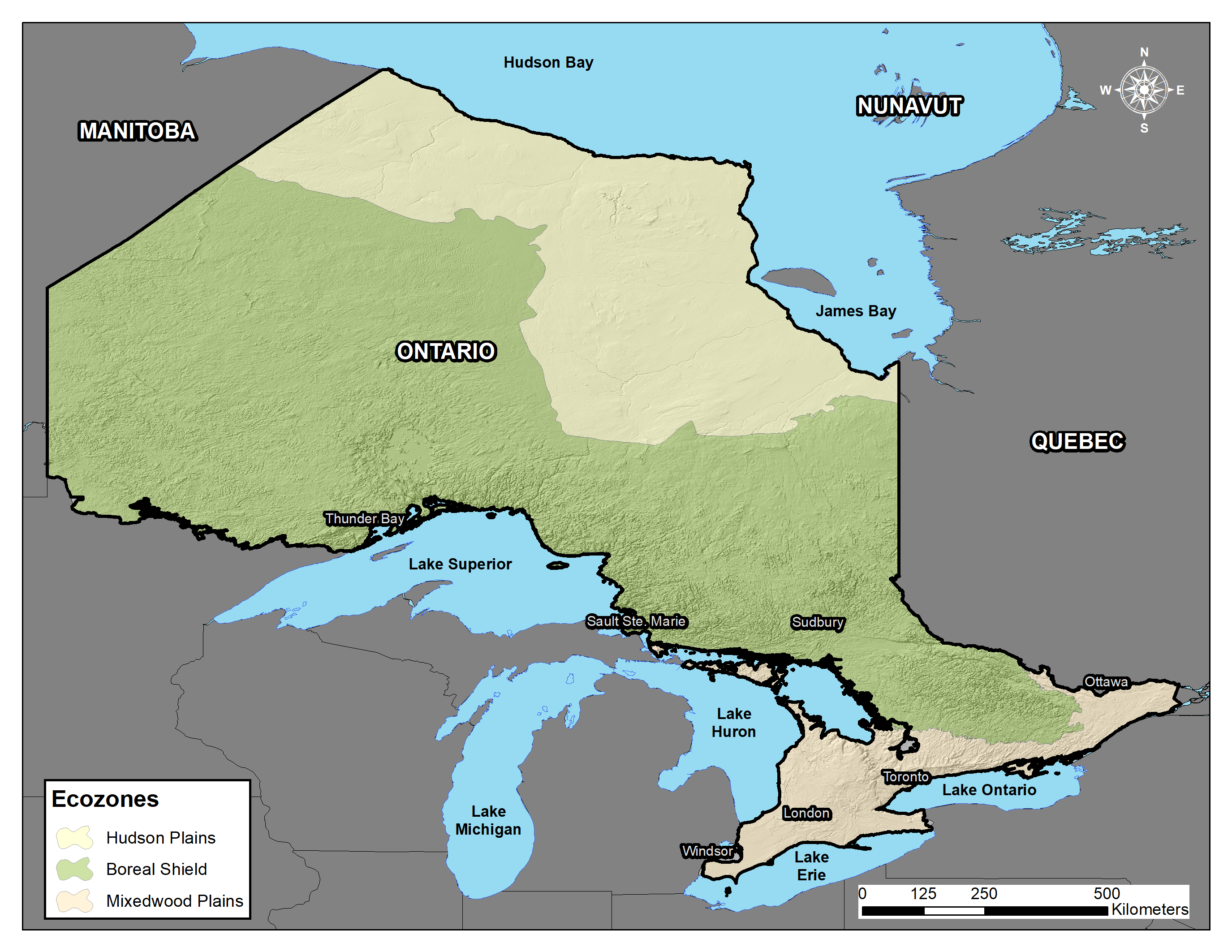
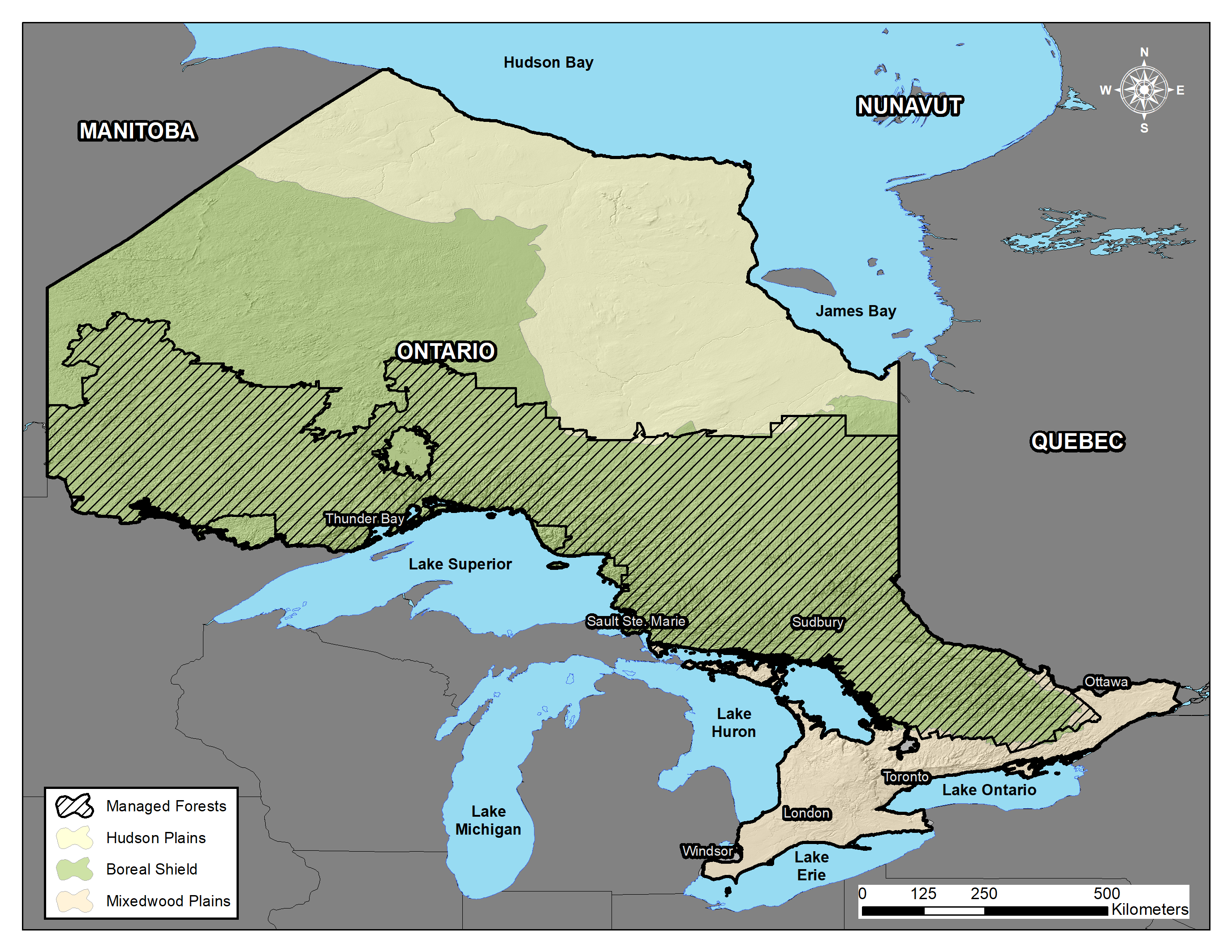
Broadly speaking, the distribution of Soil Orders in Ontario aligns with the terrestrial Ecozones of Canada as present in the province: the Hudson Plains Ecozone, the Boreal Shield Ecozone, and the Mixedwood Plains Ecozone. Bedrock geology, parent materials, climate and vegetation play key roles in governing this alignment and will be discussed in the following sections.
ECOZONES OF ONTARIO
Hudson Plains Ecozone
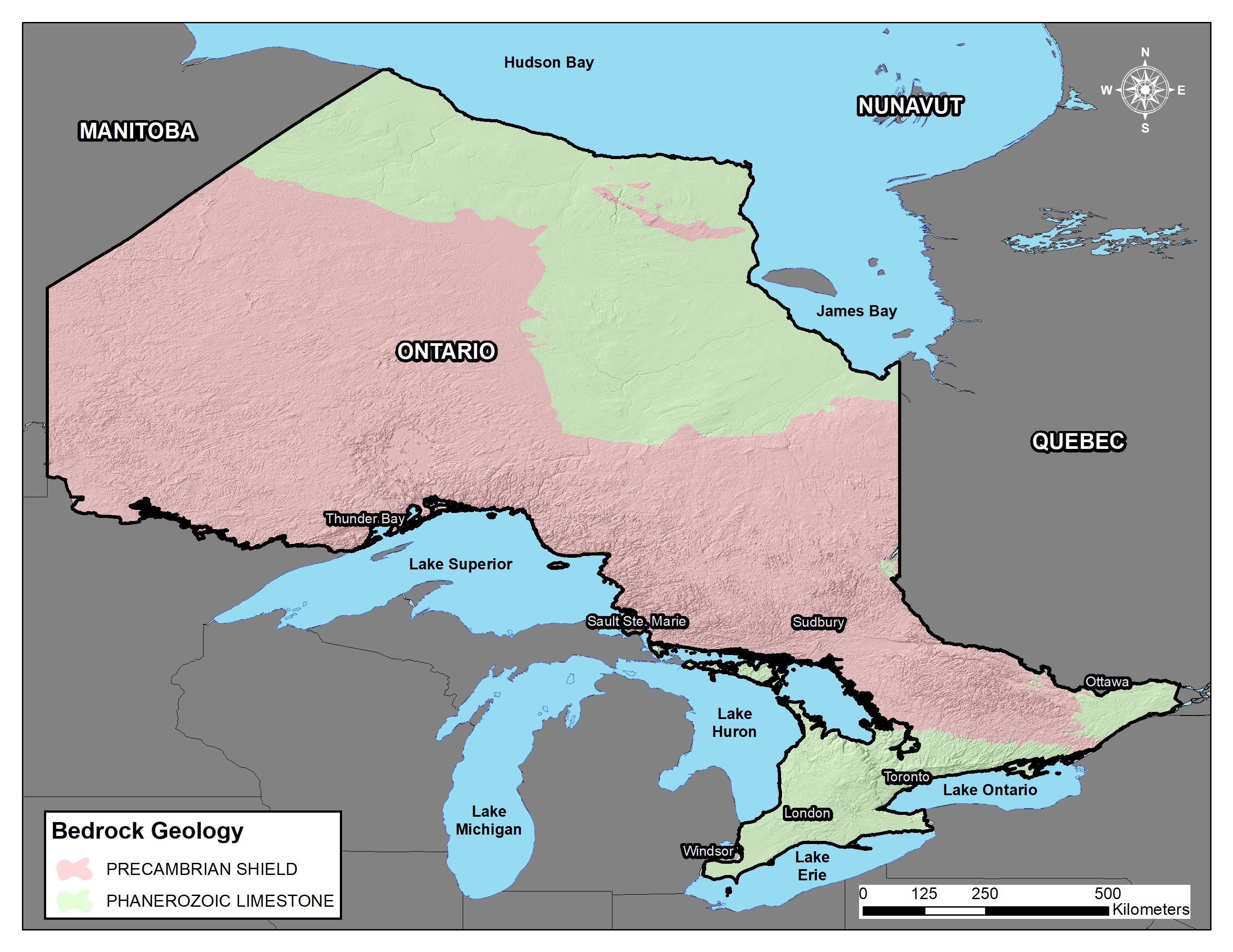
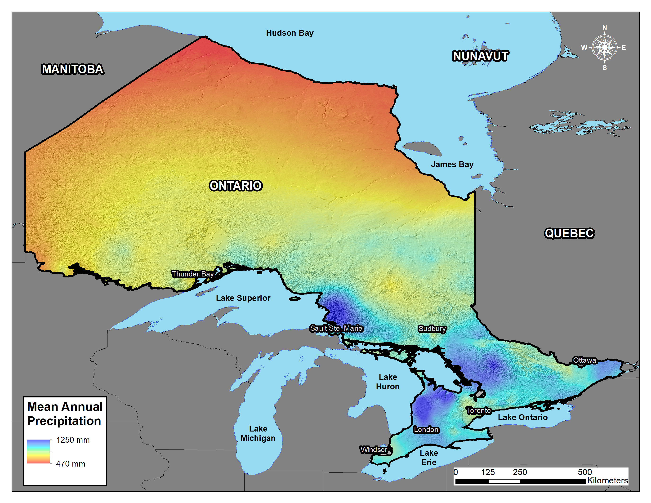
The Hudson Plains Ecozone, commonly referred to as the Hudson Bay Lowlands, occupies the northern portions of the province from the border with Manitoba in the west to the Quebec border in the east, and parallels the shores of Hudson Bay and James Bay (Figure 11.1). This ecozone comprises approximately 25% of the land area of Ontario, and has its southern limit marked by the boundary between mostly Paleozoic (541 to 252 million years ago [mya]) and Mesozoic (252 to 66 mya) limestones of the Phanerozoic Eon, which underlie the ecozone, and the Precambrian Shield (Figure 11.2, Crins et al. 2009). These rocks are softer than those of the Precambrian Shield and are neutral to alkaline in reaction (refer to Chapter 5: Soil pH for more information). The climate is described as relatively cold and semi-arid, with average annual temperature ranging from -6.2 to 7 °C (Figure 11.3, Fick and Hijmans 2017) and mean annual precipitation ranging from 240 to 525 mm (Figure 11.4, Stewart and Lockhart 2005). January and July mean daily air temperatures are between -20 to -27.5 °C and 12 to 16 °C, respectively. Generally speaking, the Hudson Plains Ecozone, as the name would suggest, is a relatively flat landscape characterized by poor drainage. After deglaciation, sea water flooded the landscape, depositing vast clay and silt deposits over the limestone bedrock. Isostatic rebound, the process of land surface uplift or recovery from the weight of the continental glacier, is visible by the sequence of beach ridges formed parallel to the modern shoreline of Hudson Bay. The rate of isostatic rebound is greatest along the shores of Hudson Bay, estimated at a rate of 13 mm per year (Henton et al. 2006). The vast flat landscape is dissected by major rivers that have carved into the landscape and empty into the marine waters of Hudson Bay and James Bay.

Boreal Shield Ecozone
The Boreal Shield Ecozone occupies a central band of the province, extending from the Manitoba border in the west, to the Quebec border in the east, and occupies approximately 66% of the province (Figure 11.1). The Boreal Shield Ecozone is bordered by Paleozoic limestone bedrock in the north and south (Figure 11.2). Bedrock is Precambrian, more specifically from the Archean Eon (formed 4000 to 2,500 mya) and is dominated by gneisses and granites. These rocks form a major portion of earth’s crust and are predominantly metamorphic rocks, formed when the Earth initially cooled enough to allow for molten rocks to solidify. These rocks are resistant to weathering, significantly more so than the neighboring limestones, and their reaction is typically acidic. The climate is described as relatively cold and moist, with average annual temperature increasing from -3.5 °C to 6.8 °C (Figure 11.3) and mean annual precipitation increasing from 517 mm to 1246 mm from west to the east across the ecozone. (Figure 11.4, Fick and Hijmans 2017). January and July mean daily air temperatures are -15 °C and 17 °C, respectively (Stewart and Lockhart 2005). The geographic extent of the ecozone is such that air temperatures can vary dramatically across the Boreal Shield, especially in proximity to the Great Lakes. Surficial deposits are complex and are dominantly the relics of the Wisconsinan Glaciation. Exposed bedrock, a result of the continental glacier scraping and relocating materials further south, is significant in extent and dominates large tracts of this landscape. Scattered throughout the bedrock exposures are morainal (till) deposits, glacio-fluvial deposits such as eskers and kames, glacio-lacustrine deposits from ancient lakes, and organic deposits. The thickness of these deposits varies considerably from thin veneers (10 to 100 cm) over bedrock to deep deposits many meters thick. This ecozone is known provincially as the Ontario Shield, and contains not only the conifer-dominated boreal forest, but also the important portions of Great Lakes-St. Lawrence forest region composed dominantly of deciduous hardwood forests.
Mixedwood Plains Ecozone
The Mixedwood Plains Ecozone occupies the most southern reaches of Ontario extending from the western tip of Lake Erie near Windsor, Ontario, to the Quebec border in the east, bounded by the Precambrian Shield to the north, Lake Huron to the west, and Lakes Erie and Ontario to the south (Figure 11.1). The bedrock that underlies the ecoregion is of the same origin as that of the Hudson Plains Ecozone: limestone and dolostone of Phanerozoic origin. It occupies the smallest area of the three ecoregions in Ontario; approximately 9% of the land surface. Despite the small footprint, this ecozone is the most extensively studied and managed area in Ontario, primarily because the major population centers are all located within this ecozone, and the most productive agricultural lands in Ontario (and Canada) are located here. For this reason, there is a disproportionate amount of data, and data of higher resolution, available in this part of the Province. The climate is described as cool to mild, having cool winters and warm summers, and is known to be one of the mildest climates in Canada (Crins et al. 2009), largely due to the moderating effects of the Great Lakes. January and July mean daily air temperatures range from -3 to -12 °C and 18 to 22 °C, respectively. Moisture is more abundant with the ecoregion receiving from 770 to 1,202 mm of precipitation annually, key to the development of soils which will be expanded upon in the subsequent sections. The surficial geology is extremely complex and has been the focus of numerous works (e.g., Chapman and Putnam 1984; Karrow and Calkin 1985). The Laurentide Ice Sheet began its retreat from Ontario along the southwestern peninsula which is currently surrounded by Lake Huron, Georgian Bay, Lake Erie and Lake Ontario. The ice split from southwest to northeast creating numerous ice lobes that retreated into today’s modern lake basins, all the while forming iterations of glacial lakes in the process at the foot of the glacier. This resulted in a series of terminal, interlobate and ground moraines, vast glacio-fluvial outwash plains and extensive glacio-lacustrine deposits. The retreat from southwestern Ontario also exposed the Niagara Escarpment, which arches from Niagara Falls to the tip of the Bruce Peninsula and the shorelines of Manitoulin Island. In the east, the Champlain Sea was formed and inundated portions of the Ottawa and St. Lawrence River valleys, depositing significant areas of glacio-marine sediment.
DISTRIBUTION OF SOILS IN ONTARIO
Soil distribution in the Hudson Plains Ecozone
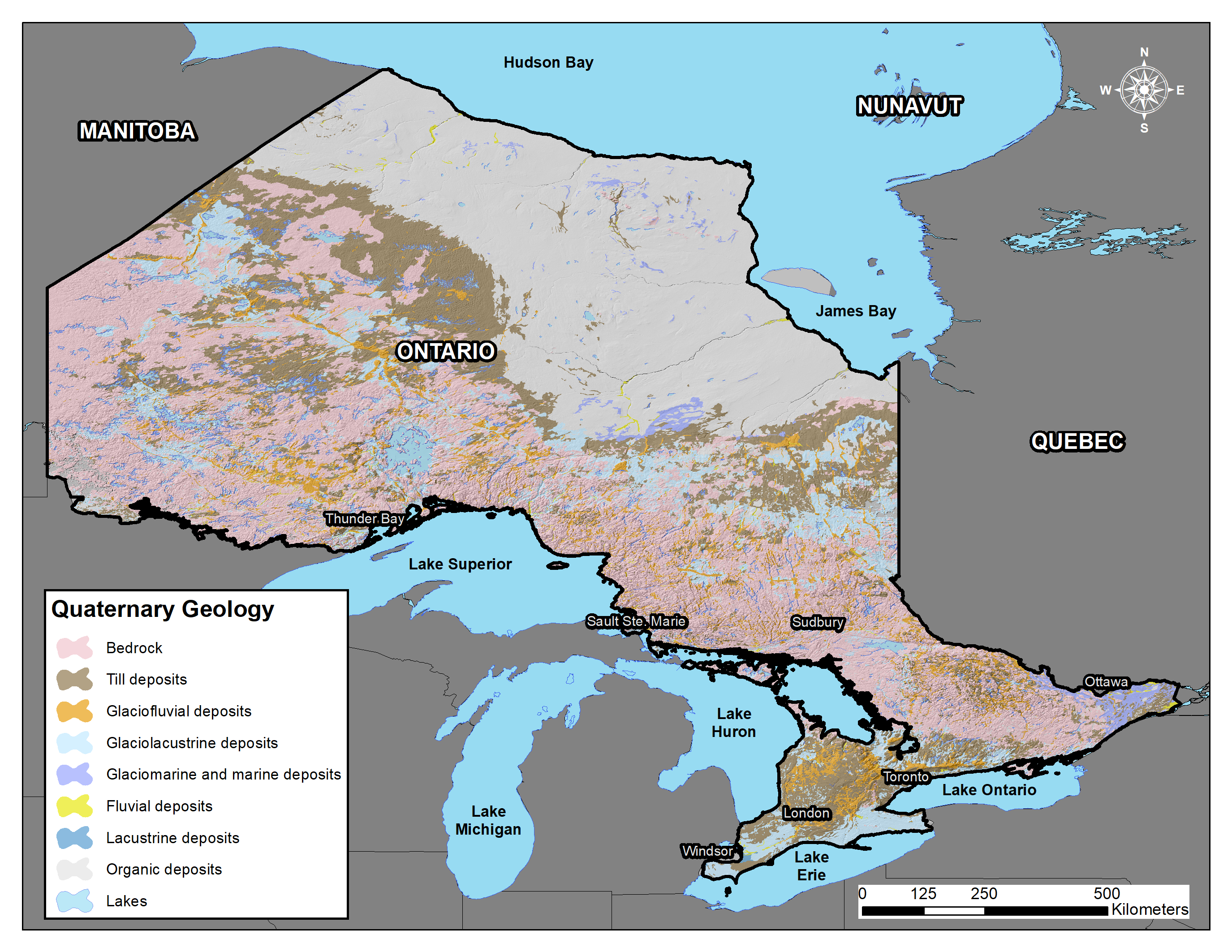
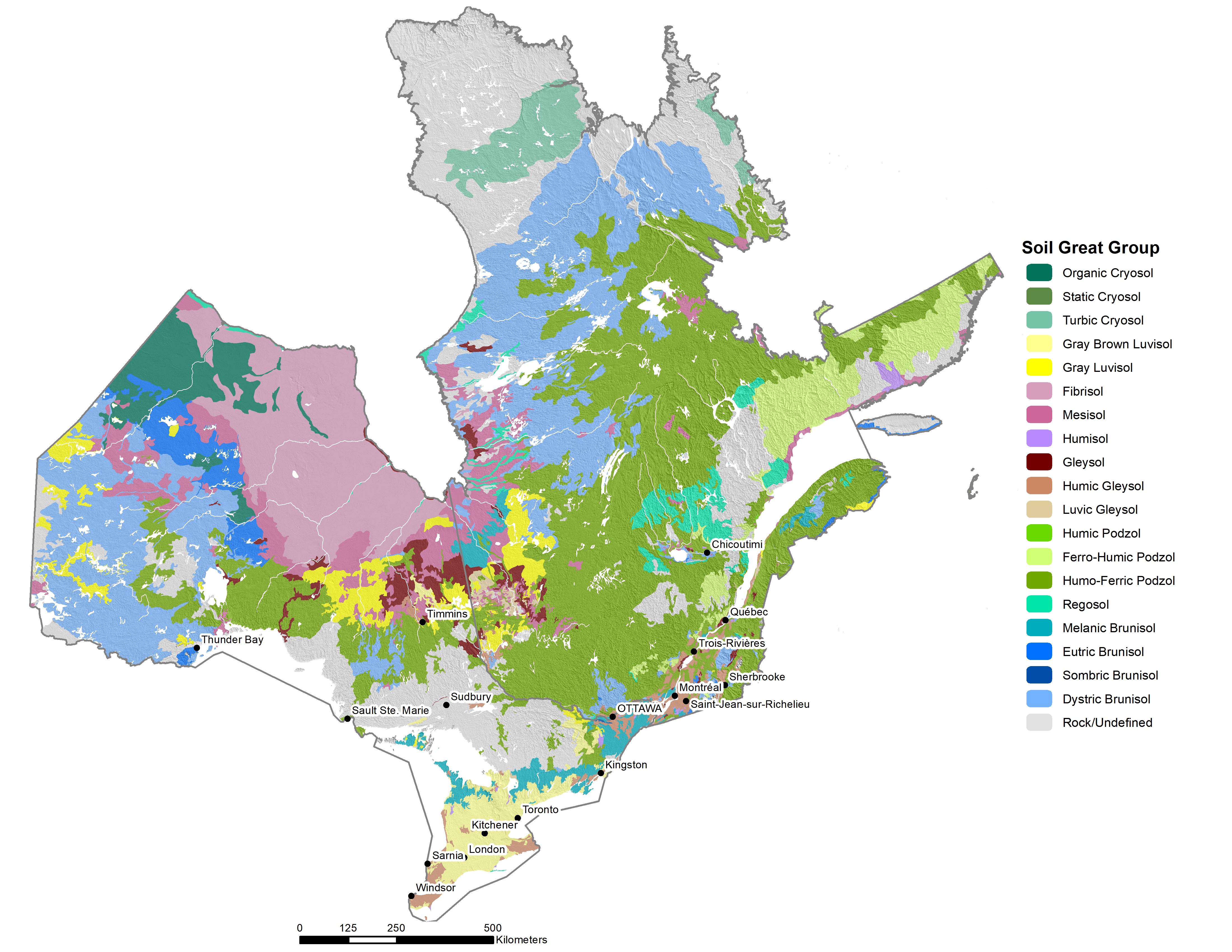
The distribution of soils in Ontario is controlled by the relative importance or dominance of soil forming factors, and in many cases one soil-forming factor overrides many others. This is the case for the soils in the Hudson Plains Ecozone. The cold, semi-arid climate is the single most important factor. Despite the relatively small amount of annual precipitation, the cold annual temperature and short growing season do not allow for high rates of evapotranspiration, leaving much of the moisture in the soil. This is exacerbated by the dominantly clayey and silty textured glacio-marine parent materials which have high water holding capacities. This results in soils that are saturated most of the year and favor the accumulation of organic materials at the surface (Figure 11.5). In addition, in the cooler northwest portions of the ecozone, mean annual temperatures are so low that permafrost is a common occurrence. These conditions result in soils of the Organic Order and Cryosolic Order being dominant (Figure 11.6). At the Great Group level, Fibrisols of the Organic Order constitute the majority of the ecozone. Fibrisols are characterized by materials composed of relatively undecomposed organic materials, developed mostly from sphagnum mosses (SCWG 1998) and contain >17% organic carbon. In terms of taxonomy, Fibrisols have a dominantly fibric middle tier (40–120 cm), or middle and surface tiers if a terric, lithic, hydric or cryic contact occurs in the middle tier (Kroetsch et al. 2011). Fibrisols dominate because the cool temperatures slow the rate of decomposition of organic materials dramatically, resulting in the organic materials rated as classes 1 to 4 on the von Post scale of decomposition (SCWG 1998). In field diagnostics, when samples are squeezed in the hand, fibric materials yield clear to yellow-brown water and the plant remains are relatively unaltered (Kroetsch et al. 2011). More decomposed materials (classified as Mesisols) are found sporadically in small pockets typically at the southern edge of the ecozone and bordering the Canadian Shield. Mesisols are characterized as dominantly composed of mesic organic materials, or those materials in classes 5 and 6 on the von Post scale of decomposition (SCWG 1998). The extreme northwest of the ecozone, bordering northeastern Manitoba, is dominated by Organic Cryosols. Organic Cryosols are soils developed from organic deposits, similar to the Fibrisols and Mesisols, but differ in that they also have permafrost within one metre of the surface.
Soil distribution in the Boreal Shield Ecozone
Soils of the Boreal Shield Ecozone are more diverse than those of the Hudson Plain Ecozone. Whereas the Hudson Plains Ecozone is dominated by one soil forming factor, climate, the distribution of Soil Orders across the Boreal Shield Ecozone is governed by climate, parent material, topography and vegetation. Some of these soil forming factors exert their influence on pedogenesis over large regional scales (e.g., precipitation, parent materials), while others exert their influence over short distances (e.g., topography or relief).
In the west, generally from Thunder Bay and Lake Nipigon to the Manitoba border, soils of the Dystric Brunisol Great Group dominate (Figure 11.6). Dystric Brunisols are juvenile soils with weak profile development that have a Brunisolic Bm, Bfj, or thin Bf diagnostic horizon less than 5 cm thick and an acidic reaction. Dystric Brunisols either have no Ah or a very thin Ah horizon and a pH (0.01 M CaCl2) in the upper 25 cm of the Bm horizon of <5.5 (Smith et al. 2011). The lack of an Ah horizon indicates conditions that favor mor humus forms, as opposed to mull or moder humus forms (see Chapter 2, section 2.6.1 for information on humus forms). These are forest soils generally formed on non-calcareous materials, typically transitional to Podzolic soils (Smith et al. 2011). In northwestern Ontario, these soils have developed on the sandy, acidic morainal deposits of the Canadian Shield. It should be noted that the Dystric Brunisols are interspersed with granitic bedrock outcrops, and in some areas the bedrock outcrops dominate as can be seen along the Manitoba border. Local depressions in the landscape are bedrock-controlled and therefore hold significant amounts of water, resulting in the development of Organic soils.
Northeast of Thunder Bay lies a band of soils dominated by the Humo-Ferric Podzol great group that parallel the north shore of Lake Superior, extending south of Timmins east to the Quebec border (Figure 11.6). The parent materials in this region are also sandy, non-calcareous, acidic morainal deposits of the Canadian Shield; but the Humo-Ferric Podzols are the succession soils of the Dystric Brunisols. Podzols in general are associated with parent materials that have low pH buffering capacity, vegetation that yields acidic litter materials (typically conifers), and climates where annual precipitation exceeds evapotranspiration, leading to a leaching environment (Sanborn et al. 2011). The difference from the western part of the Canadian Shield described above is the higher annual precipitation, most notably in proximity to and east of Lake Superior (Figure 11.4). Increased precipitation leads to increased leaching and movement of iron and aluminum into the B horizon.
A significant area north of Timmins, but south of the Hudson Plain, is dominated by Gray Luvisols, Gleysols and Mesisols; this area is known as the Great Clay Belt. The parent materials in this region were deposited by proglacial Lake Barlow-Ojibway, and consist dominantly of glacio-lacustrine clays and silts, and heavy-textured morainal (till) deposits (Figure 11.5). Numerous bedrock exposures dissect the clay plain; associated with the bedrock ridges are the heavy-textured morainal deposits. These deposits are neutral to alkaline, carbonated, base-saturated parent materials, with low hydraulic conductivity and are relatively stone free. These characteristics favour the development of Luvisolic soils in upper to mid landscape positions. Gleysolic soils occupy the lower landscape positions and organic soils of the Mesisol great group, those in the middle stage of decomposition, occupy level and depressional landscape positions. Luvisolic soils are typically formed in forest environments, more commonly in mixedwood and deciduous forests, and in areas of sub-humid to humid moisture regimes and mild to very cold climates (Lavkulich and Arocena 2011). Diagnostics properties of Gray Luvisols include an eluvial Ae horizon and an illuvial Bt horizon, characteristic of the removal of clay from the Ae with subsequent deposition in the Bt horizon (Lavkulich and Arocena 2011). This translocation is evident by the increased clay content of the Bt horizon and visible clays skins on the peds of the Bt horizon.
Poorly-drained soils of the Gleysol subgroup occupy significant areas in this region. The great groups of the Gleysolic Order reflect the occurrence (or absence) of additional processes beyond that of the primary gleying process (Bedard-Haughn 2011). The Gleysol great group is a great group of the Gleysolic Order that has no secondary process; therefore, these soils are characterized simply by the occurrence of anaerobic conditions inferred by soil color and/or the presence of a water table (see Chapter 8). The clayey deposits of the Great Clay Belt favor water retention due to low hydraulic conductivities and infiltration rates, resulting in poor drainage conditions and the development of Gleysols. Another important factor is the dominantly level topography of the Great Clay Belt which leads to poor external drainage, which exacerbates the internal drainage conditions. Gleysols are widespread in the Great Clay Belt and occur in lower slope positions in morainal and glacio-lacustrine deposits, and in level areas of the clay plain. Mesisols account for the remainder of the dominant soils in the area, and, as previously described, are composed of organic deposits in the middle stages of decomposition on the von Post scale (classes 5 and 6). These soils occupy the vast low-lying and level portions of the landscape and typically support wetland communities.
The remaining portion of the Boreal Shield Ecozone, extending east from Sault Ste. Marie to the Quebec border, is dominated by exposed bedrock. This area of the shield contains exposed rock and thin drift (till) over bedrock of varying thickness. In the till deposits, materials are non-calcareous and acidic, and Dystric Brunisols and Humo-Ferric Podzols develop in complex associations with the bedrock. These types of landscapes are often described in soil maps and reports with land types or land units, which are groupings of soils of varying proportions, due to the complexity and high variability of the soils.
Soil distribution in the Mixedwood Plains Ecozone
Similar to the Boreal Shield Ecozone, the distribution of soils across the Mixedwood Plains Ecozone is governed by parent material, topography and vegetation; however, climate plays a less important role in controlling soil distribution within the ecozone. Unlike the precipitation gradient that results in separation of the Brunisolic from Podzolic soils in the Boreal Shield, soil development in the Mixedwood Plains is more reliant on the distribution of parent materials, or surficial deposits. The Mixedwood Plains Ecozone is primarily underlain by Paleozoic limestones, and as such, the parent materials are carbonate rich and typically neutral to alkaline in reaction. This provides the foundation for soil development.
Extensive glacio-lacustrine plains occur in southwestern Ontario north of Lake Erie (Figure 11.5). These are remnants of numerous iterations of glacial lakes that formed during the retreat of the Laurentide Ice Sheet. These areas correlate with areas dominated by Humic Gleysols (Figure 11.6). Soils of the Humic Gleysol great group differ from those of the Gleysol great group (previously described) due to the presence of a thick Ah (>10 cm) or Ap (>15 cm) horizon (Bedard-Haughn 2011) which indicates incorporation and decomposition of organic matter in the surface horizon (see Chapter 8: Wetland Soils for more information on Gleysols). Similar to the soils of the Great Clay Belt, these glacio-lacustrine plains are predominantly composed of clay-dominated materials, with areas of clay-rich tills deposited as a result of glacial re-advance over previously deposited glacio-lacustrine clays. The heavy-textured soils have low infiltration rates, low hydraulic conductivity, and the level landscape limits external drainage, resulting in development of Humic Gleysols. The remainder of the southwest peninsula of Ontario, and east along the north shore of Lake Ontario, is largely dominated by Gray Brown Luvisols. In terms of diagnostic properties, the Gray Brown Luvisols share the same as the Gray Luvisols (described above), however Gray Brown Luvisols have an Ah (mull) horizon at the surface (Lavkulich and Arocena 2011) which differentiates them from Gray Luvisols. Despite evidence that organic matter and decomposition differ between Gray and Gray Brown Luvisols, there is no general consensus on the influence on pedogenesis (Lavkulich and Arocena 2011); however, it is recognized that Gray Brown Luvisols form in deciduous-dominated hardwood forests of eastern Canada (maple, oak, ash) and that the Ah forms from the mixing of organic matter with the mineral surface due to faunal activity, primarily earthworms. A review of the Quaternary geology of Ontario map (Figure 11.5) reveals that the areas mapped as Gray Brown Luvisols are predominantly composed of morainal and glacio-fluvial deposits. The till deposits are mainly medium textured, while the glacio-fluvial deposits vary from moderately coarse to very coarse textured. Both are calcareous parent materials, hence the trajectory to Luvisolic soils and not Podzolic soils.
North of the Gray Brown soils, in a narrow band running east-west, is an area of Melanic Brunisols. This area is at the intersection of the Canadian Shield metamorphic bedrock to the north and the Phanerozoic limestone bedrock to the south and is dominated by thin morainal deposits over bedrock. These morainal deposits are a mix of the granitic materials originating from the Shield and the medium-textured calcareous materials from the limestone, and as such the materials are moderately coarse in texture, can contain significant coarse fragments from gravel to stone in size, and are neutral to alkaline in reaction with calcareous parent material. This combination results in the formation of Melanic Brunisols. Brunisols are differentiated at the great group level based on the presence or absence of an Ah horizon ≥10cm in thickness and the pH of the underlying Bm horizon. For the Melanic Brunisols, the Ah horizon ≥10 cm thick is present, and the Bm has a pH ≥5.5 (0.01M CaCl2) in the upper 25 cm (Smith et al. 2011). These soils occur in association with the Gray Brown Luvisols and have a similar mull surface horizon originating from the incorporation of forest litter. In this region, the parent materials are extremely calcareous, and more time is required to neutralize and remove the carbonates from the upper solum, which limits soil development and results in truncated or shallow soil profiles with carbonates occurring much closer to the surface than in the Gray Brown Luvisols to the south. East of Kingston, Ontario, and towards Ottawa is another region dominated by the Melanic Brunisols. These are developed mostly in the Grenville till, found east of the Frontenac Axis. The Frontenac Axis is an intrusion of Canadian Shield bedrock that dissects the Phanerozoic bedrock just east of Kingston. It should be noted that even though Brunisols dominate the Grenville till, lower lying areas and depressions contain Humic Gleysols.
Finally, the areas surrounding Ottawa and the confluence of the Ottawa and St Lawrence rivers are dominated by Humic Gleysols. These soils are developed in glacio-marine deposits from the Champlain Sea that inundated the region when it was depressed or lowered by the weight of the ice (isostatic depression) during glaciation and subsequent rebound after deglaciation. These materials are clay-rich, and for reasons previously explained, favor the development of Gleysolic soils. Champlain Sea clays are unique in that they were deposited in a brackish, or saline, marine environment. The salts deposited with the clays had positive charges binding the negatively charged clay particles together into a stable mass. When saline waters retreated and the materials were exposed to precipitation, the salts were dissolved and leached from the clays, in some cases being reduced from upwards of 30 g/l down to <1 g/l (Geertsema 2013). The increase in the repulsive forces between clay particles as a result of reduced salinity can render the clays unstable and susceptible to landslides and mass wasting. More than 250 landslides have been mapped in these clay deposits in Canada (see Chapter 12: Soils of Quebec for additional information on the Champlain Sea clay deposits). These clays are commonly referred to as quick clay or Leda Clay.
LAND USE
Land use in the Hudson Plains Ecozone
The Hudson Plains Ecozone is relatively untouched and pristine. It is dominated by sparse, slow-growing vegetation in bog and fen environments, dominated by black spruce, tamarack and birch. These low productivity forests are not suitable for commercial forest harvesting operations. The Ecozone is remote—there is little to no transportation infrastructure in place to access the region. Settlements are located along the coasts of Hudson Bay and James Bay, along major rivers, from which most derive their names. These include Fort Severn, Peawanuck (Severn), Attawapiskat, Fort Albany, Moosonee and Moose Factory. These settlements are only accessible by air or water, with the exception of Moosonee which is serviced by rail. Ontario’s only diamond mine is located less than 100 kilometers west of Attawapiskat, but it is set to end production by the end of 2019. The Hudson Plains Ecozone is home to Polar Bear Provincial Park, Ontario’s largest Provincial park, located along the shores of Hudson Bay and James Bay.
Land use in the Boreal Shield Ecozone
The Boreal Shield Ecozone is known for its abundance of natural resources, making it an ideal setting for the forestry and mining sectors. Ontario has 71 million hectares of forests, of which 43 million hectares are crown forests managed by the Ontario Ministry of Natural Resources (OMNR 2016). These managed forests are located mostly within the Boreal Shield Ecozone (Figure 11.7). The forest sector supports local communities, creating on average 51,660 direct jobs annually (OMNR 2016). Crown forests are managed in administrative zones (forest management units) and through forest management plans.
The mining sector plays an important role in the Boreal Shield, mostly through extraction of various precious metals from the Precambrian Shield bedrock. In 2019, there were 39 active mines in Ontario, of which 33 were located in the Boreal Shield. Of these, 18 were gold mines, nine were base metal mines, one iron mine, one platinum mine and four industrial mineral operations (Ontario Mining Association-OMA 2019). The industry sustains 26,000 direct jobs and over 50,000 indirect jobs in the province and boasted a $10.1 billion value of mineral production in 2018 (OMA 2019). Mining operations span the entire Boreal Shield, but the areas surrounding Timmins, Sudbury and Wawa have the most intensive operations. A new major mining project, known as the Ring of Fire, located in northwestern Ontario, north of Thunder Bay, is currently under development.
Agricultural land use is not widespread in the Boreal Shield, but rather occupies smaller pockets of land scattered throughout the ecozone. These small pockets of agricultural land are typically associated with soils formed on deposits other than the coarse-textured morainal deposits of the Shield (e.g., glacio-lacustrine deposits from proglacial Lakes Agassiz, Barlow-Ojibway and Nipissing). Agricultural production is predominantly focused on livestock production, due to short growing seasons and less fertile soils; however, a warming climate has seen a transition from hay and livestock to cash crops such as corn, soybean, canola and small grains in Temiskaming Shores, Nippissing and Algoma.
Land use in the Mixedwood Plains Ecozone
A large portion of the Mixedwood Plains Ecozone has been converted from natural forests to agricultural production and urban settlements (Figure 11.8); it is the most densely populated ecozone in Canada (Crins et al. 2009). In 2018, agriculture accounted for 53.2% of the land use in the ecozone (Table 11.1), or approximately 4.5 million hectares of land (AAFC 2018). Forests accounted for over 23% of the ecozone (11.5% broadleaf, 8.4% mixedwood and 3.4% conifer), and urban or developed land covered over 11% (934,898 ha). Cash crops dominate the agricultural landscape, the largest three crops being soybeans, grain corn and cereals, primarily winter wheat (AAFC 2017). The clayey glacio-lacustrine plains of the far southwest, the Niagara Region above the Niagara Escarpment and the Ottawa Valley are dominated by corn, soybean and winter wheat crops. These areas are extensively drained by systematic tile drainage systems and/or networks of surface drains, which also serve as outlets for the tile drainage systems. Without drainage, the soils in this area would have limited agricultural production due to excess water. The area between the Niagara Escarpment and Lake Ontario is home to a thriving specialty crop industry that includes vineyards, orchards (apples, pears), tender fruit production (peaches, plums, cherries, apricots, etc.) and greenhouses (vegetables and floral industry). In winter, warm air over Lake Ontario rises, and the northerly winds push the air inland towards the Niagara Escarpment. This displacement of air results in cool air being drawn off the land surface and out towards the lake, creating a circular system which moderates the winter climate. The central part of southwestern Ontario, dominated by undulating morainal hills and glacio-fluvial deposits, is also dominated by corn, soybean and winter wheat cash crop operations. Moving northward toward the Bruce Peninsula, the rolling topography becomes steeper and cropping operations give way to cattle production with more land in pasture and forages.
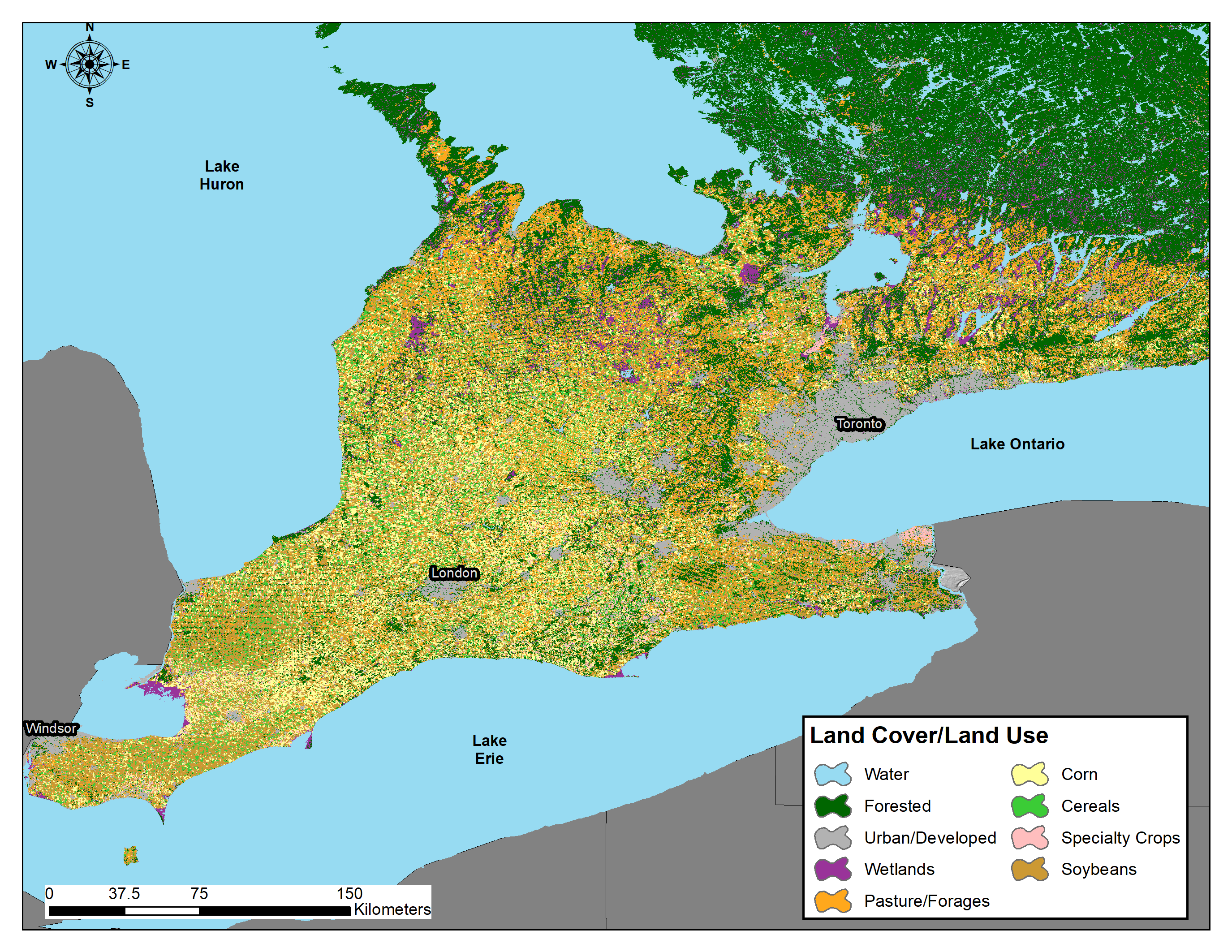
Tableau 11.1. Summary of land use in the Mixedwood Plains Ecozone based on Agriculture and Agri-Food Canada's 2018 Annual Crop Inventory (AAFC 2019).
| Land Use | Area (hectares) | Area (acres) | % of total |
|---|---|---|---|
| Agricultural | |||
| Pasture / Forages | 1,501,517 | 3,708,747 | 17.9 |
| Soybeans | 1,296,229 | 3,201,685 | 15.4 |
| Corn | 1,064,740 | 2,629,907 | 12.7 |
| Cereals | 495,040 | 1,222,748 | 5.9 |
| Vegetables | 38,752 | 95,718 | 0.5 |
| Specialty | 25,385 | 62,701 | 0.3 |
| Pulses | 25,108 | 62,016 | 0.3 |
| Fruits | 8,498 | 20,990 | 0.1 |
| Fallow | 6,797 | 16,788 | 0.1 |
| Oilseeds | 6,656 | 16,441 | 0.1 |
| Sod | 3,514 | 8,680 | 0 |
| Greenhouses | 2,148 | 5,306 | 0 |
| Other Crops | 230 | 569 | 0 |
| Subtotal | 4,474,614 | 11,052,295 | 53.2 |
| Native | |||
| Broadleaf | 963,805 | 2,380,597 | 11.5 |
| Mixedwood | 706,106 | 1,744,081 | 8.4 |
| Wetlands | 478,298 | 1,181,397 | 5.7 |
| Shrubland | 405,111 | 1,000,623 | 4.8 |
| Conifers | 283,120 | 699,306 | 3.4 |
| Subtotal | 2,836,439 | 7,006,005 | 33.7 |
| Developed | |||
| Urban/Developed | 934,898 | 2,309,199 | 11.1 |
| Subtotal | 934,898 | 2,309,199 | 11.1 |
| Water | |||
| Water | 158,144 | 390,615 | 1.9 |
| Subtotal | 158,144 | 390,615 | 1.9 |
| Grand total | 8,404,095 | 20,758,113 | 100 |
Canada Land Inventory – Soil Capability Classification for Agriculture
Land use planning in Ontario is subject to the Provincial Policy Statement (PPS), issued under section 3 of the Planning Act (Planning Act 1990). The PPS provides a series of policies that “set out the government’s land use vision for how we settle our landscape, create our built environment, and manage our land and resources over the long term to achieve livable and resilient communities” (Ontario 2020). Protection of agricultural land is afforded under Part V: Policies 2.0 Wise use and management of resources, Policy 2.3 Agriculture, which states:
“Prime agricultural areas shall be protected for long-term use for agriculture. Prime agricultural areas are areas where prime agricultural lands predominate. Specialty crop areas shall be given the highest priority for protection, followed by Canada Land Inventory Class 1, 2, and 3 lands, and any associated Class 4 through 7 lands within the prime agricultural area, in this order of priority.”
The Canada Land Inventory (CLI) was a federal-provincial program initiated in 1961 and administered under the Agricultural Rehabilitation and Development Act (DREE 1969), commonly referred to as ARDA (see Chapter 8, section 8.12 for general information on the CLI). The Soil Capability Classification for Agriculture (henceforth referred to as Agricultural Capability) under the CLI program is a seven-class interpretive system used to assess the impacts of climate, soil and topography on the potential for production of field crops. Capability classes range from Class 1 to Class 7, with increasing limitations to crop production (Table 11.2). Limitations are noted as subclasses in the system, and soils are assigned to a class based on the type and severity of limitations (subclasses) for crop production.
Table 11.2. Description and summary of CLI agricultural capability classes and subclasses in Ontario
| Capability Class | Description |
|---|---|
| Class 1 | No significant limitations in use for crops |
| Class 2 | Moderate limitations that reduce the choice of crops, or require moderate conservation practices |
| Class 3 | Moderately severe limitations that reduce the choice of crops or require special conservation practices |
| Class 4 | Severe limitations that restrict the choice of crops, or require special conservation practices and very careful management, or both |
| Class 5 | Very severe limitations that restrict their capability to producing perennial forage crops, and improvement practices are feasible |
| Class 6 | Unsuited for cultivation, but are capable of use for unimproved permanent pasture |
| Class 7 | No capability for arable culture or permanent pasture |
| Capability Subclass (Limitations) | |
| Subclass C | Adverse climate: This subclass denotes a significant adverse climate for crop production as compared to the "median" climate which is defined as one with sufficiently high growing-season temperatures to bring common field crops to maturity, and with sufficient precipitation to permit crops to be grown each year on the same land without a serious risk of partial or total crop failures. In Ontario this subclass is applied to land averaging less than 2300 Crop Heat Units. |
| Subclass D | Undesirable soil structure and/or low permeability: This subclass is used for soils which are difficult to till, or which absorb or release water very slowly, or in which the depth of rooting zone is restricted by conditions other than a high water table or consolidated bedrock. In Ontario this subclass is based on the existence of critical clay contents in the upper soil profile. |
| Subclass E | Erosion: Loss of topsoil and subsoil by erosion has reduced productivity and may in some cases cause difficulties in farming the land e.g. land with gullies. |
| Subclass F | Low natural fertility: This subclass is made up of soils having low fertility that is either correctable with careful management in the use of fertilizers and soil amendments or is difficult to correct in a feasible way. The limitation may be due to a lack of available plant nutrients, high acidity, low exchange capacity, or presence of toxic compounds. |
| Subclass I | Inundation by streams or lakes: Flooding by streams and lakes causes crop damage or restricts agricultural use. |
| Subclass M | Moisture deficiency: Soils in this subclass have lower moisture holding capacities and are more prone to droughtiness. |
| Subclass P | Stoniness: This subclass indicates soils sufficiently stony to hinder tillage, planting, and harvesting operations. |
| Subclass R | Consolidated bedrock: The occurrence of consolidated bedrock within 100 cm of the surface restricts rooting depth and limits moisture holding capacity. Conversely, in poorly drained soils the presence of the bedrock may, depending on depth, make artificial drainage impossible. |
| Subclass S | Adverse soil characteristics: This subclass denotes a combination of limitations of equal severity. In Ontario it has often been used to denote a combination of F and M when these are present with a third limitation such as T, E or P. |
| Subclass T | Topography: This subclass denotes limitations due to slope steepness and length. Such limitations may hinder machinery use, decrease the uniformity of crop growth and maturity, and increase water erosion potential. |
| Subclass W | Excess water: This subclass indicates the presence of excess soil moisture due to poor or very poor soil drainage. It is distinguished from Subclass I - water inundation which indicates risk of flooding from adjacent lakes or streams. |
Since completion of the program in the mid 1970s provincial governments have gradually modified the system to meet provincial needs. While these modifications provide information that is more relevant at the provincial level, the differences across jurisdictions would now likely preclude direct comparison of soils across provincial boundaries without a thorough review of the differences between modern rating systems. The subtleties typically reside in how subclass limitations are applied. For example, in Saskatchewan, Subclass C (climatic) limitations are assigned based on heat and moisture deficiencies (Shields et al., 1968), while in Ontario, Subclass C limitations are assigned simply based on crop heat units (OMAFRA 2020). There are also situations where the criteria are quite provincially specific. Take for example Subclass D, in Ontario, which is determined by the presence and depth at which soil materials with > 35% or > 60% clay are found, rules that are not found or adhered to in other Provinces.
Eleven subclasses are recognized in Ontario. A detailed description of the CLI system and its application in Ontario is maintained by the Ontario Ministry of Agriculture, Food and Rural Affairs (OMAFRA 2020). All soils in the province have been assigned an Agricultural Capability rating, and these ratings form the basis for the protection of agricultural lands in Ontario. Soils in Classes 1, 2 and 3 are designated as prime agricultural lands; the soil mapping in Ontario forms the basis for delineating prime agricultural areas, which contain predominantly prime lands, but also potentially areas of Classes 4 through 7. OMAFRA’s Agricultural System in Ontario’s Greater Golden Horseshoe (GGH) is a prime example of the integration of CLI Agricultural Capability ratings into land use planning and preservation of prime agricultural areas for future generations. The data is available through the Agricultural System Portal and provides base data to assist municipalities in the GGH with update to their Official Plans.
Ontario’s Provincial Soil
Did you know many provinces have designated a Provincial Soil? In Ontario, the provincial soil is the Guelph soil series, and it was officially named the provincial soil on November 30th, 2015. The Guelph soil is classified as a Brunisolic Gray-Brown Luvisol and is found on rolling hills and drumlins in Wellington County and surrounding areas, covering over 70,000 hectares. The Guelph series was the first soil described in the Preliminary Soil Survey of Southwestern Ontario, published in 1923, another reason for its selection as the provincial soil. In addition, the Guelph series is an agriculturally important soil, considered prime agricultural soil when not limited by slope, developed in loam to silt loam textured morainal materials, often with a loess cap that is free of stones.
SUMMARY
- Three Ecozones are found in Ontario:
- Hudson Plains Ecozone
- Boreal Shield Ecozone
- Mixedwood Plains Ecozone
- Major soil forming factors in Ontario are spatially distributed:
- Hudson Plains: cold climate; low annual precipitation; limestone-dominated bedrock; suficial deposits comprised of marine silts and clays with extensive organic deposits.
- Boreal Shield: annual precipitation and mean temperature gradients both increasing from west to east; igneous (Shield) dominated bedrock; surficial deposits comprised of morainal, glaciofluvial, glacio-lacustrine and organic material with extensive amounts exposed bedrock.
- Mixedwood Plains: mild climate with sufficient precipitation across the region with a slight decrease from west to east; limestone-dominated bedrock; surficial deposits comprised of glacio-lacustrine plains, morainal deposits, glaciofluvial outwash and glaciomarine plains.
- The dominant Soil Orders present in Ontario include:
- Cryosolic Order
- Brunisolic Order
- Gleysolic Order
- Luvisolic Order
- Organic order
- Podzolic Order
- The soil forming factors and soil great group distribution in Ontario are related:
- Cryosolic, Organic and Gleysolic soils dominate the Hudson Plains Ecozone due to the cool temperature and the clay and silt marine materials deposited after deglaciation.
- Brunisolic and Podzolic soils dominate the Boreal Shield Ecozone, with Dystric Brunisols in the western half, and Podzols in the eastern half linked to a precipitation gradient from west to east.
- The Mixedwood Plain Ecozone is dominated by Humic Gleysols which are associated with vast glacio-lacustrine and glacio-marine plains and depressional areas, and by Gray-Brown Luvisols which are associated with morainal deposits.
- Land use in Ontario:
- The Hudson Plains Ecozone is mostly pristine, with very little infrastructure to access the region.
- The Boreal Shield Ecozone is a resource-rich region in Ontario, and supports forestry, mining, and recreational opportunities.
- The Mixedwood Plains Ecozone is the most densely populated ecozone in Canada and is an important agricultural region.
- Human interaction with the environment is intricately linked to soil distribution in Ontario, as it is around the world.
- The cold, wet, and sometimes frozen soils of the Hudson Plain Ecozone do not provide opportunities for resource extraction or agricultural development, as thus the region remains relatively undisturbed by direct human activities.
- The acidic, shallow, and low fertility soils of the Boreal Shield Ecozone are not suitable for agricultural development, and therefore support resource extraction and smaller urban settlements.
- The neutral to alkaline, fertile soils and mild climate of the Mixedwood Plains Ecozone are ideal for a vast agricultural sector and large urban settlements it supports.
REFERENCES
Agriculture and Agri-Food Canada (AAFC). 2019. Annual Crop Inventory 2018. [Online]. Available: https://open.canada.ca/data/en/dataset/ba2645d5-4458-414d-b196-6303ac06c1c9 [11 December 2019].
Bedard-Haughn, A. 2011. Gleysolic soils of Canada: Genesis, distribution, and classification. Canadian Journal of Soil Science. 91: 763-770. doi:10.4141/CJSS10030.
Chapman, L.J. and Putnam, D.F. 1984. The physiography of Southern Ontario. Ontario Geological Survey. Special Volume 2, 270pp.
Crins, W.J., Gray, P.A., Uhlig, P.W.C., and Wester, M.C. 2009. The Ecosystems of Ontario, Part 1: Ecozones and Ecoregions. Ontario Ministry of Natural Resources, Peterborough, Ontario, Inventory, Monitoring and Assessment, SIB TER IMA TR-01. 71pp.
Department of Regional Economic Expansion. 1969. The Canada Land Inventory Soil Capability Classification for Agriculture. Report No. 2. 16pp.
Fick, S.E. and Hijmans, R.J. 2017. WorldClim 2: new 1-km spatial resolution climate surfaces for global land areas. Int. J. Climatol. 37: 4302-4315.
Geertsema, M. 2013.Quick clay. In Bobrowsky, P.T. (eds) Encyclopedia of Natural Hazards. Encyclopedia of Earth Sciences Series. Springer, Dordrecht. DOI: https://doi.org/10.1007/978-1-4020-4399-4_282
Henton, J.A., Craymer, M.R, Ferland, R., Dragert, H., Mazzotti, S. and Forbes, D.L. 2006. Crustal motion and deformation monitoring of the Canadian landmass. Geomatica. 60(2): 173-191.
Karrow, P.F. and Calkin, P.E., eds. 1985. Quaternary Evolution of the Great Lakes. Geological Association of Canada Special Paper 30. 258pp.
Kroetsch, D.J., Geng, X., Chang, S.X. and Saurette, D.D. 2011. Organic soils of Canada: Part 1. Wetland organic soils. Canadian Journal of Soil Science 91: 807-822. doi:10.4141/CJSS10043.
Lavkulich, L.M. and Arocena, J.M. 2011. Luvisolic soils of Canada: Genesis, distribution, and classification. Canadian Journal of Soil Science 91: 781-806. doi:10.4141/CJSS2011-014.
Ontario Mining Association. 2019. Ontario Mining. [Online]. Available: https://www.oma.on.ca/en/ontariomining/OntarioMining.asp [ 11 December 2019]
Ontario Ministry of Agriculture, Food and Rural Affairs. 2020. Classifying prime and marginal agricultural soils and landscapes: guidelines for the application of the Canada Land Inventory in Ontario. [Online]. Available: http://www.omafra.gov.on.ca/english/landuse/classify.htm [7 February 2020].
Ontario Ministry of Natural Resources. 2016. State of Ontario’s Natural Resources – Forests 2016. Queen’s Printer for Ontario. Sault Ste. Marie, ON.
Ontario. Planning Act, RSO 1990. c.P.13. [Online]. Available: https://www.ontario.ca/laws/statute/90p13 [ 11 February 2020]
Sanborn, P., Lamontagne, L. and Hendershot, W. 2011. Podzolic soils of Canada: Genesis, distribution, and classification. Canadian Journal of Soil Science 91: 843:880. doi:10.4141/CJSS10024
Shields, J.A., Rostad, H.P.W., and Clayton, J.S. 1968. A guide to soil capability and land inventory maps in Saskatchewan (Second Edition). Publication No. M8. Saskatchewan Institute of Pedology. University of Saskatchewan. Saskatoon, Saskatchewan. 57pp.
Smith, C.A.S, Webb, K.T., Kenney, E., Anderson, A. and Kroetsch, D. 2011. Brunisolic soils of Canada: Genesis, distribution, and classification. Canadian Journal of Soil Science 91: 695-717. doi:10.4141/CJSS10058.
Soil Classification Working Group (SCWG). 1998. The Canadian System of Soil Classification. Agriculture and Agri-Food Canada. Publication 1646 (Revised). 187pp.
Statistics Canada. 2017. Cropland in Ontario grows despite fewer farms. Published by authority of the Minister responsible for Statistics Canada, Minister of Industry. Ottawa, ON. 9p.
Stewart, D.B. and Lockhart, W.L. 2005. An overview of the Hudson Bay marine ecosystem. Canadian Technical Report of Fisheries and Aquatic Sciences 2586, Fisheries and Oceans Canada, Winnipeg, Manitoba. 487pp.
About the Authors
Daniel Saurette, Environmental Management Branch, Ontario Ministry of Agriculture, Food and Rural Affairs; School of Environmental Sciences, University of Guelph
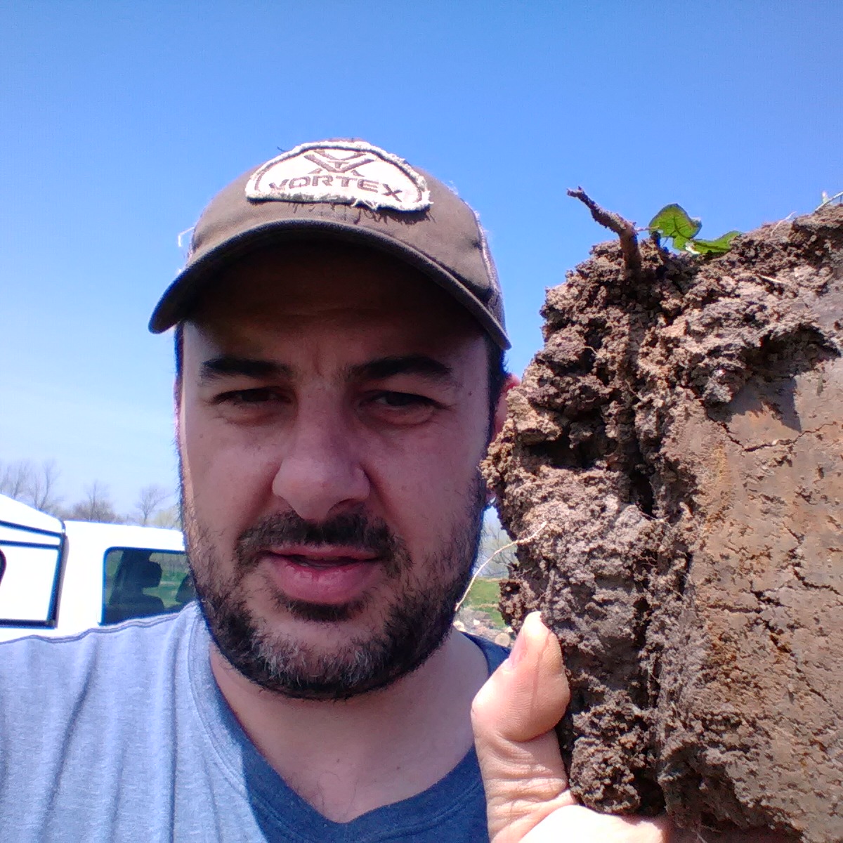
Dan’s work focuses on soil survey, mapping and classification. Typically, I would be referred to either as a Pedologist, or Soil Surveyor. My work involves planning field campaigns to describe soil profiles, classify them, sample the soil to determine chemical and physical properties in the lab, and then interpret the data to develop soil maps. Traditionally this was done with the aid of air photos, but more recently the discipline has shifted to Predictive Digital Soil Mapping where we leverage the power of machine learning and geographic information systems (GIS) to create high-resolution digital soil maps.
Jim Warren, Environmental Management Branch, Ontario Ministry of Agriculture, Food and Rural Affairs
Dr. Jim Warren P.Geo. is an environmental soil scientist with a diverse background in research, consulting and teaching. He is a graduate of both the University of Guelph (B.Sc. (Agr), Soil Science), and the University of Alberta (M.Sc. Soil Science; Ph.D. Soil Chemistry). He conducted research in agronomy, geochemistry, and mineralogy at the University of Guelph and University of Waterloo before becoming a private consultant in acid mine drainage. He is currently employed as a Land Resource Specialist conducting soil survey and pedology work with the Ontario Ministry of Agriculture Food and Rural Affairs He is also an Adjunct Professor with the University of Guelph. He has delivered courses in soil science, soil mineralogy, soil chemistry, geochemistry, and pedology as a sessional lecturer at four universities (Alberta, Guelph, Waterloo, and Toronto). He has authored or co-authored over 100 publications in refereed journals; book chapters, conference proceedings and reports.
Richard Heck, Professor, School of Environmental Sciences, University of Guelph

Growing-up on a farm in south central Saskatchewan, I became aware of issues like soil salinity, wind erosion and variable crop production across the landscape. As I took my undergraduate courses, I came to understand the wonderful complexity, diversity and importance of soil. Ultimately, I chose to pursue a career in soils, and specifically in pedology. Over the years, I have had the opportunity to experience and study soils in various temperate, subtropical and tropical ecosystems. While my early work focussed on soil chemical and mineralogical characteristics, my more recent work is directed at quantifying soil structure and microstructure, within which the various soil processes function, as well as understanding the variability of soil magnetic susceptibility, as a means of aiding in delineating soilscape moisture dynamics. The emphasis of my teaching is on helping the next generation also appreciate, by getting their hands ‘dirty’, the diversity of soils in our managed and natural landscapes.
The unconsolidated and more or less chemically weathered mineral or organic matter from which the solum of a soil has developed by pedogenic processes. The classes of genetic materials for unconsolidated mineral materials used in soil surveys in Canada are anthropogenic, colluvial, eolian, fluvial, lacustrine, marine, morainal, saprolite, volcanic ash, and undifferentiated; and for the organic materials there are bog, fen, swamp, and undifferentiated organic material.
Pertaining to alluvium.
Descriptive of materials transported and deposited by flowing water; growing or living in a stream or river; produced by the action of a stream or river.
(1) Pertaining to lakes. (2) Descriptive of materials that either have settled from suspension in bodies of standing fresh water or have accumulated at their margins through wave action.
Pertaining to materials deposited by wind.
Sediments generally consisting of medium to fine sand and coarse silt. They are well sorted, poorly compacted, and may show internal structures such as cross bedding or ripple laminae, or may be massive. These materials have been transported and deposited by wind action. (SCWG1998)
An area of the Earth's surface representative of large and very generalized ecological units characterized by interactive and adjusting abiotic and biotic factors. The ecozone defines, on a subcontinental scale, the broad mosaics formed by the interaction of macroscale climate, human activity, vegetation, soils, and geological and physiographic features of the country. Fifteen ecozones are recognized in Canada: Tundra Cordillera, Boreal Cordillera, Montane Cordillera, Boreal Plains, Taiga Plains, Prairie, Taiga Shield, Boreal Shield, Hudson Bay Plains, Mixed Wood Plains, Pacific Maritime, Atlantic Maritime, Southern Arctic, Northern Arctic, and Northern Cordillera.
(1) A soil separate consisting of particles <0.002 mm in equivalent diameter. (2) A textural class. (3) A naturally occurring material, composed primarily of fine-grained minerals, which is generally plastic at appropriate water contents and will harden when dried or fired. Although clay usually contains phyllosilicates, it may contain other materials that impart plasticity and harden when dried or fired. Associated passes in clay may include materials that do not impact plasticity and organic matter.
(1) A soil separate consisting of particles between 0.05 and 0.002 mm in equivalent diameter. (2) A soil texture class.
The rise of land masses that were depressed by the huge weight of ice sheets during the last ice age.
Relating to material deposited by glacial ice. Their structure varies from relatively loose near the surface, to very compact at depth.
Descriptive of material moved by glaciers and subsequently sorted and deposited by streams flowing from the melting ice. The deposits are stratified and may occur in the form of outwash plains, deltas, kames, eskers, and kame terraces.
(geomorphology) A serpentine ridge of roughly stratified gravel and sand that was deposited by a stream flowing in or beneath the ice of a stagnant or retreating glacier and was left behind when the ice melted. Length ranges from less than 100 m to more than 500 km (including gaps), and in height from 3 m to more than 300 m.
(geomorphology) A mound, knob, or short irregular ridge, composed of stratified sand and gravel deposited by a sub-glacial stream as a fan or delta at the margin of a melting glacier, by a supraglacial stream in a low place or hole on the surface of the glacier, or as a ponded deposit on the surface or at the margin of a stagnant ice.
Pertaining to, derived from, or deposited in glacial lakes; especially said of the deposits and landforms composed of suspended material brought by meltwater streams flowing into lakes bordering the glacier, such as deltas, kame deltas, and varved sediments.
Descriptive of compact, unstratified, silty to clayey sediments laid down in near-shore environments during glacial recession that were subsequently exposed through isostatic rebound. Deposits contain variable amounts of stones, gravels, and cobbles released from floating ice; and these coarse fragments are embedded in the fine-textured matrix of these deposits.
A scale describing peat in varying stages of decomposition, ranging from H1, which is unconverted, to H10, which is completely decomposed.
1-Undecomposed; plant structure unaltered; yields only clear water colored light yellow-brown.
2-Almost undecomposed; plant structure distinct; yields only clear water colored light yellow-brown.
3-Very weakly decomposed; plant structure distinct; yields distinctly turbid brown water, no peat substance passes between the fingers, residue not mushy.
4-Weakly decomposed; plant structure distinct; yields strongly turbid water, no peat substance escapes between the fingers, residue rather mushy.
5-Moderately decomposed; plant structure clear but becoming indistinct; yields much turbid brown water, some peat escapes between the fingers, residue very mushy.
6-Strongly decomposed; plant structure somewhat indistinct but clearer in the squeezed residue than in the undisturbed peat; about one-third of the peat escapes between the fingers, residue strongly mushy.
7-Strongly decomposed; plant structure indistinct but recognizable; about half the peat escapes between the fingers.
8-Very strongly decomposed; plant structure very indistinct; about two-thirds of the peat escapes between the fingers, residue almost entirely resistant remnants such as root fibers and wood.
9-Almost completely decomposed; plant structure almost unrecognizable; nearly all the peat escapes between the fingers.
10-Completely decomposed; plant structure unrecognizable; all the peat escapes between the fingers.
Organic materials that are readily identifiable as to botanical origin. Fibric material usually is classified on the von Post scale of decomposition as class 1 to class 4. (SCWG 1998)
(1) A soil temperature regime that has mean annual soil temperate of 8°C or more but <15°C, and >5°C difference between mean summer and mean winter soil temperatures at 50 cm below the surface. (2) Mesic peat is organic material at a stage of decomposition between that of fibric and humic materials; peat soil material with >10% and <40% rubbed fibers. Mesic material usually is classified in the von Post humification scale of decomposition as class 5 or 6.
A condition existing below the ground surface, irrespective of its texture, water content, or geological character, in which the temperature in the material has remained below 0°C continuously for more than a year and, if pore water is present in the material, a sufficiently high percentage is frozen to cement the mineral and organic particles. The term describes permanently frozen ground, but permafrost has been subdivided into continuous and discontinuous permafrost, while sporadic permafrost is confined to alpine environments.
