
Chapter 1. Introduction to Canadian Geology
Overview of Canadian Geology and Mineral and Energy Resources
Prepared by Joyce M. McBeth & Lyndsay R. Hauber (2018) University of Saskatchewan. CC BY-SA 4.0. Last edited: 3 Jan 2020
Note: this chapter is structured with a brief introduction to general Canadian geology and mineral and energy resources, and then specific information for each province or region of the country. If you are a student, please read the section for the province or region where you are going to university first. Please answer the questions in the exercises section of this chapter based on the province or region where you are attending university.
1.2 CANADIAN GEOLOGY & RESOURCES
The geology of Canada is very diverse (Figure 1.1). In Alberta, Saskatchewan and Manitoba, the prairies are flat because the rocks beneath are flat-lying sedimentary rocks deposited from an inland sea many millennia ago. In mountainous BC and the Yukon Territory, there are volcanoes resulting from plates colliding along the west coast of North America. The iconic beauty of the majestic Rocky Mountains grace BC and Alberta; these rocks are composed of uplifted sedimentary rocks that used to be at the bottom of the ocean. The rocks of the Canadian Shield are the base for the stunning lakes and rocky landscapes of the Northwest Territories, Nunavut, Manitoba, Ontario, and Quebec and represent some of the oldest rocks on Earth and the core of the North American continent. When these rocks formed, the landscape would have appeared much like the Hawaiian Islands today – but it was before plant life evolved! The Appalachian Mountains through southern Quebec used to be as high as the Rockies but have worn away over the many millions of years since they formed. On the East coast, rocks with some of the oldest multicellular fossils in the world jut out from the coast of Newfoundland, and thick layers of sediments coat the continental shelf that extends underwater out into the Atlantic Ocean.
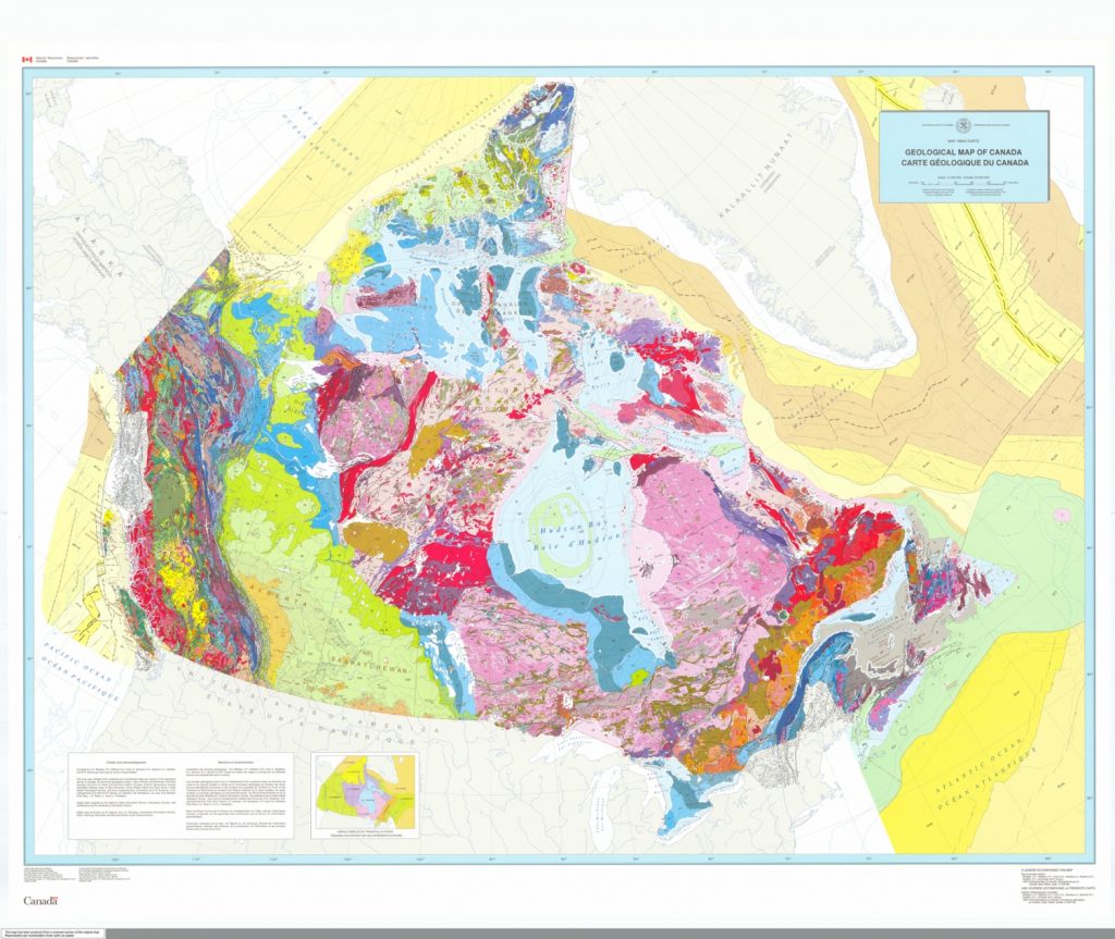
Source: National Resources Canada (1996) Contains information licensed under the Open Government Licence – Canada. Geoscan ID 208175. view source
This broadly varying geology has generated diverse and plentiful mineral and energy resources across our country. Mineral resources include: metals such as gold, silver, and copper; minerals such as diamonds and gypsum; and quarried building materials such as gravel, sand, and limestone. Energy resources include oil, gas, and coal deposits. Examples of mineral and energy resources in Canada include the oil and gas deposits of the prairies of Alberta and Saskatchewan and the base metal (e.g., nickel, lead, copper) mines in BC, the Yukon, Ontario, and Quebec. Some of the geology that hosts these resources is special and unusual, for example the nickel deposits mined at Sudbury, ON were formed from an ancient meteorite impact. Other geology is relatively common, for example sand and gravel are mined at quarries across the country for use in building materials.
We encourage you to take some time to explore Canada’s Mineral and Energy Resources using the Interactive Map on the Natural Resources Canada website. As you explore the geological map (Figure 1.1) and interactive mineral resources map of Canada, it is useful to also look at a map of geological provinces in Canada (Figure 1.2) to help understand how Canadian geology broadly varies across the country.

Geological provinces are areas where the rocks were formed through similar processes over similar ranges of time. Note that their boundaries are different from the political provinces of Canada. There are 6 geological provinces in Canada: the Canadian Shield, the Interior Platform, the Innuitian Orogen, the Cordilleran Orogen, the Appalachian Orogen, and the Continental Margins.
The rocks of the Canadian Shield (pink regions of the map in Figure 1.2) were formed from 4.6 billion to 541 million years ago, a range of time known as the Precambrian. These rocks formed from melted rock that cooled and solidified, and also rocks that were subjected to high pressure and heat after they formed, creating distinctive banded rocks called gneiss (a type of metamorphic rock). At the time the rocks of the Canadian Shield formed, life on earth looked very different – there were no plans or animals, only single-celled organisms! In contrast, the rocks of the Interior Platform (green regions on the map in Figure 1.2) were formed in the Phanerozoic Eon (from 514 million years ago until present). These rocks primarily formed from seawater and from the breakdown of older rocks into tiny particles that were deposited into thick deposits of sediments top of older Precambrian rocks.
In the lab, you will use bedrock geology maps (maps of the types of rocks in an area) and mineral resource maps (maps of where resources are located in an area) to explore the geology and resources across Canada and in your province or territory.
1.3 GEOLOGY & RESOURCE MAPS FOR CANADIAN PROVINCES & TERRITORIES
We have provided links below to bedrock geology and resource maps for each province and territory (if the maps exist).
1.3.1 SASKATCHEWAN GEOLOGY & RESOURCES
1.3.2 BC GEOLOGY & RESOURCES
Map of BC Geology [link dead :-(]
Map of BC Resources [link dead :-(]
1.3.3 ALBERTA GEOLOGY & RESOURCES
1.3.4 MANITOBA GEOLOGY & RESOURCES
Map of Manitoba Geology (Adobe Flash Player required)
Map of Manitoba Resources (Adobe Flash Player required)
1.3.5 ONTARIO GEOLOGY & RESOURCES
Map of Ontario Geology (GoogleEarth required)
Map of Ontario Resources (GoogleEarth required)
1.3.6 QUEBEC GEOLOGY & RESOURCES
Map of Quebec geological domains and a geological overview of Quebec
Interactive Map of Quebec Resources
1.3.7 NEW BRUNSWICK GEOLOGY & RESOURCES
Map of New Brunswick Resources
1.3.8 NOVA SCOTIA GEOLOGY & RESOURCES
Map of Nova Scotia Resources
1.3.9 PRINCE EDWARD ISLAND GEOLOGY & RESOURCES
Map of PEI Geology
Map of PEI Resources
1.3.10 NEWFOUNDLAND & LABRADOR GEOLOGY & RESOURCES
Map of Newfoundland & Labrador Geology
Interactive Map of Newfoundland & Labrador Resources
1.3.11 YUKON TERRITORY GEOLOGY & RESOURCES
Map of Yukon Territory Geology
Map of Yukon Territory Resources
1.3.12 NORTHWEST TERRITORY GEOLOGY & RESOURCES
Map of NWT Geology
Map of NWT Resources
1.3.13 NUNAVUT TERRITORY GEOLOGY & RESOURCES
Map of Nunavut Geology [link :-(]
Map of Nunavut Resources
